
Keywords
QGIS software
Environmental vulnerability
How to Cite
Abstract
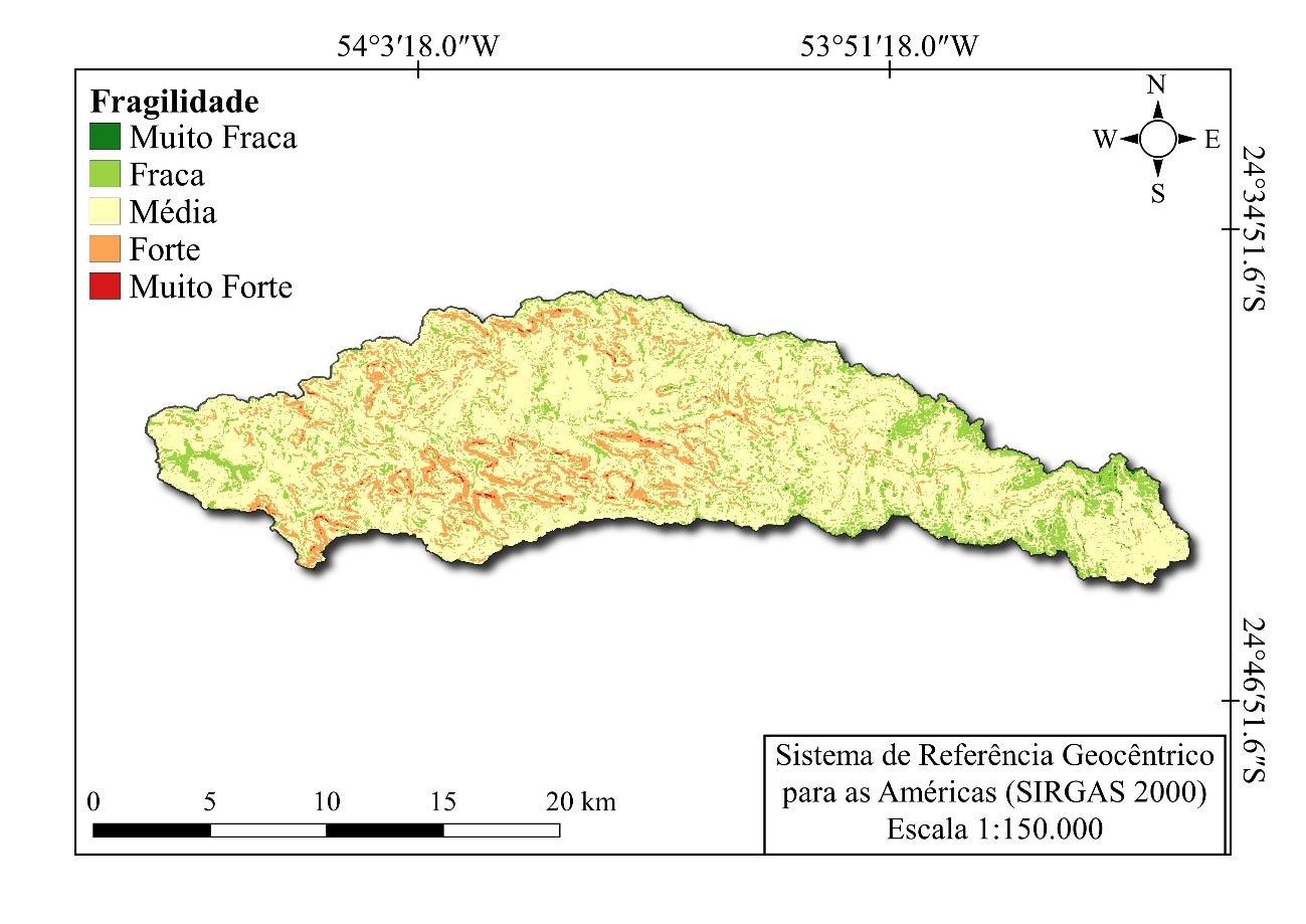
Assessment of environmental fragility in watersheds is an important tool to assist managers in planning and interventions for sustainable production and environmental conservation. The objective of this work was to use Fuzzy logic and the Analytic Hierarchy Process (AHP) method to classify environmental fragility using data obtained from public institutions. The Marreco River watershed in western Paraná, Brazil, was the study model. To classify areas, a geographic information system (GIS) and data from a digital elevation model (DEM), as well as data on soil occupation and type were used. The analysis found that 71.3% of the basin area has average fragility. Compared to two other forms of weighing elements of the slope map, the three presented statistical difference, but all indicated that the basin under study mostly has average environmental fragility. The use of fuzzy logic allowed application of a continuous variation of weights according to the variation of environmental characteristics, which may more effectively represent the reality and, therefore, provide more reliable results. This method may represent a useful tool to appropriately manage sustainable production and environmental conservation in watershed areas.
References
ABRÃO, C. M.R., BACANI, V. M. Diagnóstico da fragilidade ambiental na bacia hidrográfica do Rio Santo Antônio, MS: subsídio ao zoneamento ambiental. Boletim Goiano De Geografia, v.38, n. 3, p. 619–645, 2018. https://doi.org/10.5216/bgg.v38i3.56362
ALBUQUERQUE, E. L.S., de MEDEIROS, C. N. Vulnerabilidade socioambiental em bacias hidrográficas no Setor Leste Metropolitano de Fortaleza, Ceará, Ateliê Geográfico, v. 11, n. 1, p.109–126, 2017. https://doi.org/10.5216/ag.v11i1.39018
ÁVILA, A.; JUSTINO, F.; WILSON, A.; BROMWICH, D.; AMORIM, M. Recent precipitation trends, flash floods and landslides in southern Brazil, Environmental. Research. Letter, v. 11, 114029, 2016. http://dx.doi.org/10.1088/1748-9326/11/11/114029
BANAI, R. Fuzziness in Geographical Information Systems: contributions from the analytic hierarchy process. International Journal of Geographical Information Systems, 7:4, p. 315-329, 1993. https://doi.org/10.1080/02693799308901964
BURROUGH, P. A. Development of intelligent geographical information system. International Journal of Geographical Information Systems, v.1, p. 1-11, 1992. https://doi.org/10.1080/02693799208901891
BURROUGH, P. A.; McDonnell, R. A. Principles of Geographic Information Systems. Oxford: Oxford University, 1998.
BURROUGH, P.A.; MCMILLAN, R.A.; DEURSEN, W. Fuzzy Classification Methods for Determining Land Suitability from Soil Profile Observation and Topography. Journal of Soil Science, v. 43, p. 193-210, 1992. https://doi.org/10.1111/j.1365-2389.1992.tb00129.x
BURROUGH, P. A. Fuzzy mathematical methods for soil survey and land evaluation. Journal of Soil Science, v. 40, p. 477-492, 1989. https://doi.org/10.1111/j.1365-2389.1989.tb01290.x
CEREDA JUNIOR, A, RÖHM, S.A. Analysis of environmental fragility using multicriteria analysis (mce) for integrated landscape assessment. Journal of Urban and Environmental Engineering, v.8, n.1, p.28-37, 2014. https://doi.org/10.4090/juee.2014.v8n1.028037
CHENG, W.; Xi, H.; SINDIKUBWABO, C.; SI, J.; ZHAO, C.; YU, T.; LI, A.; WU, T. Ecosystem health assessment of desert nature reserve with entropy weight and fuzzy mathematics methods: A case study of Badain Jaran Desert, Ecological Indicators, v. 119, 2020. https://doi.org/10.1016/j.ecolind.2020.106843.
CHRISTOFOLETTI, A. Geomorfologia. 2a ed. São Paulo, Edgard Blücher, 1980.
CORNWELL E., SPOSITO V., FAGGIAN R., Land suitability projections for traditional sub-alpine cropping in the Australian Alps and Chilean Dry Andes. A combined biophysical and irrigation potential perspective, Applied Geography, v. 121,2020. https://doi.org/10.1016/j.apgeog.2020.102248
CREPANI, E.; MEDEIROS, J.S.; AZEVEDO, L.C.; DUARTE, V.; HERNANDEZ, P.; FLORENZANO, T.; BARBOSA, C. Sensoriamento Remoto e geoprocessamento aplicados ao zoneamento Ecológico-Econômico e ao ordenamento territorial. INPE, São José dos Campos, São Paulo, 2001. Disponível em: http://sap.ccst.inpe.br/artigos/CrepaneEtAl.pdf . Acesso em: 13 fev. de 2020.
DALLA CORTE, A. P.; KLEIN HENTZ, A. M; DOUBRAWA, B.; SANQUETA, C.R. Environmental fragility of Iguaçu river watershed, Paraná, Brazil. Bosque, vol. 36, n. 2, p. 287-297, 2015. https://doi.org/10.4067/s0717-92002015000200014
de MELLO, C.R.; ALVES, G.J.; BESKOW, S.; NORTON, L.D. Daily rainfall erosivity as an indicator for natural disasters: assessment in mountainous regions of southeastern Brazil, Natural Hazards, v. 103, p. 947–966, 2020. https://doi.org/10.1007/s11069-020-04020-w
dos SANTOS, F. de A., MENDES, L. M.S., da CRUZ, M. L.B. Suscetibilidade biofísica a inundações da Sub-bacia Hidrográfica do rio Piracuruca. Ateliê Geográfico, v. 15, n.1, p.266–285, 2021 https://doi.org/10.5216/ag.v15i1.64590
dos SANTOS, J. Y.G., NASCIMENTO, R.Q. Efeitos das alterações no uso e ocupação do solo nas perdas de solo da bacia do Rio de Janeiro, Oeste da Bahia, Boletim Goiano De Geografia, v. 41, n.1, 2021. https://doi.org/10.5216/bgg.v41.65397
EMBRAPA, Empresa Brasileira de Pesquisa Agropecuária. Sistema Brasileiro de Classificação de Solos, 2ªed. Disponível em: https://www.embrapa.br/solos/sibcs . Acesso em: 17 fev. de 2020.
FRANCISCO, H.R.; CORRÊIA, A.F.; FEIDEN, A. Classification of areas suitable for fish farming using geotechnology and multi-criteria analysis, ISPRS International Journal of Geo-Information, v.8, p.394, 2019. https://doi.org/10.3390/ijgi8090394
FRITZSONS, E.; MANTOVANI, L. E.; AGUIAR, A. V. Relação entre altitude e temperatura: uma contribuição ao zoneamento climático no estado do Paraná. Revista de estudos ambientais, v.10, n. 1, p. 49-64, 2008. http://dx.doi.org/10.7867/1983-1501.2008v10n1p49-64
GEMITZI, A.; FALALAKIS, G.; ESKIOGLOU, P.; PETALAS, C. Evaluating landslide susceptibility using environmental factors, fuzzy membership functions and gis. Global NEST Journal, v. 13, n.1, p. 28-40, 2011. https://doi.org/10.30955/gnj.000734
GUERRERO, J.V.R; PESTANA, L.F.A.; SOARES, J.A.H.; RUIZ, I.H.; MOSCHINI, L.E. Carta de vulnerabilidade natural como instrumento de apoio ao Zoneamento Ecológico-Econômico do município de Pirassununga (São Paulo), Revista Brasileira de Sensoriamento Remoto, v.2, n.2, p.25-42, 2021. Disponível em: https://zenodo.org/record/5548230. Acesso em: 08 out. de 2021
HOSSAIN, M.S.; DAS, N.G. GIS-based multi-criteria evaluation to land suitability modelling for giant prawn (Macrobrachium rosenbergii) farming in Companigonj Upazila of Noakhali. Computers and Electronics in Agriculture, Bangladesh, v.70, p.172–186, 2010. https://doi.org/10.1016/j.compag.2009.10.003
HOYOS, N.; WAYLEN, P.R.; JARAMILLO, A. Seasonal and spatial patterns of erosivity in a tropical watershed of the Colombian Andes. Journal of Hydrology, v.314, p.177–191, 2005. https://doi.org/10.1016/j.jhydrol.2005.03.014
IAPAR, Instituto Agronômico do Paraná. Köppen’s classification. Disponível em: http://www.iapar.br/modules/conteudo/conteudo.php?conteudo=2533 . Acesso em: 30 abr. de 2020.
JUNIOR, C.H.L.S, BEZERRA, D.S., ANDERSON, L.O.,DE ANDRADE, M.R.M., PEREIRA, D.C.A., BEZERRA, V.L.A.R., SILVA, F.B., de ARAGÃO, L.E.O.C. Zoneamento da susceptibilidade a deslizamentos induzidos com base na lógica fuzzy e no processo analítico hierárquico (AHP): o caso da bacia hidrográfica do Rio Anil, São Luís – MA, Revista Brasileira de Cartografia, n.68/9, p. 1819-1837, 2016. Disponível em: https://seer.ufu.br/index.php/revistabrasileiracartografia/article/view/44445. Acesso em: 21 jan. de 2022.
KANDEL, A. Fuzzy mathematical techniques with aplications. Boston: Addison-Wesley Publishing Company, 1986.
KOLLIAS, V. J.; VOLIOTIS, A. Fuzzy reasoning in the development of geographical information systems. International Journal of Geographical Informalion Systems, v.5, p.209-223, 1991. https://doi.org/10.1080/02693799108927844
LEANDRO, D. Modelagem de fragilidade ambiental usando índices baseados em dados especiais e com suporte de sistema especialista, Tese (Doutorado em Ciências Geodésicas), Universidade Federal do Paraná, Curitiba, 2013.
LÓPEZ, A.; AQUINO, A.M.; ASSIS, R. Agricultura de montanha: uma prioridade latente na agenda da pesquisa brasileira. Embrapa Informação Tecnológica, Brasília, 2011.
MADHU, A.; KUMAR, A.; JIA, P. Exploring Fuzzy Local Spatial Information Algorithms for Remote Sensing Image Classification, Remote Sensing, v. 13, 4163, 2021. https://doi.org/10.3390/rs13204163
MALCZEWSKI, J. On the use of weighted linear combination method in GIS: Common and best practice approaches, Transactions in GIS,4, 5–22, 2000. https://doi.org/10.1111/1467-9671.00035
MAPBIOMAS. Coleção da Série Anual de Mapas de Cobertura e Uso de Solo do Brasil. Disponível em: https://plataforma.mapbiomas.org/map#coverage. Acesso em: 17 fev. de 2020.
MEIRELLES, M.S.P. Análise Integrada do Ambiente Através de Geoprocessamento – Uma Proposta Metodológica Para Elaboração de Zoneamentos, Tese (Doutorado em Geografia), Universidade Federal do Rio de Janeiro, 1997.
MELLO, C.R.; VIOLA, M.R.; BESKOW, S.; NORTON, L.D. Multivariate models for annual rainfall erosivity in Brazil, Geoderma, 202–203, 2013. https://doi.org/10.1016/j.geoderma.2013.03.009
MIARA, M.A.; OKA-FIORI, C. Análise por múltiplos critérios para a definição de níveis de fragilidade ambiental – um estudo de caso: bacia hidrográfica do rio Cará-cará, Ponta Grossa/PR, Revista RA´E GA, Curitiba, n. 13, p. 85-98, 2007 http://dx.doi.org/10.5380/raega.v13i0.6642
MIRANDA, J.I. Fundamentos de Sistemas de Informações Geográficas, Brasília,DF, Embrapa Informação Tecnológica, 2005.
NEL, W.; REYNHARDT, D.A.; SUMNER, P.D. Effect of altitude on erosive characteristics of concurrent rainfall events in the northern KwaZulu-Natal Drakensberg. Water AS, v. 36, p.509–512, 2010. https://doi.org/10.4314/wsa.v36i4.58429
PARSIAN, S.; AMANI, M.; MOGHIMI, A.; GHORBANIAN, A.; MAHDAVI, S. Flood Hazard Mapping Using Fuzzy Logic, Analytical Hierarchy Process, and Multi-Source Geospatial Datasets. Remote Sensing, v.13, 4761, 2021. https://doi.org/10.3390/rs13234761
PINESE JÚNIOR, J. F.; RODRIGUES, S. C. O método de análise hierárquica – AHP – como auxílio na determinação da vulnerabilidade ambiental da bacia hidrográfica do Rio Piedade (MG). Revista Do Departamento De Geografia, v.23, p.4-26, 2012. https://doi.org/10.7154/RDG.2012.0023.0001
PLANO DA BACIA HIDROGRÁFICA DO PARANÁ 3, Águas Paraná, 2014. Disponível em: http://www.aguasparana.pr.gov.br/arquivos/File/Parana_3/plano_de_bacia/Produto_01_Caracteristicas_Gerais_da_Bacia_BP3_2014_v07_Final.pdf . Acesso em: 08 abril de 2020.
PMRH, Plano Municipal de Recursos Hídricos de Toledo, 2017. Disponível em: https://www.toledo.pr.gov.br/portal/plano-municipal-de-recursos-hidricos/plano-municipal-de-recursos-hidricos . Acesso em: 12 out. de 2018.
QGIS Project, QGIS User Guide, Release 2.18, 2019. Disponível em: https://docs.qgis.org/2.18/pdf/en/QGIS-2.18-UserGuide-en.pdf Acesso em: 04 fev. 2022R CORE TEAM. R: A language and environment for statistical computing. R foundation for Statistical Computing, Vienna, Austria. Disponível em: https://www.R-project.org/. Acesso em: 15 jul. de 2020.
REGGIANI, P.; HASSANIZADEH, S.M. MEGASCALE thermodynamics in the presence of a conservative field: The watershed case. Advances in Water Resources., v.97, p.73–86, 2016. https://doi.org/10.1016/j.advwatres.2016.09.002
ROSENDO, E.E.Q. Vulnerabilidade à seca nas regiões semiárida brasileira e portuguesa: uma avaliação baseada em lógica fuzzy, Tese (Doutorado em Geografia), Universidade do Porto, Portugal, 2019.
ROSS, J. L. S. Análise empírica da fragilidade dos ambientes naturais e antropizados. Revista do Departamento de Geografia. São Paulo, n. 8, 1994. https://doi.org/10.7154/rdg.1994.0008.0006
SAATY, T.L. A scaling method for priorities in hierarchical structures. J. Math. Psychol., v.15, p.234–281, 1977. https://doi.org/10.1016/0022-2496(77)90033-5
SAATY, R.W. The analytic hierarchy process—What it is and how it is used. Math. Model., v. 9, p.161–176, 1987. https://doi.org/10.1016/0270-0255(87)90473-8
SAATY, T.L. How to make a decision: The analytic hierarchy process. European Journal of Operational Research, v.48, p.9–26, 1990. https://doi.org/10.1016/0377-2217(90)90057-I
SAATY, T. L. Método de Análise Hierárquica, Tradução de Wainer da Silveira e Silva, São Paulo: McGraw-Hill, 1991.
SAATY, T.L.; VARGAS, L.G. Models, Methods, Concepts & Applications of the Analytic Hierarchy Process. International Series in Operations Research & Management Science, Berlin/Heidelberg: Springer, 2012. https://doi.org/10.1007/978-1-4614-3597-6
SCHMIDT, A.M.A. Processo de apoio a tomada de decisão abordagens: AHP e MACBETH, Dissertação (Mestrado em Engenharia de Produção), Universidade Federal de Santa Catarina, Florianópolis, 1995.
SEAB, Secretaria de Estado da Agricultura e do Abastecimento, Departamento de Economia Rural, 2018. Disponível em: http://www.agricultura.pr.gov.br . Acesso em: 14 jul. de 2019.
SILVA, A.B. Sistemas de Informações Geo-referenciadas: conceitos e fundamentos, Campinas, SP, Editora Unicamp, 2003.
SPÖRL, C. Análise de fragilidade ambiental relevo-solo com aplicação de três modelos alternativos nas altas bacias do Rio Jaguari-Mirim, Ribeirão do Quartel e Ribeirão da Prata, Dissertação (Mestrado em Geografia Física), Universidade de São Paulo, 2001.
SPÖRL, C. Metodologia para elaboração de modelos de fragilidade ambiental utilizando redes neurais, Tese (Doutorado em Geografia), Universidade de São Paulo, 2007.
TARBOTON, D.G., Watershed delineation using TAUDEM, A tutorial for using TauDEM to delineate a single watershed, Utah State University, 2011. Disponível em: https://hydrology.usu.edu/taudem/taudem5/TauDEM5DelineatingASingleWatershed.pdf Acesso em: 04 fev. de 2022.
TRICART, J. Ecodinâmica. Rio de Janeiro, IBGE, Diretoria Técnica, SUPREN, 1977.
USGS, United States Geological Survey, EarthExplorer. Disponível em: https://earthexplorer.usgs.gov/ . Acesso em: 01 mar. 2019.
WALTRICK, P. C.; MACHADO, M.A.M.; DIECKOW, J.; OLIVEIRA, D. Estimativa da erosividade de chuvas no estado do Paraná pelo método da pluviometria: atualização com dados de 1986 a 2008. Revista Brasileira de Ciência do Solo, v.39, p.256-267, 2015. https://doi.org/10.1590/01000683rbcs20150147
WESTERVELT, J., SHAPIRO, M., U.S. Army Construction Engineering Research Laboratory. Disponível em: https://grass.osgeo.org/grass76/manuals/r.reclass.html Acesso em: 04 fev. 2022.
WISCHMEIER, W. H. A rainfall erosion index for a universal soil loss equation. Soil Science Society of America Proceedings, v.23, p.246–249, 1959. https://doi.org/10.2136/sssaj1959.03615995002300030027x
WU, X.Z. Development of fragility functions for slope instability analysis, Technical Note, Landslides, v.11, 2014. https://doi.org/10.1007/s10346-014-0536-3
ZADEH, L.A. Fuzzy Sets. Information and Control, v. 8, p.338—353, 1965. https://doi.org/10.1016/S0019-9958(65)90241-X

This work is licensed under a Creative Commons Attribution 4.0 International License.
Copyright (c) 2021 Karen Carrilho Silva Lira, Dr. Humberto Rodrigues Francisco, Dr. Aldi Feiden