
Keywords
Remote Sensing
Synthetic Aperture Radar
Water resources
How to Cite
Abstract
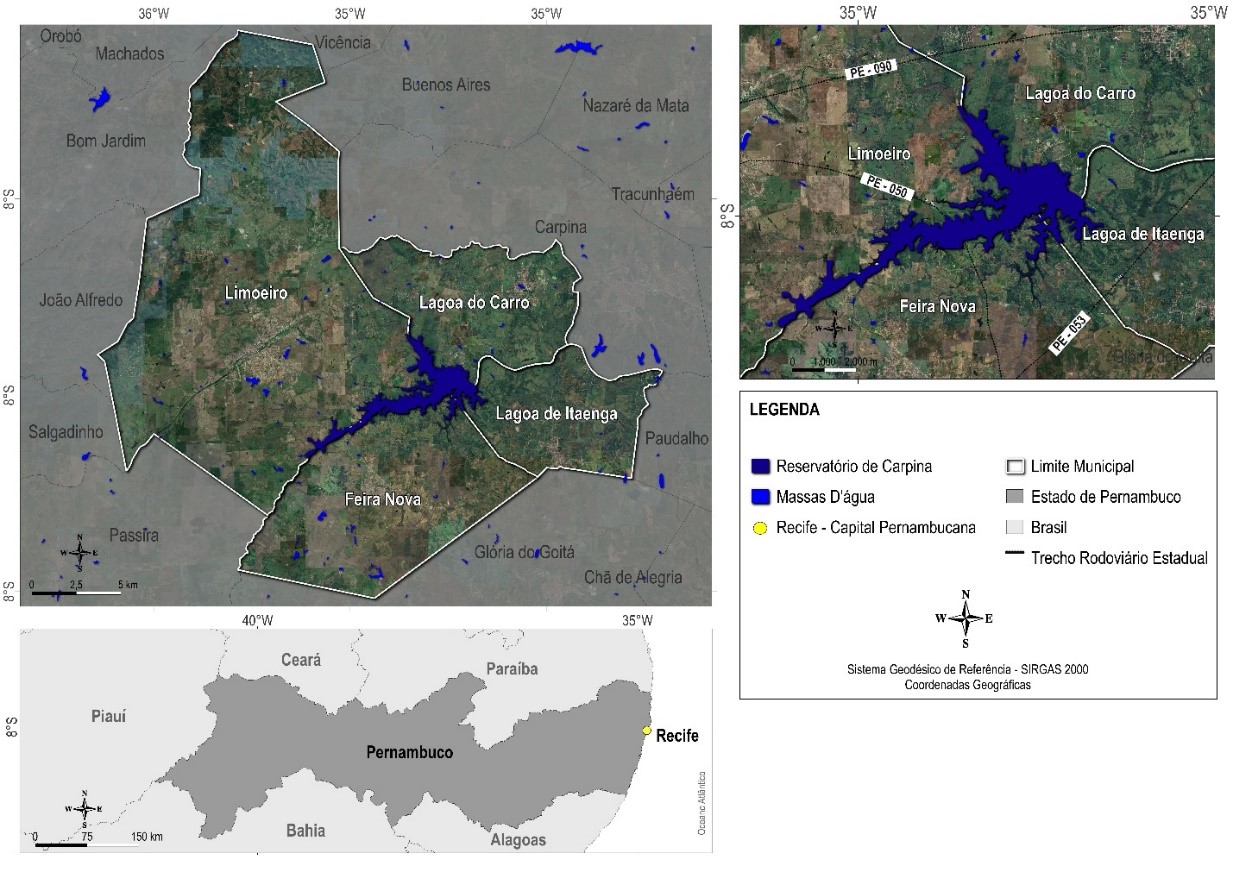
Surface water is the most important resource and environmental factor for maintaining human survival and ecosystem stability, therefore accurate and timely information on surface water is urgently needed. In this study, an image classification approach using Artificial Neural Networks was proposed for mapping the surface water extent of the Carpina-PE Dam using radar image from the Sentinel-1 satellite, as well as its polarizations (VH and VV) and the generated water indices (SDWI and SWI). All datasets presented limitations in detecting small water bodies, such as narrow rivers, and overestimation in pasture areas, generating commission errors ranging from 16.5% to 28.9% and omission errors ranging from 1.47% and 3.5%, with emphasis on VH and VV polarizations. The overall classification accuracy ranged from 96% to 98% and R² values reached close to 1, where the best performance was seen for SDWI and SWI. The comparative experiments indicated that unitary radar polarizations with water spectral indices were useful for improving the accuracy of extracting water bodies in places with clouds, without significant variations, in addition to providing detailed information, with potential for continuous monitoring.
References
BAO, L.; LV, X.; YAO, J. Water Extraction in SAR Images Using Features Analysis and Dual-Threshold Graph Cut Model. Remote Sensing, [S.l.], v. 13, n. 17, p. 3465, 2021. http://dx.doi.org/10.3390/rs13173465.
BOSCHETTI, L.; ROY, D. P.; GIGLIO, L.; HUANG, H.; ZUBKOVA, M.; HUMBER, M. L. Global validation of the collection 6 MODIS burned area product. Remote Sensing of Environment, [S.l.], v. 235, p. 111490, 2019. http://dx.doi.org/10.1016/j.rse.2019.111490
BALAKRISHNAN, M. Geospatial Data Validation Procedure and Techniques. International Archive of Applied Sciences and Technology, [S.l.], v. 10, n. 1, p. 148-153, 2019. https://soeagra.com/iaast/iast_march2019/25f.pdf
COPERNICUS, Data Space Ecosystem. 2023. Disponível em: https://dataspace.copernicus.eu/. Acesso em: 10 nov. 2023.
COSTA JÚNIOR, J. Uso do modelo digital de elevação e do modelo digital de terreno para atualização dos dados de barragens e capacidade de armazenamento de reservatórios em Pernambuco. 2022. Trabalho de Conclusão de Curso (Engenharia Civil) – Universidade Federal de Pernambuco, Caruaru, 2022.
FILIPPONI, Federico. Sentinel-1 GRD Preprocessing Workflow. 3Rd International Electronic Conference On Remote Sensing, [S.l.], p. 100-115, 2019. http://dx.doi.org/10.3390/ecrs-3-06201
GILES, A. B.; DAVIES, J. E.; REN, K.; KELAHER, B. A deep learning algorithm to detect and classify sun glint from high-resolution aerial imagery over shallow marine environments. ISPRS Journal of Photogrammetry and Remote Sensing, v. 181, n. 7, p. 20–26, 2021. Disponível em: https://www.sciencedirect.com/science/article/abs/pii/S0924271621002367?via%3Dihub. Acesso em: 10 de nov. de 2023.
GUO, Z.; WU, L.; HUANG, Y.; GUO, Z.; ZHAO, J.; LI, N. Water-Body Segmentation for SAR Images: past, current, and future. Remote Sensing, [S.L.], v. 14, n. 7, p. 1752, 2022. http://dx.doi.org/10.3390/rs14071752
HASAN, M.; ULLAH, S.; KHAN, M. J.; KHURSHID, K. Comparative analysis of SVM, ann and cnn for classifying vegetation species using hyperspectral thermal infrared data. The International Archives of the Photogrammetry, Remote Sensing and Spatial Information Sciences, v. XLII-2/W13, n. 1, p. 1861–1868, 2019. Disponível em: https://www.int-arch-photogramm-remote-sens-spatial-inf-sci.net/XLII-2-W13/1861/2019/isprs-archives-XLII-2-W13-1861-2019.pdf. Acesso em: 10 nov. 2023.
HENKE-OLIVEIRA, C.; HIROO SAITO, C. A imagem da paisagem e a paisagem da imagem: o sistema de aquisição, processamento, hospedagem e integração de informações sobre recursos ambientais (SAPHIRA). Revista Espaço e Geografia, [S. l.], v. 15, n. 2, p. 385:405, 2022. Disponível em: https://periodicos.unb.br/index.php/espacoegeografia/article/view/39947. Acesso em: 27 mar. 2023.
LAMBERT, M. P. Estudo dos indicadores de risco de inundação no município do recife decorrente do rompimento hipotético da barragem de Carpina. 2022. Trabalho de Conclusão de Curso (Engenharia Civil) - Universidade Federal de Pernambuco, Caruaru, 2021.
LI, M.; HONG, L.; GUO, J.; ZHU, A. Automated Extraction of Lake Water Bodies in Complex Geographical Environments by Fusing Sentinel-1/2 Data. Water, [S.l.], v. 14, n. 1, p. 30, 2021. http://dx.doi.org/10.3390/w14010030
MARTINEZ, J; LETOAN, T. Mapping of flood dynamics and spatial distribution of vegetation in the Amazon floodplain using multitemporal SAR data. Remote Sensing of Environment, [S.l.], v. 108, n. 3, p. 209-223, 2007. http://dx.doi.org/10.1016/j.rse.2006.11.012
NASIR, N; KANSAL, A.; ALSHALTONE, O.; BARNEIH, F.; SHANABLEH, A.; AL-SHABI, M.; SHAMMAA, A. A. Deep learning detection of types of water-bodies using optical variables and ensembling. Intelligent Systems with Applications, [S.l.], v. 18, p. 200222, 2023. http://dx.doi.org/10.1016/j.iswa.2023.200222
PLANET, Analytic Imagery and Archive. 2023. Disponível em: https://www.planet.com/products/planet-imagery/. Acesso em: 10 nov. 2023.
PINHEIRO, M. M. F. Aprendizagem profunda na segmentação semântica de rios em imagens de alta resolução espacial. 2023. 102 f. Tese (Doutorado em Meio Ambiente e Desenvolvimento Regional) - Universidade do Oeste Paulista, Presidente Prudente, 2023.
RAJENDIRAN, N.; KUMAR, L. S. Pixel Level Feature Extraction and Machine Learning Classification for Water Body Extraction. Arabian Journal for Science and Engineering, [S.l.], v. 48, n. 8, p. 9905-9928, 2022. http://dx.doi.org/10.1007/s13369-022-07389-x
SALAH, M. A survey of modern classification techniques in remote sensing for improved image classification. Journal of Geomatics, v. 11, n. 1, 2017. Disponível em: http://isgindia.org/wp-content/uploads/2017/04/016.pdf. Acesso em: 27 mar. 2023.
SON, N.-T.; CHEN, C.-F.; CHEN, C.-R.; TOSCANO, P.; CHENG, Y.-S.; GUO, H.-Y.; SYU, C.-H. A phenological object-based approach for rice crop classification using time-series Sentinel-1 Synthetic Aperture Radar (SAR) data in Taiwan. International Journal of Remote Sensing, [S.l.], v. 42, n. 7, p. 2722-2739, 2021. http://dx.doi.org/10.1080/01431161.2020.1862440
TAMIRU, H.; DINKA, M. O. Application of ANN and HEC-RAS model for flood inundation mapping in lower Baro Akobo River Basin, Ethiopia. Journal of Hydrology: Regional Studies, [S.L.], v. 36, p. 100855, ago. 2021. http://dx.doi.org/10.1016/j.ejrh.2021.100855.
TIAN, Y.; CHEN, X.; LUO, P.; XU, Y. Beijiang water body information extraction based on ENVISAT-ASAR. 2012 Second International Workshop On Earth Observation and Remote Sensing Applications, [S.l.], v. 5, n. 8, p. 100-115, jun. 2012. http://dx.doi.org/10.1109/eorsa.2012.6261181
WANG, X.; GE, L.; LI, X. Pasture Monitoring Using SAR with COSMO-SkyMed, ENVISAT ASAR, and ALOS PALSAR in Otway, Australia. Remote Sensing, [S.l.], v. 5, n. 7, p. 3611-3636, 2013. http://dx.doi.org/10.3390/rs5073611.
XIE, Y.; CHEN, R.; YU, M.; RUI, X.; DU, X. Improvement and application of UNet network for avoiding the effect of urban dense high-rise buildings and other feature shadows on water body extraction. International Journal of Remote Sensing, [S.l.], v. 44, n. 12, p. 3861-3891, 2023. http://dx.doi.org/10.1080/01431161.2023.2229498.
ZHANG, Z.; ZHANG, X.; JIANG, X.; XIN, Q.; AO, Z.; ZUO, Q.; CHEN, L. Automated Surface Water Extraction Combining Sentinel-2 Imagery and OpenStreetMap Using Presence and Background Learning (PBL) Algorithm. Ieee Journal of Selected Topics in Applied Earth Observations And Remote Sensing, [S.l.], v. 12, n. 10, p. 3784-3798, 2019. http://dx.doi.org/10.1109/jstars.2019.2936406

This work is licensed under a Creative Commons Attribution 4.0 International License.
Copyright (c) 2023 Juarez Antonio da Silva Júnior, Ubiratan Joaquim Da Silva Junior