
Palavras-chave
Sensoriamento Remoto
Radar de Abertura Sintética
Recursos Hídricos
Como Citar


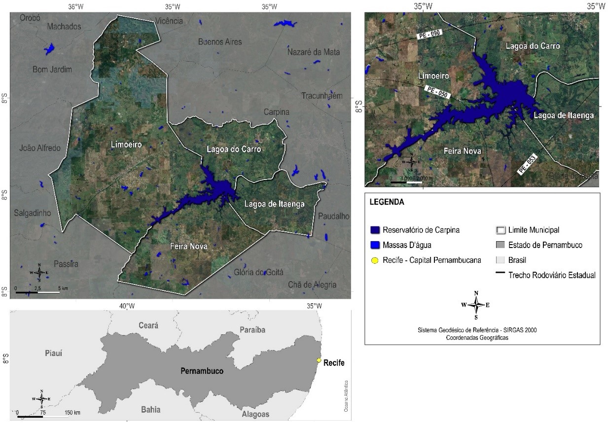
Resumo
A água de superfície é o recurso e fator ambiental mais importante para manter a sobrevivência humana e a estabilidade dos ecossistemas, portanto, informações precisas e oportunas sobre águas superficiais são urgentemente necessárias. Neste estudo foi proposto uma abordagem de classificação de imagens por Redes Neurais Artificiais para o mapeamento da extensão da água de superfície da Barragem de Carpina-PE usando dados (SAR) do satélite Sentinel-1, bem como suas polarizações (VH e VV) e os índices polarimétricos de água gerados (SDWI e SWI). Todos os conjuntos de dados apresentaram limitações na detecção de pequenos corpos hídricos, como rios estreitos, e superestimação em áreas de pastagem, gerando erros de comissão variando de 16,5 % a 28,9% e erros de omissão variando entre 1,47% e 3,5%, com destaque para as polarizações VH e VV. A precisão geral da classificação variou de 96% a 98% e valores de R² chegaram próximo de 1, onde o melhor desempenho foi visto para o SDWI e o SWI. Os experimentos comparativos indicaram que, as polarizações unitárias de radar com índices polarimétricos de água, foram úteis para melhorar a precisão da extração de corpos hídricos em locais com muitas nuvens, sem variações significativas, além de fornecer informações detalhadas, com potencial de monitoramento contínuo.
Referências
BAO, L.; LV, X.; YAO, J. Water Extraction in SAR Images Using Features Analysis and Dual-Threshold Graph Cut Model. Remote Sensing, [S.l.], v. 13, n. 17, p. 3465, 2021. http://dx.doi.org/10.3390/rs13173465.
BOSCHETTI, L.; ROY, D. P.; GIGLIO, L.; HUANG, H.; ZUBKOVA, M.; HUMBER, M. L. Global validation of the collection 6 MODIS burned area product. Remote Sensing of Environment, [S.l.], v. 235, p. 111490, 2019. http://dx.doi.org/10.1016/j.rse.2019.111490
BALAKRISHNAN, M. Geospatial Data Validation Procedure and Techniques. International Archive of Applied Sciences and Technology, [S.l.], v. 10, n. 1, p. 148-153, 2019. https://soeagra.com/iaast/iast_march2019/25f.pdf
COPERNICUS, Data Space Ecosystem. 2023. Disponível em: https://dataspace.copernicus.eu/. Acesso em: 10 nov. 2023.
COSTA JÚNIOR, J. Uso do modelo digital de elevação e do modelo digital de terreno para atualização dos dados de barragens e capacidade de armazenamento de reservatórios em Pernambuco. 2022. Trabalho de Conclusão de Curso (Engenharia Civil) – Universidade Federal de Pernambuco, Caruaru, 2022.
FILIPPONI, Federico. Sentinel-1 GRD Preprocessing Workflow. 3Rd International Electronic Conference On Remote Sensing, [S.l.], p. 100-115, 2019. http://dx.doi.org/10.3390/ecrs-3-06201
GILES, A. B.; DAVIES, J. E.; REN, K.; KELAHER, B. A deep learning algorithm to detect and classify sun glint from high-resolution aerial imagery over shallow marine environments. ISPRS Journal of Photogrammetry and Remote Sensing, v. 181, n. 7, p. 20–26, 2021. Disponível em: https://www.sciencedirect.com/science/article/abs/pii/S0924271621002367?via%3Dihub. Acesso em: 10 de nov. de 2023.
GUO, Z.; WU, L.; HUANG, Y.; GUO, Z.; ZHAO, J.; LI, N. Water-Body Segmentation for SAR Images: past, current, and future. Remote Sensing, [S.L.], v. 14, n. 7, p. 1752, 2022. http://dx.doi.org/10.3390/rs14071752
HASAN, M.; ULLAH, S.; KHAN, M. J.; KHURSHID, K. Comparative analysis of SVM, ann and cnn for classifying vegetation species using hyperspectral thermal infrared data. The International Archives of the Photogrammetry, Remote Sensing and Spatial Information Sciences, v. XLII-2/W13, n. 1, p. 1861–1868, 2019. Disponível em: https://www.int-arch-photogramm-remote-sens-spatial-inf-sci.net/XLII-2-W13/1861/2019/isprs-archives-XLII-2-W13-1861-2019.pdf. Acesso em: 10 nov. 2023.
HENKE-OLIVEIRA, C.; HIROO SAITO, C. A imagem da paisagem e a paisagem da imagem: o sistema de aquisição, processamento, hospedagem e integração de informações sobre recursos ambientais (SAPHIRA). Revista Espaço e Geografia, [S. l.], v. 15, n. 2, p. 385:405, 2022. Disponível em: https://periodicos.unb.br/index.php/espacoegeografia/article/view/39947. Acesso em: 27 mar. 2023.
LAMBERT, M. P. Estudo dos indicadores de risco de inundação no município do recife decorrente do rompimento hipotético da barragem de Carpina. 2022. Trabalho de Conclusão de Curso (Engenharia Civil) - Universidade Federal de Pernambuco, Caruaru, 2021.
LI, M.; HONG, L.; GUO, J.; ZHU, A. Automated Extraction of Lake Water Bodies in Complex Geographical Environments by Fusing Sentinel-1/2 Data. Water, [S.l.], v. 14, n. 1, p. 30, 2021. http://dx.doi.org/10.3390/w14010030
MARTINEZ, J; LETOAN, T. Mapping of flood dynamics and spatial distribution of vegetation in the Amazon floodplain using multitemporal SAR data. Remote Sensing of Environment, [S.l.], v. 108, n. 3, p. 209-223, 2007. http://dx.doi.org/10.1016/j.rse.2006.11.012
NASIR, N; KANSAL, A.; ALSHALTONE, O.; BARNEIH, F.; SHANABLEH, A.; AL-SHABI, M.; SHAMMAA, A. A. Deep learning detection of types of water-bodies using optical variables and ensembling. Intelligent Systems with Applications, [S.l.], v. 18, p. 200222, 2023. http://dx.doi.org/10.1016/j.iswa.2023.200222
PLANET, Analytic Imagery and Archive. 2023. Disponível em: https://www.planet.com/products/planet-imagery/. Acesso em: 10 nov. 2023.
PINHEIRO, M. M. F. Aprendizagem profunda na segmentação semântica de rios em imagens de alta resolução espacial. 2023. 102 f. Tese (Doutorado em Meio Ambiente e Desenvolvimento Regional) - Universidade do Oeste Paulista, Presidente Prudente, 2023.
RAJENDIRAN, N.; KUMAR, L. S. Pixel Level Feature Extraction and Machine Learning Classification for Water Body Extraction. Arabian Journal for Science and Engineering, [S.l.], v. 48, n. 8, p. 9905-9928, 2022. http://dx.doi.org/10.1007/s13369-022-07389-x
SALAH, M. A survey of modern classification techniques in remote sensing for improved image classification. Journal of Geomatics, v. 11, n. 1, 2017. Disponível em: http://isgindia.org/wp-content/uploads/2017/04/016.pdf. Acesso em: 27 mar. 2023.
SON, N.-T.; CHEN, C.-F.; CHEN, C.-R.; TOSCANO, P.; CHENG, Y.-S.; GUO, H.-Y.; SYU, C.-H. A phenological object-based approach for rice crop classification using time-series Sentinel-1 Synthetic Aperture Radar (SAR) data in Taiwan. International Journal of Remote Sensing, [S.l.], v. 42, n. 7, p. 2722-2739, 2021. http://dx.doi.org/10.1080/01431161.2020.1862440
TAMIRU, H.; DINKA, M. O. Application of ANN and HEC-RAS model for flood inundation mapping in lower Baro Akobo River Basin, Ethiopia. Journal of Hydrology: Regional Studies, [S.L.], v. 36, p. 100855, ago. 2021. http://dx.doi.org/10.1016/j.ejrh.2021.100855.
TIAN, Y.; CHEN, X.; LUO, P.; XU, Y. Beijiang water body information extraction based on ENVISAT-ASAR. 2012 Second International Workshop On Earth Observation and Remote Sensing Applications, [S.l.], v. 5, n. 8, p. 100-115, jun. 2012. http://dx.doi.org/10.1109/eorsa.2012.6261181
WANG, X.; GE, L.; LI, X. Pasture Monitoring Using SAR with COSMO-SkyMed, ENVISAT ASAR, and ALOS PALSAR in Otway, Australia. Remote Sensing, [S.l.], v. 5, n. 7, p. 3611-3636, 2013. http://dx.doi.org/10.3390/rs5073611.
XIE, Y.; CHEN, R.; YU, M.; RUI, X.; DU, X. Improvement and application of UNet network for avoiding the effect of urban dense high-rise buildings and other feature shadows on water body extraction. International Journal of Remote Sensing, [S.l.], v. 44, n. 12, p. 3861-3891, 2023. http://dx.doi.org/10.1080/01431161.2023.2229498.
ZHANG, Z.; ZHANG, X.; JIANG, X.; XIN, Q.; AO, Z.; ZUO, Q.; CHEN, L. Automated Surface Water Extraction Combining Sentinel-2 Imagery and OpenStreetMap Using Presence and Background Learning (PBL) Algorithm. Ieee Journal of Selected Topics in Applied Earth Observations And Remote Sensing, [S.l.], v. 12, n. 10, p. 3784-3798, 2019. http://dx.doi.org/10.1109/jstars.2019.2936406

Este trabalho está licenciado sob uma licença Creative Commons Attribution 4.0 International License.
Copyright (c) 2023 Juarez Antonio da Silva Júnior, Ubiratan Joaquim Da Silva Junior