
Palavras-chave
Morfoestrutura
Morfotectônica
Como Citar
Resumo
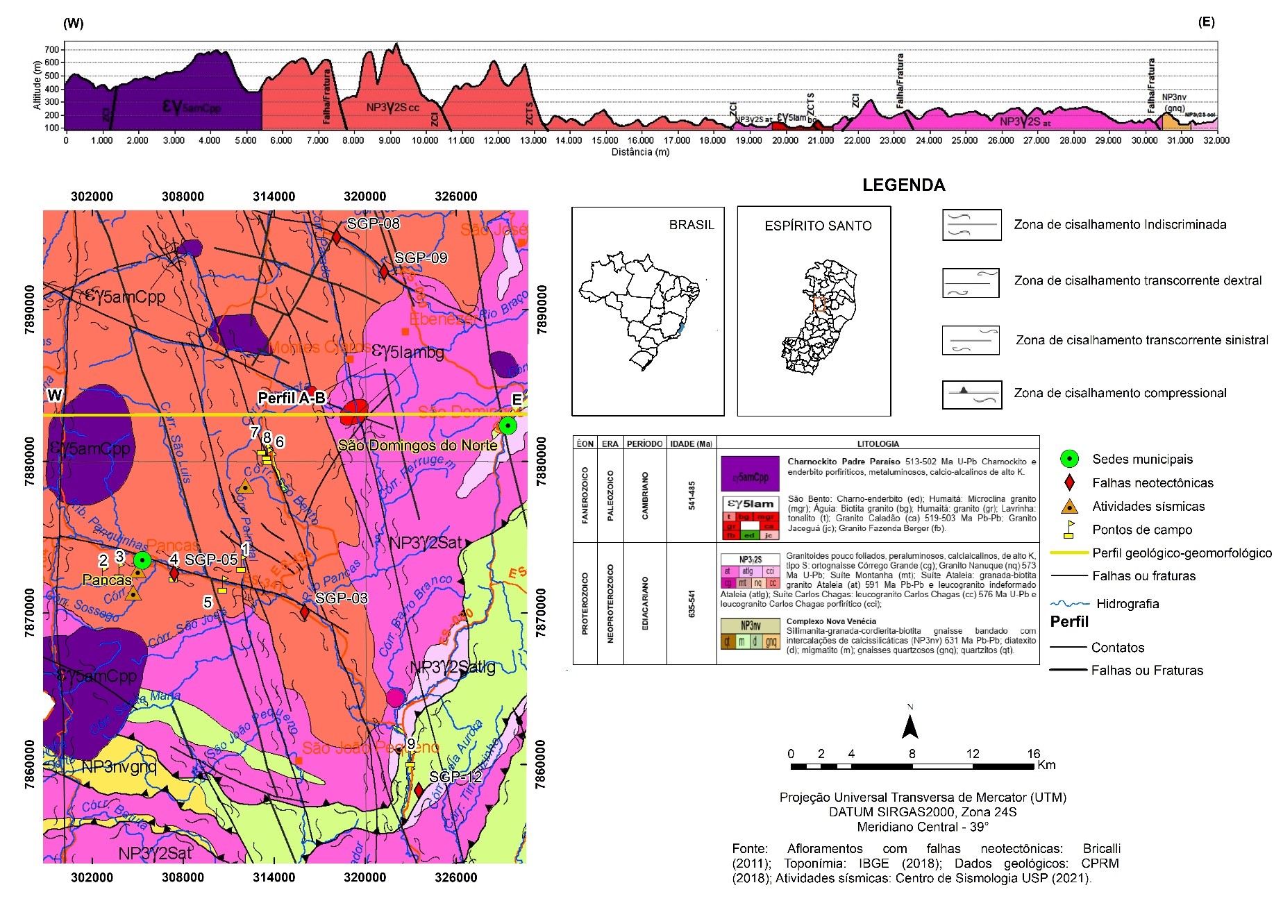
Esta pesquisa tem como objetivo principal investigar o controle litoestrutural, tectônico e neotectônico no relevo da região de Pancas (Espírito Santo, Sudeste do Brasil). A metodologia foi organizada em análises de gabinete e de campo. Em gabinete foram gerados mapas de lineamentos e de trends estruturais, a partir da técnica de extração manual, utilizando ferramentas de edição do software ArcGIS 10.3.1™ (ESRI, 2012), sobre um Modelo Digital de Elevação (MDE) com diferentes iluminações artificiais (escala 1:110.000) e geradas rosetas de orientação. Os mapas geológicos e geomorfológicos foram organizados/elaborados com o ArcGIS, a partir do Sistema de Informações Geográficas (SIG) e as bases cartográficas foram configuradas no sistema de projeção UTM e DATUM SIRGAS 2000, zona 24S, posteriormente analisados e comparados com os dados das orientações dos lineamentos decalcados, com a orientação das falhas de afloramentos estudados e com a literatura existente. Os resultados apresentaram orientações NW-SE/NNW-SSE e NE-SW/NNE-SSW, com a predominância das orientações NNW-SSE e NW-SE identificadas na análise dos lineamentos e dos trends estruturais, semelhantes com as orientações das falhas geológicas e das falhas neotectônicas presentes na área estudada, refletindo a estruturação regional da área, apresentando as mesmas orientações da Faixa Colatina. As orientações secundárias do Orógeno Araçuaí (NE-SW), a identificação de feições morfotectônicas, a presença de diferenças topográficas abruptas (perfis topográficos), a identificação de regiões tectônicas (mapa de superfície de bases) e de blocos tectônicos (perfil em varredura) demonstram o controle tectônico no relevo da região de Pancas-ES, atingindo o objetivo desta pesquisa.
Referências
ALLMENDINGER, R. W.; CARDOZO, N. C.; FISHER, D. M. Structural Geology Algorithms: Vectors & Tensors: Cambridge, England, Cambridge University Press, 2013. 289 p.
BARROS, L. D. de. Pancas-ES. 2022. 1 fotografia.
BRICALLI, L. L. Padrões de lineamento e faturamento neotectônico no Estado do Espírito Santo (Sudeste do Brasil). Tese (Doutorado em Geologia) – Instituto de Geociências, Universidade Federal do Rio de Janeiro, Rio de Janeiro, 2011.
BRICALLI, L. L.; MELLO, C. L. Padrões de lineamentos relacionados à litoestrutura e ao faturamento neotectônico (Estado do Espírito Santo, SE do Brasil). Revista Brasileira de Geomorfologia. v. 14, n. 3, 2013. https://doi.org/10.20502/rbg.v14i3.405
CAUS, T. W. Danos em residência. Pancas-ES. 2022. 1 fotografia.
Centro de Sismologia USP. Disponível em: https://www.moho.iag.usp.br/. Acesso em: 1 mar. 2021.
CPRM Serviço Geológico do Brasil. Mapa geológico do Estado do Espírito Santo. Escala 1:400.000. 2018.
ESRI Inc. ArcMap (versão 10.3.1). Redlands, Estados Unidos, 2012.
FERRARI, A. L. Evolução Tectônica do Graben da Guanabara. 2001. 412p. Tese (Doutorado em Geologia) - Instituto de Geociências, Universidade São Paulo, São Paulo, 2001.
Folha SE.24, Rio Doce, Escala 1: 1.000.000. Geologia, geomorfologia, pedologia, vegetação, uso potencial da terra. Fundação Instituto Brasileiro de Geografia e Estatística. Rio de Janeiro. IBGE, 1987.
GATTO, L. C. S.; RAMOS, V. L. S.; NUNES, B. T. A.; MAMEDE, L.; GÓES, M. H.; MAURO, C. A.; ALVARENGA, S. M.; FRANCO, E. M. S.; QUIRICO, A. F.; NEVES, L. B. Geomorfologia. Projeto Radam Brasil. Folhas 23/24 Rio de Janeiro/Vitória. V 32. Rio de Janeiro, 1983.
GEOBASES – Sistema Integrado de Bases Geoespaciais do Estado do Espírito Santo (2021). Disponível em: https://geobases.es.gov.br. Acesso em: 1 mar. 2021.
GOOGLE. Google Earth (2022). Disponível em: https://earth.google.com/web. Acesso em: 1 dez. 2022.
HEILBRON et al. Província Mantiqueira - In: MANTESSO-NETO et al. Geologia do Continente Sul-Americano. São Paulo: Beca, p. 204-234, 2004.
IBGE - INSTITUTO BRASILEIRO DE GEOGRAFIA E ESTATÍSTICA. Carta São Gabriel da Palha (Folha SE.24-Y-C-III). Rio de Janeiro: 1979. Escala 1:100.000.
IBGE – INSTITUTO BRASILEIRO DE GEOGRAFIA E ESTATÍSTICA. Portal de downloads. 2018. Disponível em: https://www.ibge.gov.br/geociencias/downloads-geociencias.html. Acesso em: 1 de mar. 2021.
LIU, C. C. Análise Estrutural de lineamentos em imagens de sensoriamento remoto: aplicação ao Estado do Rio de Janeiro. Programa de Pós-graduação em Geociências. Universidade de São Paulo, Tese de Doutorado, 157p, 1984.
MACHADO FILHO, L. M.; RIBEIRO, M. W.; GONZALEZ, S. R.; SCHENINI, C. A.; NETO, A. S.; PALMEIRA, R.C.B; PIRES, J.L; TEIXEIRA, W; CASTRO, H. E. F. Geologia. Projeto Radam Brasil. Folhas 23/24 Rio de Janeiro/Vitória. v. 32. Rio de Janeiro, 1983.
MEIS, M. R. M. Desenvolvimento de altitude como parâmetro para a
compartimentação do relevo: bacia do médio-baixo Paraíba do Sul. IN: Anais do XXXII Congresso Brasileiro de Geologia. Salvador, 1982.
MELLO, C. L.; METELO, C. M. S.; SUGUIO, K.; KOHLER, H. C. Quaternary sedimentation, neotectonics and the evolution of the doce river middle valley lake system (Southern Brazil). Revista do Instituto Geológico, v. 20, n.1/2, p. 29-36, 1999. https://doi.org/10.5935/0100-929X.19990003
MENDES, I. A.; DANTAS, M.; BEZERRA, L. M. M. Folha SE.24, Rio Doce, Escala 1: 1.000.000. Geologia, geomorfologia, pedologia, vegetação, uso potencial da terra. Fundação Instituto Brasileiro de Geografia e Estatística. Rio de Janeiro. IBGE, 1987.
MIRANDA, D. J. Análise de estruturas rúpteis associadas a deformações neotectônicas na região centro-norte do estado do Espírito Santo. 58 p. Trabalho de Conclusão de Curso (Bacharelado em Geologia) – Instituto de Geociências, Universidade Federal do Rio de Janeiro, Rio de Janeiro, 2007.
MIRANDA, D. J. Tensões e fraturamento neotectônico na área emersa da bacia do Espírito Santo. 2009. 125p. Dissertação (Mestrado em Geologia) - Instituto de Geociências, Universidade Federal do Rio de Janeiro, Rio de Janeiro, 2009.
NOVAIS, L. C. C. et al. Novas ocorrências de diques de diabásio na faixa Colatina - ES: estruturas rúpteis associadas e implicações tectônicas para as bacias de Campos e do Espírito Santo. - In: B. GEOCI. PETROBRÁS, 12, 2004, Rio de Janeiro.
NOVAIS, L.C.C. Lineamentos transversais nas porções centro e norte da bacia do Espírito Santo e na faixa Proterozoica adjacente: influência na sedimentação e na compartimentação estrutural. Dissertação (Mestrado em análise de bacias e faixas móveis) – Faculdade de Geologia, Universidade do Estado do Rio de Janeiro, Rio de Janeiro, 2005.
OLIVEIRA, L. C.; GAMA DE OLIVEIRA, R. M. A.; PEREIRA, E. Possível Controle Neotectônico sobre as Falésias do Litoral Sul da Bahia. Anuário do Instituto de Geociências – UFRJ. ISSN 0101-9759 e-ISSN 1982-3908 - v. 41, n. 3, p. 702-716, 2018. https://doi.org/10.11137/2018_3_702_716
ORIANA (version 3.2.1). 2022. Disponível em: <http://www.kovcomp.co.uk/oriana/index.html>. Acesso em: 10 jun. 2022.
PEDROSA-SOARES, A.C. & WIEDEMANN-LEONARDOS, C. M. Evolution of the Araçuaí Belt and its connection to the Ribeira Belt, Eastern Brazil. IN: CORDANI, U. G.; MILANI, E. J.; THOMAZ FILHO, A.; CAMPOS, D. A. (ed.) Tectonic Evolution of South America. 2000. p. 265-285.
QUEIROZ, G. L.; SALAMUNI, E.; NASCIMENTO, E. R. AzimuthFinder: ferramenta para a extração de dados e apoio na análise estrutural. Revista do Instituto de Geociências – USP. Série científica. São Paulo, v. 14, n. 1, p. 6-80, 2014. https://doi.org/10.5327/Z1519-874X201400010005
RIBEIRO, C. S. Influência da tectônica pós-deposicional na distribuição da Formação Barreiras entre o rio Paraíba do Sul (RJ) e o rio Doce (ES). 2010. 164 p. Dissertação (Mestrado em Geologia) - Instituto de Geociências, Universidade Federal do Rio de Janeiro, Rio de Janeiro, 2010.
RICCOMINI, C.; SANT’ANNA, L. G.; FERRARI, A. L. Evolução geológica do Rift Continental do Sudeste do Brasil. In: MANTESSO-NETO, V.; BARTORELLI, A.; CARNEIRO, C. D. R.; BRITO NEVES, B. B. (orgs.). Geologia do Continente Sul Americano: evolução da obra de Fernando Flávio Marques de Almeida. São Paulo, Beca, p.383-405, 2004.
SALVADOR, E. D.; PIMENTEL, J. Avaliação da neotectônica no município de Angra dos Reis, setor sul-fluminense da Serra do Mar, com base em mapas morfométricos gerados em Sistemas de Informações Geográficas (SIG). In: SIMPÓSIO BRASILEIRO DE SENSORIAMENTO REMOTO. Natal, 2009. Disponível em: http://marte.sid.inpe.br/col/dpi.inpe.br/sbsr%4080/2008/11.14.09.37/doc/3347-3354.pdf. Acesso em: 15 nov. 2021.
SILVA, J. M. R.; LIMA, M. I. C.; VERONESE, V. F.; JUNIOR, R. N. R.; ROCHA, R. M.; JUNIOR, O. S. Folha SE.24, Rio Doce, Escala 1: 1.000.000. Geologia, geomorfologia, pedologia, vegetação, uso potencial da terra. Fundação Instituto Brasileiro de Geografia e Estatística. Rio de Janeiro. IBGE, 1987.
SILVA, T. P. Neotectônica na região da Zona de Cisalhamento do rio Paraíba do Sul e áreas adjacentes. 125p. Dissertação (Mestrado em Geologia) – Instituto de Geociências, Universidade Federal do Rio de Janeiro, Rio de Janeiro, 2006. https://doi.org/10.11137/2006_2_287-288
STRAHLER, A. N. Hypsometric (area-altitude) – analysis of erosion al topography. Geological Society of America Bulletin, v.63, n.10, p.1117-1142, 1952. https://doi.org/10.1130/0016-7606(1952)63[1117:HAAOET]2.0.CO;2
SUMMERFIELD, M.A. Neotectonics and landform genesis. Prog. in Phys. Geog., v. 11, n. 3, p. 385-397, 1987. https://doi.org/10.1177/030913338701100305
TOPODATA – Banco de Dados Geomorfométricos do Brasil. Disponível em: http://www.dsr.inpe.br/topodata/. Acesso em: 10 set. 2020.
TUPINAMBÁ, M.; HEILBRON, M.; DUARTE, B. P.; NOGUEIRA, J. R.; VALLADARES, C.; ALMEIDA, J. C. H.; SILVA, L. G. E.; MEDEIROS, S. R.; GUIA, C.; MIRANDA, A. W. A.; RAGATKI, C. D.; MENDES, J.; LUDKA, I. Geologia da faixa ribeira setentrional: estado da arte e conexões com a Faixa Araçuaí. GEONOMOS, v. 15, p. 67-79, 2013. https://doi.org/10.18285/geonomos.v15i1.108
VALERIANO, M. M. Mapeamento do comprimento de rampa em microbacias com sistemas de informação geográfica. Acta Scientiarum (UEM), Maringá, PR, v. 24, n. 5, p. 1541-1551, 2002. https://doi.org/10.4025/actasciagron.v24i0.2423
WIEDEMANN-LEONARDOS C. M.; LUDKA I. P.; MEDEIROS S.R.; MENDES J.C.; COSTA-DE-MOURA J. Arquitetura de plutons zonados da Faixa Araçuaí-Ribeira. Geonomos, v. 15, n. 1, p. 25-28, 2000. https://doi.org/10.18285/geonomos.v8i1.145

Este trabalho está licenciado sob uma licença Creative Commons Attribution 4.0 International License.
Copyright (c) 2022 Marcos Cesar Luna da Silva, Luiza Leonardi Bricalli