
Palavras-chave
Sistema de Informação Geográfica
Balanço hídrico
Escoamento superficial
Recarga de aquíferos
Como Citar


Resumo
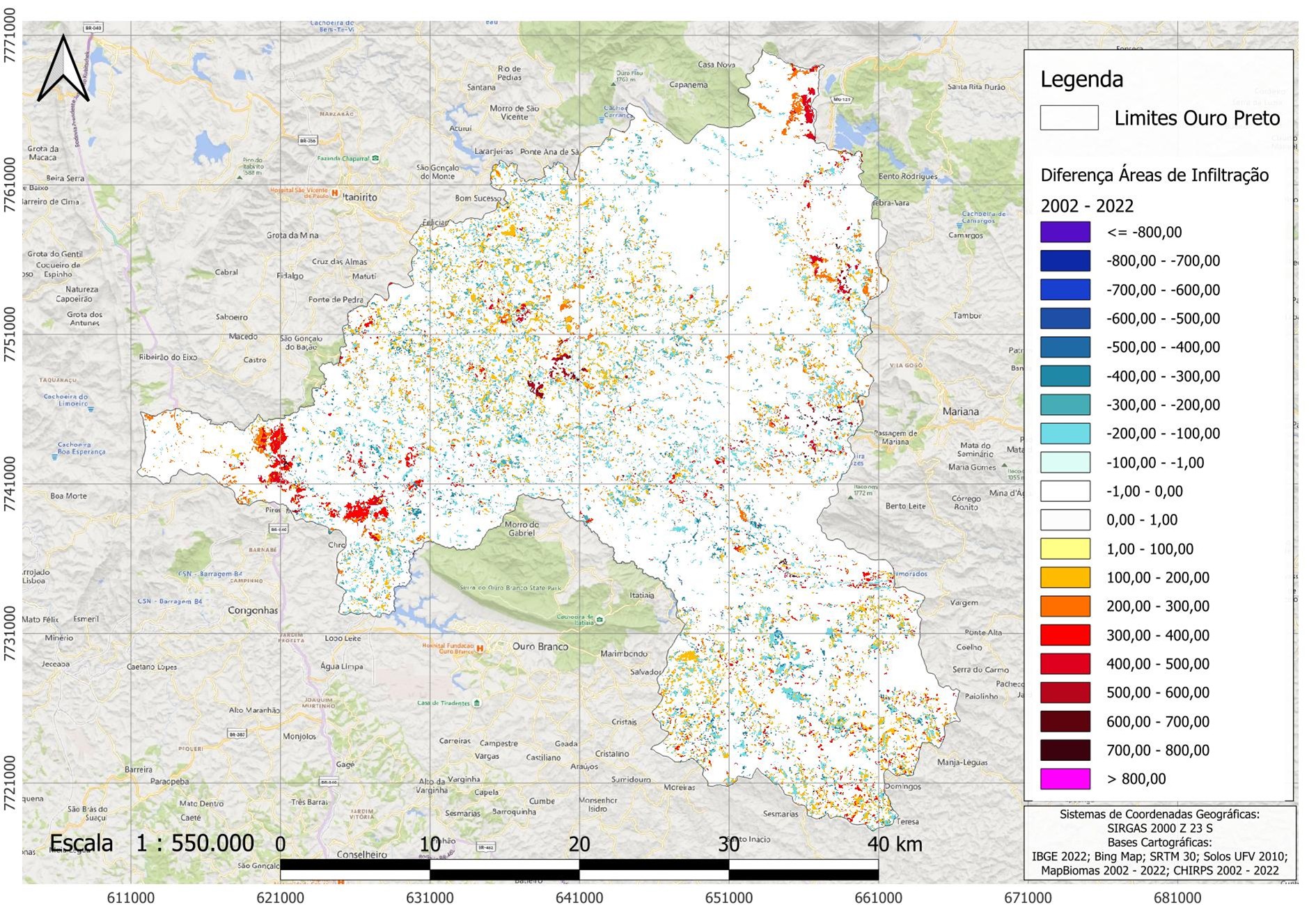
A água é um elemento essencial à vida e a sua gestão nos territórios é necessária para garantir que seja universalmente acessível e para manter a sua qualidade e quantidade. Intervenções mal planejadas na paisagem intensificam problemas relacionados à erosão, assoreamento, enchentes, deslizamentos e escassez de água potável. Entre os processos essenciais para a gestão dos recursos hídricos destaca-se o escoamento superficial e a infiltração, que são influenciados diretamente pelas modificações no uso e cobertura da terra. Dessa forma, o objetivo do presente estudo foi analisar os efeitos das mudanças no uso e cobertura da terra ocorridas entre 2002 e 2022 sobre as taxas de escoamento superficial e de infiltração no município de Ouro Preto, MG. Inicialmente, foi estimado o coeficiente de escoamento com base nos mapas de declividade, classes de solo e uso e cobertura da terra de 2002 e 2022. Posteriormente, foi elaborado o mapa de escoamento multiplicando o coeficiente pela precipitação média anual. Finalmente, foi elaborado o mapa de infiltração utilizando o cálculo do saldo de água, subtraindo o escoamento e a evapotranspiração. O geoprocessamento foi feito em plataforma SIG com dados de sensoriamento remoto utilizando o software QGIS. Os resultados indicam aumento da taxa de escoamento superficial e diminuição da infiltração, principalmente na porção oeste, norte e central do município. Situação preocupante considerando que as menores taxas de infiltração estão sobre aquíferos de grande potencial, prejudicando a sua recarga. O aumento das taxas de escoamento intensifica os problemas de erosão, situação especialmente alarmante na região central, onde o solo é propício para a ocorrência de voçorocas.
Referências
ALMEIDA, F. F. M. de. O Cráton de São Francisco. Revista Brasileira de Geociências, v. 7, p. 349-364, 1977. https://doi.org/10.25249/0375-7536.1977349364
ASCE - AMERICAN SOCIETY OF CIVIL ENGINEERS; WPCF - WATER POLLUTION CONTROL FEDERATION. Design and construction of sanitary and storm sewers. New York: American Society of Civil Engineers, p. 1 – 332, 1986 (1969 Reprint). Available: https://ahmadsana.tripod.com/Courses/project1/sewer-specs.pdf. Accessed on: feb. 4, 2026.
ANDRADE, L. N.; LEITE, M. G. P.; BACELLAR, L. A. P. Composição mineralógica e geoquímica dos solos do Parque Estadual do Itacolomi - Ouro Preto/MG. Quaternary and Environmental Geosciences, v. 3, 2012. https://doi.org/10.5380/abequa.v3i1-2.16838
BARAZZUOLI, P.; IZZO, S.; MENICORI, P.; MICHELUCCINI, M.; SALLEOLINI, M. A new practical aid to regional hydrogeologic planning: the runoff coefficient map. Environmental Management, v. 13, n. 5, p. 613–622, 1989. https://doi.org/10.1007/bf01874967
BARBEDO, R.; FLEISCHMANN A. S.; SIQUEIRA, V.; BRÊDA, J. P.; MATTE, G.; LAIPELT, L.; AMORIM, A.; ARAÚJO, A. A.; FUCKNER, M.; MELLER, A.; FAN, F. M.; COLLISCHONN, W.; RUHOFF, A.; PAIVA, C. D. de. Water storage variability across Brazil. Revista Brasileira de Recursos Hídricos, v. 27, e32, 2020. https://doi.org/10.1590/2318-0331.272220220077
BARFIELD, B. J.; WARNER, R. C.; HAAN, C. T. Applied Hydrology and Sedimentology for Disturbed Areas. Oklahoma Technical Press, Stillwater, Oklahoma, p. 12-49, 1983. Available: https://semspub.epa.gov/work/05/224351.pdf. Accessed on: feb. 4, 2026.
BONNA, J. L. Mapeamento pedológico e de suscetibilidade erosiva no Alto Córrego Prata (Ouro Preto-MG). Dissertação (Mestrado em Geografia) – Universidade Federal de Minas Gerais, Belo Horizonte, 2011. Available: http://hdl.handle.net/1843/MPBB-8RBKKX Accessed on: feb. 4, 2026.
COSTA, A. M. da; SALIS, H. H. C. de; VIANA, J. H. M.; LEAL PACHECO, F. A. Groundwater recharge potential for sustainable water use in urban areas of the Jequitiba River Basin, Brazil. Sustainability, v. 11, n. 10, p. 2955, 2019. https://doi.org/10.3390/su11102955
COSTA, S. Â. D.; KER, J. C.; SIMÕES, D. F. F.; FONTES, M. P. F.; FABRIS, J. D.; ANDRADE, F. V. Pedogênese e classificação de latossolos desenvolvidos de itabiritos no Quadrilátero Ferrífero, MG. Revista Brasileira de Ciência do Solo, v. 38, n. 2, p. 359–371, 2014. https://doi.org/10.1590/S0100-06832014000200001
CPRM - SERVIÇO GEOLÓGICO DO BRASIL; CODEMIG. Mapas geológico e de recursos minerais do estado de Minas Gerais. Belo Horizonte: CPRM, 2014. Escala 1:1.000.000. Available: https://rigeo.sgb.gov.br/handle/doc/20786. Accessed on: feb. 4, 2026.
D’ALBERTO, L.; LUCIANETTI, G. Misinterpretation of the Kenessey method for the determination of the runoff coefficient: a review. Hydrological Sciences Journal, 2019. https://doi.org/10.1080/02626667.2019.1578965
DELGADO, M. I.; CAROL, E. S.; CASCO, M. A. Land-use changes in the periurban interface: Hydrologic consequences on a flatland-watershed scale. Science of The Total Environment, v. 722, 2020. https://doi.org/10.1016/J.SCITOTENV.2020.137836
FARR, T. G.; Rosen, P. A.; Caro, E.; Crippen, R.; Duren, R.; Hensley, S.; Kobrick, M.; Paller, M.; Rodriguez, E.; Roth, L.; Seal, D.; Shaffer, S.; Shimada, J.; Umland, J.; Werner, M.; Oskin, M.; Burbank, D.; Alsdorf, D. The shuttle radar topography mission. Reviews of Geophysics, v. 45, n. 2, 2007. https://doi.org/10.1029/2005RG000183
FENN, D. G.; HANLEY, K. J.; DEGEARE, T. V. Use of the water balance method for predicting leachate generation from solid waste disposal sites. US Environmental Protection Agency, Report No. EPA/530/SW168, 1975. Available: https://nepis.epa.gov/Exe/ZyPURL.cgi?Dockey=9100OH2M.txt. Accessed on: feb. 4, 2026.
FERREIRA, Q. C. G.; BACELLAR, L. A. P. Avaliação preliminar das condições hidrogeológicas na área do município de Ouro Preto, MG. Geonomos, v. 18, p. 13–21, 2010. https://doi.org/10.18285/geonomos.v18i1.63
FREY, S. K.; MILLER, K.; KHADER, O.; TAYLOR, A.; MORRISON, D.; XU, X.; BERG, S. J.; HWANG, H. T.; SUDICKY, E. A.; LAPEN, D. R. Evaluating landscape influences on hydrologic behavior with a fully-integrated groundwater–surface water model. Journal of Hydrology, v. 602, n. 126758, 2021. https://doi.org/10.1016/j.jhydrol.2021.126758
FUNK, C.; PETERSON, P.; LANDSFELD, M.; PEDREROS, D.; VERDIN, J.; SHUKLA, S.; HUSAK, G.; ROWLAND, J.; HARRISON, L.; HOELL, A.; MICHAELSEN, J. The climate hazards infrared precipitation with stations: a new environmental record for monitoring extremes. Scientific Data, v. 2, n. 150066, 2015. https://doi.org/10.1038/sdata.2015.66
GALVÃO, P.; HIRATA, R.; CONICELLI, B. Estimating groundwater recharge using GIS-based distributed water balance model in an environmental protection area in the city of Sete Lagoas (MG), Brazil. Environmental Earth Sciences, v. 77, n. 10, 2018. https://doi.org/10.1007/s12665-018-7579-z
IBGE. Censo Demográfico 2022: Ouro Preto (MG). Instituto Brasileiro de Geografia e Estatística, 2022. Available: https://cidades.ibge.gov.br/brasil/mg/ouro-preto. Accessed on: feb. 4, 2026.
IGAM - INSTITUTO MINEIRO DE GESTÃO DAS ÁGUAS. Mapa de Circunscrições Hidrográficas de Minas Gerais - 2023. Belo Horizonte: Igam, 2023. Escala: 1:100.000. Available: http://www.repositorioigam.meioambiente.mg.gov.br/jspui/handle/123456789/4468. Accessed on: feb. 4, 2026.
JUKIĆ, D.; DENIĆ-JUKIĆ, V. Groundwater balance estimation in karst by using a conceptual rainfall–runoff model. Journal of Hydrology, v. 373, n. 3–4, p. 302–315, 2009. https://doi.org/10.1016/j.jhydrol.2009.04.035
KENESSEY, B. Lefolyási tényezők és retenciók. Hidrológiaitanulmány [Flow factors and retention. Hydrological study. Vízügyi Közlemények, v. 12, n. 1, p. 55–76, 1930. Available: https://adtplus.arcanum.hu/en/collection/VizugyiKozlemenyek/. Accessed on: feb. 4, 2026.
LEMOS R. C. DE; SANTOS R. D. DOS. Manual de descrição e coleta de solo no campo. Campinas: Sociedade Brasileira de Ciência do Solo; Rio de Janeiro: EMBRAPA-CNPS, 1996. Available: http://www.infoteca.cnptia.embrapa.br/infoteca/handle/doc/330369. Accessed on: feb. 4, 2026.
LIU, Y. Development and application of a GIS-based hydrological model for flood prediction and watershed management. PhD Thesis. Vrije Universiteit Brussel, Brussels, 2004.
MAHMOUD, S. H.; ALAZBA, A.A. Hydrological Response to Land Cover Changes and Human Activities in Arid Regions Using a Geographic Information System and Remote Sensing. PLoS ONE, v. 10, n. 4, e0125805, 2015. https://doi.org/10.1371/journal.pone.0125805
MESSIAS, M. C. T. B.; LEITE, M. G. P.; MEIRA NETO, J. A. A.; KOZOVITS, A. R.; TAVARES, R. Soil-Vegetation Relationship in Quartzitic and Ferruginous Brazilian Rocky Outcrops. Folia Geobotanica, v. 48, n. 4, p. 509–521, 2013. https://doi.org/10.1007/s12224-013-9154-4
MESSIAS, M. C. T. B.; MENEGATTO, M. F.; PRADO, A. C. C.; SANTOS, B. R.; GUIMARÃES, M. F. M. Uso popular de plantas medicinais e perfil socioeconômico dos usuários: um estudo em área urbana em Ouro Preto, MG, Brasil. Revista Brasileira de Plantas Medicinais, v. 17, n. 1, p. 76–104, 2015. https://doi.org/10.1590/1983-084X/12_139
MIGUEL, R.; CAMPOS, J. E. G. Relações entre Mineração e Recursos Hídricos Subterrâneos: O Caso da Mina Capão Xavier, Quadrilátero Ferrífero, MG. Águas Subterrâneas, v. 38m n. 1, 2024. https://doi.org/10.14295/ras.v38i1.30219
MINISTÉRIO DA ECONOMIA. Exportações Gerais. Comex Stat. Base de Dados. Brasília: Ministério da Economia. 2021-2022. Available: http://comexstat.mdic.gov.br/pt/home. Accessed on: feb. 4, 2026.
MOURÃO, M. A. A. Caracterização hidrogeológica do Aqüífero Cauê, Quadrilátero Ferrífero, MG. Tese (Doutorado em Saneamento, Meio Ambiente e Recursos Hídricos). Escola de Engenharia, Universidade Federal de Minas Gerais, Belo Horizonte, 2007. Available: http://hdl.handle.net/1843/ENGD-7AJNZE. Accessed on: feb. 4, 2026.
NIMER, E. Climatologia do Brasil. 2. ed. Rio de Janeiro: IBGE, 1989. 421p.
PEDROSA, M. A. F. Avaliação de susceptibilidade a movimentos de massa e erosão no município de Ouro Preto/MG em escala regional. Dissertação (Mestrado em Geotecnia) - Escola de Minas, Universidade Federal de Ouro Preto, Ouro Preto, 167f., 2013. Available: http://www.repositorio.ufop.br/handle/123456789/10628. Accessed on: feb. 4, 2026.
PEIXOTO, F. DA S.; SOARES, J. A.; RIBEIRO, V. S. Conflicts over water in Brazil. Sociedade & Natureza, [S. l.], v. 34, n. 1, 2021. https://doi.org/10.14393/SN-v34-2022-59410.
QUINTON, J. N.; CATT, J. A. The effects of minimal tillage and contour cultivation on surface runoff, soil loss and crop yield in the long-term Woburn Erosion Reference Experiment on sandy soil at Woburn, England. Soil Use and Management, v. 20, n. 3, p. 343–349, 2006. https://doi.org/10.1111/j.1475-2743.2004.tb00379.x
RAHAMAN, Z. A. Runoff coefficient (C value) evaluation and generation using rainfall simulator: a case study in urban areas in Penang, Malaysia. Arabian Journal of Geosciences, v. 14, n. 2168, 2021. https://doi.org/10.1007/s12517-021-08575-1
RUCHKYS, Ú. A. Patrimônio geológico e geoconservação no Quadrilátero Ferrífero, Minas Gerais: potencial para a criação de um geoparque da UNESCO. 2007. 211f. Tese (Doutorado em Geociências) - Instituto de Geociências, Universidade Federal de Minas Gerais, Belo Horizonte, 2007. Available: http://hdl.handle.net/1843/MPBB-76LHEJ Accessed on: feb. 4, 2026.
RUNNING, S.; MU, Q.; ZHAO, M.; MORENO, A. MODIS/Terra Net Evapotranspiration Gap-Filled 8-Day L4 Global 500m SIN Grid V061 [Data set]. NASA Land Processes Distributed Active Archive Center, 2021. https://doi.org/10.5067/MODIS/MOD16A2GF.061
RUSHBROOK, P.; PUGH, M. Solid Waste Landfills in Middle- and Lower-Income Countries: A Technical Guide to Planning, Design, and Operation. World Bank technical paper, n. 426, 1999. https://doi.org/10.1596/0-8213-4457-9
SAVARY, S.; ROUSSEAU, A. N.; QUILBE, R. Assessing the effects of historical land cover changes on runoff and low flows using remote sensing and hydrological modeling. Journal of Hydrologic Engineering, v. 14, n. 6, p. 575–587, 2009. https://doi.org/10.1061/(ASCE)HE.1943-5584.0000024
SCANLON, B. R.; HEALY, R. W.; COOK, P. G. Choosing appropriate techniques for quantifying groundwater recharge. Hydrogeology Journal, v. 10, n. 1, p. 18–39, 2002. https://doi.org/10.1007/s10040-001-0176-2
SILVA, C. DE O. F.; MAGNONI, P. H. J.; MANZIONE, R. L. Orbital Remote Sensing For Evapotranspiration Modeling: Theoretical Overview and Applications In Cloud Computing. Revista Brasileira de Engenharia de Biossistemas, v. 15, n. 3, p. 425–468, 2021. https://doi.org/10.18011/bioeng2021v15n3p425-468
SOUZA, C. M., JR.; Z. SHIMBO, J.; ROSA, M. R.; PARENTE, L. L.; A. ALENCAR, A.; RUDORFF, B. F. T.; HASENACK, H.; MATSUMOTO, M.; G. FERREIRA, L.; SOUZA-FILHO, P. W. M.; de OLIVEIRA, S. W.; ROCHA, W. F.; FONSECA, A. V.; MARQUES, C. B.; DINIZ, C. G.; COSTA, D.; MONTEIRO, D.; ROSA, E. R.; VÉLEZ-MARTIN, E.; WEBER, E. J.; LENTI, F. E. B.; PATERNOST, F. F.; PAREYN, F. G. C.; SIQUEIRA, J. V.; VIERA, J. L.; FERREIRA NETO, L. C.; SARAIVA, M. M.; SALES, M. H.; SALGADO, M. P. G.; VASCONCELOS, R.; GALANO, S.; MESQUITA, V. V.; AZEVEDO, T. Reconstructing Three Decades of Land Use and Land Cover Changes in Brazilian Biomes with Landsat Archive and Earth Engine. Remote Sensing, v. 12, 2735, 2020. https://doi.org/10.3390/rs12172735
SOUZA, E. Digital soil mapping and modeling of water recharge in Rio Doce Basin, State of Minas Gerais. Tese (Doutorado em Fertilidade do solo e nutrição de plantas; Gênese, Morfologia e Classificação, Mineralogia, Química,) - Universidade Federal de Viçosa, Viçosa, 2013. Available: http://locus.ufv.br/handle/123456789/1642. Accessed on: feb. 4, 2026.
SOUZA, L. de A. Do Quadrilátero Ferrífero ao Quadrilátero Aquífero: territorialidades conflitantes na produção de um espaço social extensivo à Região Metropolitana de Belo Horizonte-MG. GEOUSP Espaço e Tempo (Online), [S. l.], v. 25, n. 3, p. 168–189, 2021. https://doi.org/10.11606/issn.2179-0892.geousp.2021.188865.
THAKUR, J. K.; SINGH, S. K.; EKANTHALU, V. S. Integrating remote sensing, geographic information systems and global positioning system techniques with hydrological modeling. Applied Water Science, v. 7, n. 4, p. 1595–1608, 2016. https://doi.org/10.1007/s13201-016-0384-5
TILAHUN, K.; MERKEL, B. J. Estimation of groundwater recharge using a GIS-based distributed water balance model in Dire Dawa, Ethiopia. Hydrogeology Journal, v. 17, n. 6, p. 1443–1457, 2009. https://doi.org/10.1007/s10040-009-0455-x
UFV (Universidade Federal de Viçosa); CETEC (Fundação Centro Tecnológico de Minas Gerais); UFLA (Universidade Federal de Lavras); FEAM (Fundação Estadual do Meio Ambiente). Mapa de solos do Estado de Minas Gerais: legenda expandida. Belo Horizonte: Fundação Estadual do Meio Ambiente, 2010. Available: https://drive.google.com/file/d/1_ZkX59wE8ud3eL7l0-xh6SpokWr-7-4R/view. Accessed on: feb. 4, 2026.
VALE, P. N. C. Solo e topografia como condicionantes da distribuição da vegetação em fitofisionomias campestre e florestal em contato direto na serra da Brígida, Ouro Preto, MG. Dissertação (Mestrado em Evolução Crustal e Recursos Naturais) - Universidade Federal de Ouro Preto, Ouro Preto, 2013.
VARAJÃO, C. A. C.; SALGADO, A. A. R.; VARAJÃO, A. F. D. C.; BRAUCHER, R.; COLIN, F.; NALINI JR. H.A. Estudo da evolução da paisagem do quadrilátero ferrífero (Minas Gerais, Brasil) por meio da mensuração das taxas de erosão (10be) e da pedogênese. Revista Brasileira de Ciência do Solo [online], v. 33, n. 5, p. 1409-1425, 2009. https://doi.org/10.1590/S0100-06832009000500032
WESTERHOFF, R. S. Using uncertainty of Penman and Penman–Monteith methods in combined satellite and ground-based evapotranspiration estimates. Remote Sensing of Environment, v. 169, p. 102-112, 2015. https://doi.org/10.1016/j.rse.2015.07.021
WHEATER, H.; EVANS, E. Land use, water management and future flood risk. Land Use Policy, v. 26, p. S251–S264, 2009. https://doi.org/10.1016/j.landusepol.2009.08.019
YANG, W.; JIN, F.; SI, Y.; LI, Z. Runoff change controlled by combined effects of multiple environmental factors in a headwater catchment with cold and arid climate in northwest China. Science of The Total Environment, v. 756, 2021. https://doi.org/10.1016/J.SCITOTENV.2020.143995

Este trabalho está licenciado sob uma licença Creative Commons Attribution 4.0 International License.
Copyright (c) 2025 Lucas Mardones Gaião, Daniela Arcanjo Paiola Ferreira, Roosevelt Heldt Júnior, Paulo de Tarso Amorim Castro