
Keywords
Watershed
Fluvial hierarchy
Main channel
How to Cite


Abstract
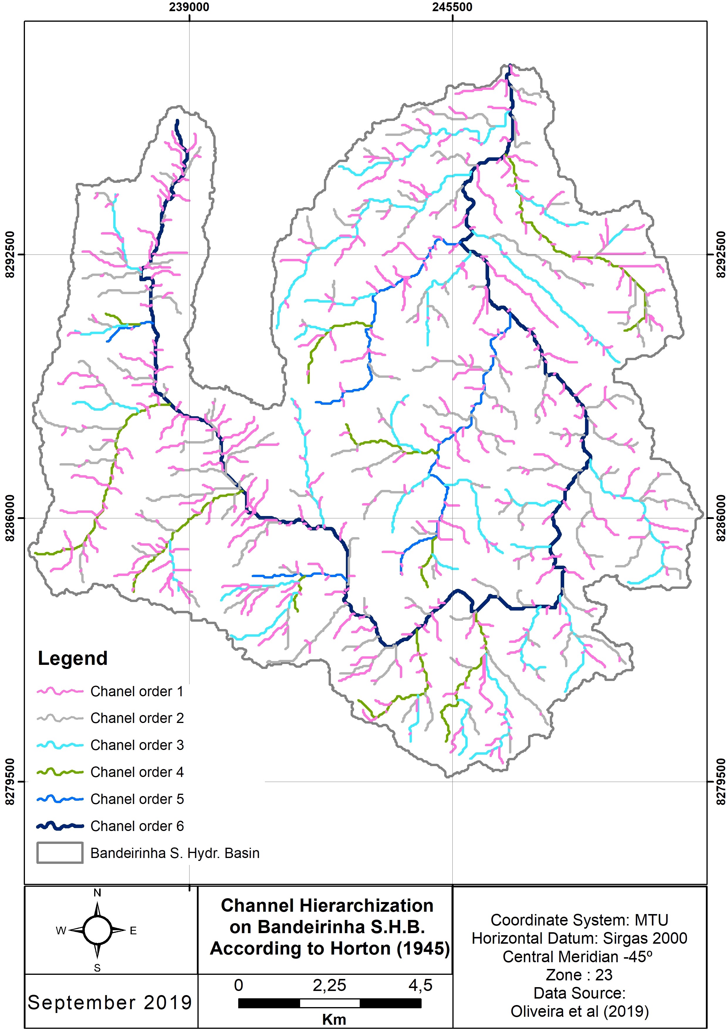
The present research aimed to demonstrate the feasibility of using image segmentation for better drainage extraction, automated drainage network hierarchization and main channel definition based on Horton (1945). The test area for the applications was the Bandeirinha Stream Hydrographic Basin (BSHB), which is located in the municipality of Formosa, in the state of Goiás, Brazil. The study used the Shuttle Radar Topography Mission (SRTM), with a spatial resolution of 1" x 1" (one arc second). The SRTM segmentation was performed using the Python language ODR_Obia algorithm, inserted with a QGIS plugin. Through the QGIS platform, the ODR_Hidro plugin was used to perform the delimitation of the BSHB, the extraction of the drainages and the definition of the main channel. The results were validated in the field and evaluated from the manual definition of the main channel. That was done using both the data produced by the application and the drainage data contained in the vector base of the topographic maps of the Army of Geographic Service (AGS), at the scale of 1:100,000 and 1:25,000. From the results obtained, it can be inferred that the ODR_Hidro model used for the delimitation of the BSHB, the automated hierarchization of the drainages and the definition of the main channel from the segmented SRTM image is very efficient. The field validation demonstrated its effectiveness by proving the existence of first-order drainages which are not mapped on the DSG chart at a scale of 1:100.000. This leads to the conclusion that the use of the proposed tools and the inclusion of image segmentation, aiming for the extraction of drainage network and geomorphometric characterization of watersheds, can efficiently contribute to the provision of morphometric data.
References
BAATZ, M.; SCHÄPE, A. Multiresolution segmentation: an optimization approach for high quality multi- scale image segmentation. In: XII Angewandte Geographische Informationsverarbeitung, AGIT Symposium. Proceedings... Karlsruhe, Alemanha: Herbert Wichmann, 2000, p. 12-23.
BERTOLINI, W.Z.; DEODORO, S.C.; ZAMBOT, N. Análise morfométrica do relevo da região hidrográfica da Várzea – Alto Rio Uruguai (RS). Revista Geociências. v. 40, p. 83-99, 2021.
BIGARELLA, J. J.; ALESSI, A. H.; BECKER, R. D.; DUARTE, G. M. Natureza dos sedimentos de fundo das baías de Paranaguá e Antonina. Rev. Instituto de Biologia e Pesquisas Tecnológicas, v.15, p.30-33, 1970.
BRIERLEY, G. J., FRYIRS, K. A., MARÇAL, M. S., LIMA, R. N. S. The use of the river styles framework as a tool to ‘work with nature’ in managing rivers in Brazil: examples from the macaé catchment. Revista Brasileira de Geomorfologia, v.20, n. 4, p. 751-771, 2019. https://doi.org/10.20502/rbg.v 20i4.1559
CAVALLI, M.; TREVISANI, S.; COMITI, F.; MARCHI, L. Geomorphometric assessment of spatial sediment connectivity in small Alpine atchments. Geomorphology, v. 188, p. 31-41, 2013. https://doi.org/10.1016/j.geomorph.2012.05.007.
CHRISTOFOLETTI, A. Geomorfologia. 2. ed. 14. imp. São Paulo: Edgard Blücher, 1980, p. 188.
CHRISTOFOLETTI, A. Morfologia de bacias de drenagem. Notícias Geomorfológicas, Campinas, v. 18, n. 36, 1978, p. 130-142.
CUNHA, T. C. F. Investigação genética de casos de deficiência intelectual em populações consanguíneas do sertão paraibano. 2015. 76 f. Tese (Doutorado em Biotecnologia) - Rede Nordeste de Bioteconologia, João Pessoa, 2015. Available: https://repositorio.ufpb.br/jspui/ handle/tede/9816. Access on: Jan. 8, 2019.
DAVIS, W. M. The Geomorphic Cycle. Geomorphic J, v. 14, p. 481-504, 1899. https://doi.org/10.2307/1774538
DOUBRAWA, B.; SANQUETTA, C. R.; DALLA CORTE, A. P.; KLEIN HENTZ, Â. M. Remoção de CO2 associada à dinâmica da cobertura florestal na bacia hidrográfica do rio Iguaçu no período 2000-2010. Interciencia, v. 39, n. 8, 2014.
FERNÁNDEZ, D. C. J.; MORISSON VALERIANO, M.; ZANI, H.; OLIVEIRA ANDRADES FILHO, C.. Extração automática de redes de drenagem a partir de modelos digitais de elevação. Revista Brasileira de Cartografia, v. 64n. 3, 2012. https://doi.org/10.14393/rbcv64n6-43808
FERREIRA, R. D. S.; COSTA, G. A.; FEITOSA, R. Q. Avaliação de critérios de heterogeneidade baseados em atributos morfológicos para segmentação de imagens por crescimento de regiões. Boletim de Ciências Geodésicas, v. 19, n. 3, 2013. https://doi.org/10.1590/S1982-21702013000300007.
FRYIRS, K. A., BRIERLEY, G. J., MARÇAL, M., PEIXOTO, M. N., LIMA, R. Learning, Doing and Professional Development – The River Styles Framework as a Tool to Support the Development of Coherent and Strategic Approaches for Land and Water Management in Brazil. Revista Brasileira de Geomorfologia, v. 20, n.4, p. 773-794, 2019. https://doi.org/10.20502/rbg.v20i4.1560.
HORTON, R. E. Erosinal development of streams and their drainage basin: hydrophysical approach to quantitative morphology. Geol. Soc America Bulletin, v. 3, n. 56, 1945. https://doi.org/10.1130/0016-7606(1945)56[275:EDOSAT]2.0.CO;2
KONDOLF, G. M., PIEGAY, H.. Tools in Fluvial geomorphology: problem Statement and Recent practice – In: Tools in Fluvial geomorphology. 2 ed. John Wiley & Sons, Nova Jersey, 2016. https://doi.org/10.1002/9781118648551.ch1.
LATRUBESSE, E.; CARVALHO, T. M. Geomorfologia de Goiás e Distrito Federal. Superintendência de Geologia e Mineração - Série Geologia e Mineração, v. 2, 2006.
LAVOR, L.F.; LIMA, V.F.; ARAÚJO, M.E.; Neumann, V. H. M. L. Geomorfologia da porção terminal do baixo curso do Rio Paraíba do Norte -PB. Revista de Geociências do Nordeste [online] v. 6, 2020. Disponível: https://doi.org/10.21680/2447-3359.2020v6n2ID18685.
LEAL, M. S. & TONELLO, K. C. Análise Morfometria e do Uso e Cobertura da Terra da Microbacia do Córrego Ipaneminha de Baixo, Sorocaba/SP. Floresta, v. 46, n. 4, p. 439-446, 2016. https://doi.org/10.5380/rf.v46i4.45809.
LEITE, M. E.; ALMEIDA, J. W. L.; DA SILVA, R. F.. Geotecnologias aplicadas à extração automática de dados morfométricos da bacia do Rio Pacuí/MG. Revista brasileira de cartografia, v. 64, n. 3, 2012. https://doi.org/10.14393/rbcv64n6-43812
LEOPOLD, L .B.; WOLMAN, M.G. River Channel Patterns, Braided, Meandering and Straight. U.S. Geol. Surv. 282-B, 1957. https://doi.org/10.3133/pp282B
MAGALHÃES, C. S.; RODRIGUES, S. C. A aplicação de parâmetros morfométricos no estudo do relevo das bacias do Rio Santo Antônio e Ribeirão Grande, Serra da Canastra, Sudoeste de Minas Gerais. Caderno de Geografia, v 30, n especial 1, 2020. https://doi.org/10.5752/P.2318-2962.2020v30nesp1p136-153
MAKSOUD, H.; O estado atual dos conhecimentos sobre os recursos de água do Nordeste. Revista Brasileira de Geografia, 1961.
MARÇAL, M. S., BRIERLEY, G., LIMA, R. Using geomorphic understanding of catchment-scale process relationships to support the management of river futures: Macaé basin, Brazil. Applied Geography, v. 84, p. 23-41, 2017. https://doi.org/10.1016/j.apgeog.2017.04.008
MARTINS, L. P.; MATTOS, P. P.; BRAZ, E. M. Crescimento de Eugenia Dysenterica (Mart.) DC no Bioma Cerrado, Formosa, GO. Colombo, PR: Embrapa Florestas, p. 5, 2015. Available: https://www.infoteca.cnptia.embrapa.br/infoteca/handle/doc/1038578. Access on: Sep. 25, 2020.
OLIVEIRA, O. A. Análise de técnicas de segmentação para melhoria na obtenção de dados geomorfométricos com base em ferramentas open source. 2019. Dissertação (Mestrado em Geoprocessamento e Análise Ambiental). Available: https://repositorio.unb.br/handle/10482/35770. Access on: Sep. 25, 2020.
OLIVEIRA, O. A.; ALMEIDA TEIXEIRA, T. M.; PASSO, D. P. Mapeamento dos Conflitos de Uso da Terra em Áreas de Preservação Permanente dos Rios que Contribuem para o Barramento do Rio Paranã, Formosa-GO. Boletim Goiano de Geografia, v. 38, n. 3, p. 491-515, 2018. https://doi.org/10.5216/bgg.v38i3.56348.
OLIVEIRA, O. A.; BIAS, E. S.; STEINKE, V. A.; SOUSA, R. B.; PASSO, D. P.; BAPTISTA, G. M. M.; FILHO, P. F. Análise de técnicas de segmentação para melhoria na obtenção de dados geomorfométricos com base em ferramentas open source. Revista Brasileira de Geomorflogia, v. 21, n. 4), p. 797-820, 2020. http://dx.doi.org/10.20502/www.ugb.org.br rbg.v21i4.1658
PADILHA, R. M.; SOUZA, C. A. Características morfométricas do relevo e drenagem da bacia hidrográfica do Rio Carapá nos municípios de Colíder e Nova Canaã do Norte–MT. Os Desafios da Geografia Física na Fronteira do Conhecimento, v. 1, p. 52-63, 2017. https://doi.org/10.20396/sbgfa.v1i2017.1777
PIMENTA, S. M.; BOAVENTURA, G. R.; RIBEIRO, T. G.; PEÑA, A. P. Estudo dos Sedimentos da Corrente em Drenagens Inseridas na Área Rural e na Área Urbana do Município de Formosa-GO. Revista de Ciências Ambientais, v. 9, n. 2, p-87, 2015b . https://doi.org/10.18316/1981-8858.13.
PIMENTA, S. M.; BOAVENTURA, G. R.; RIBEIRO, T. G.; PEÑA, A. P.. Qualidade da Água e Correlação de Parâmetros Físico-Químicos em Drenagens Urbana e Rural de Formosa (GO). Revista Ibero-Americana de Ciências Ambientais, v. 6, n. 1, p. 78-94, 2015a. https://doi.org/10.6008/SPC2179-6858.2015.001.0007.
ROMSTAD, B. & ETZELMÜLLER, B. Structuring the digital elevation model into landform elements through watershed segmentation of curvature. Proceedings of Geomorphometry, v. 31, 55, 2009.
SANTOS, A. P.; MEDEIROS, N. G. SANTOS, G. R.; RODRIGUES, D. D. (2015). Controle de qualidade posicional em dados espaciais utilizando feições lineares. Boletim de Ciências Geodésicas, v. 21, n 2, p. 233-250. http://dx.doi.org/10.1590/S1982-217020150002000013
SCHEREN, R. S., & ROBAINA, L. E. de S. Classificação geomorfométrica da bacia hidrográfica do rio Ijuí, RS. Geografia Ensino & Pesquisa, v. 23, e1, 2019. https://doi.org/10.5902/2236499430262.
SCHUMM, S. A. Sinuosity of alluvial rivers on the Great Plains. Geological Society of America Bulletin, v. 74, n. 9, p. 1089-1100, 1963. https://doi.org/10.1130/0016-7606(1963)74[1089:SOAROT]2.0.CO;2
SIEG. Sistema Estadual de Geoinformação de Goiás. 2019. Available: http://www.sieg.go.gov.br/. Access on: Dec. 15, 2019.
SILVA, B.F.; SILVEIRA, A.; BARBOSA, M.I.M. Cartografia Geomorfológica Aplicada à bacia hidrográfica do Ribeirão do Brejão, município de Nova Ponte (MG): Indicativos da evolução do relevo e contribuições ao planejamento. Revista Brasileira de Cartografia [online] v. 72, 2020. https://doi.org/10.14393/rbcv72n3-53365.
SOBRINHO, T. A.; OLIVEIRA, P. T. S.; RODRIGUES, D. B. B.; AYRES, F. M. Delimitação automática de bacias hidrográficas utilizando dados SRTM. Revista engenharia agrícola, Jaboticabal, v. 30, n. 1, p. 46-57, 2010. https://doi.org/10.1590/S0100-69162010000100005.
TARBOTON, D. G. A new method for the determination of flow directions and upslope areas in grid digital elevation models. Water resources research, v. 33, n. 2, p. 309-319, 1997. https://doi.org/10.1029/96WR03137.
TRENTIN, R.; ROBAINA, L.E.S.; SILVEIRA, C.T., 2015.Compartimentação geomorfométrica da bacia hidrográfica do Rio Itú/RS. Revista Brasileira de Geomorfologia [online]. v. 16. http://dx.doi.org/10.20502/rbg.v16i2.460.
WANG, L. & LIU, H. An efficient method for identifying and filling surface depressionsin digital elevation models for hydrologic analysis and modelling. International Journal of Geographical Information Science, v.20, n. 2, p. 193-213, 2006. https://doi.org/10.1080/13658810500433453.

This work is licensed under a Creative Commons Attribution 4.0 International License.
Copyright (c) 2022 Olavo Amancio Oliveira, Edilson Souza Bias, Valdir Adilson Steinke