
Keywords
Remote sensing
Amazon Forest
Composite image
How to Cite


Abstract
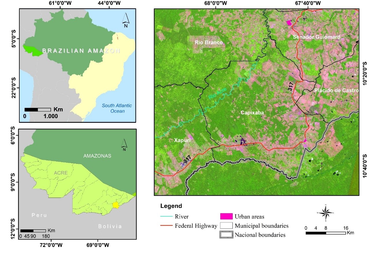
One challenge in the study of optical remotely sensed time series in the Amazon is the constant cloud cover. The present study evaluates different compositing techniques using regular and non-regular intervals to obtain cloud-free images over large areas. The study area was the municipality of Capixaba in the State of Acre, belonging to the Amazon region. The tests considered four compositing algorithms (maximum, minimum, mean, and median) for daily MODIS sensor data (b1 and b2, 250m). The compositing technique from regular intervals adopted the following periods: 8, 16, 24, 32, 40, and 48 days. The irregular interval composite images adopted different composition intervals for dry seasons (April to September) and rainy (October to March). The cloud mask and viewing angle constraint allowed to obtain information without atmospheric interference and closest to nadir view. The composite images using regular intervals did not allow to overcome the high frequency of cloud cover of the region. The composite images from non-regular intervals presented a higher percentage of cloud-free pixels. The mean and median methods provided the better visual appearance of the images, corroborating with the homogeneity test. Therefore, composite images from non-regular intervals may be an appropriate alternative in places with constant cloud coverage.
References
AB’SÁBER, A. Os domínios de natureza no Brasil: potencialidades paisagísticas. [The domains of nature in Brazil: landscape potential] 12th ed. São Paulo: Ateliê Editorial, 2003.
ASNER, G. P. 2001. Cloud cover in Landsat observations of the Brazilian Amazon. International Journal of Remote Sensing, v. 22, p. 3855–3862, 2001. https://doi.org/10.1080/01431160010006926
ASNER, G. P.; ALENCAR, A. Drought impacts on the Amazon Forest: the remote sensing perspective, New Phytologist, v.187, p. 569–578, 2010. https://doi.org/10.1111/j.1469-8137.2010.03310.x
BARBOSA, P. M.; PEREIRA, J. M. C.; GRÉGOIRE, J. -M. Compositing Criteria for burned area assessment using multitemporal low resolution satellite data. Remote Sensing of Environment, v. 65, p. 38–49, 1998. https://doi.org/10.1016/S0034-4257(98)00016-9
BARNES, W. L.; PAGANO, T. S.; SALOMONSON, V. V. Prelaunch characteristics of the Moderate Resolution Imaging Spectroradiometer (MODIS) on EOS-AM1. IEEE Transactions on Geoscience and Remote Sensing, v. 36, p. 1088–1100, 1998. https://doi.org/10.1109/36.700993
BI, J. et al. Amazon Forests’ response to droughts: a perspective from the MAIAC product. Remote Sensing, v. 8, p. 356, 2016. https://doi.org/10.3390/rs8040356
CAHOON, D. R. et al. Satellite analysis of the severe 1987 forest fires in northern China and southeastern Siberia. Journal of Geophysical Research: Atmospheres, v. 99, p. 18,627–18,638, 1994. https://doi.org/10.1029/94JD01024
CHEN, Y. et al. An evaluation of MODIS daily and 8-day composite products for floodplain and wetland inundation mapping. Wetlands, v. 33, p. 823–835, 2013. https://doi.org/10.1007/s13157-013-0439-4
CHUVIECO, E. et al. Assessment of multitemporal compositing techniques of MODIS and AVHRR images for burned land mapping. Remote Sensing of Environment, v. 94, p. 450–462, 2005. https://doi.org/10.1016/j.rse.2004.11.006
CHUVIECO, E. et al. Global burned-land estimation in Latin America using MODIS composite data. Ecological Applications, v. 18, p. 64–79, 2008. https://doi.org/10.1890/06-2148.1
CIHLAR, J.; MANAK, D.; D’LORIO, M. Evaluation of compositing algorithms for AVHRR data over land. IEEE Transactions on Geoscience and Remote Sensing, v. 32, p. 427–437, 1994. https://doi.org/10.1109/36.295057
DAAC, N. L. P.; FALLS, S. MODIS Land products quality assurance tutorial: Part-1. Sioux Falls (SD): USGS EROS Center, p. 1–17, 2014.
DALDEGAN, G. A. et al. Spatial patterns of fire recurrence using remote sensing and GIS in the Brazilian Savanna: Serra do Tombador Nature Reserve, Brazil. Remote Sensing, v. 6, p. 9873–9894, 2014. https://doi.org/10.3390/rs6109873
DUARTE, A. F. 2006. Aspectos da climatologia do Acre, Brasil, com base no intervalo 1971-2000 [Aspects of the climatology of Acre, Brazil, based on the interval 1971-2000]. Revista Brasileira de Meteorologia, v. 21, p. 308–317, 2006.
DWYER, J.; SCHMIDT, G. 2006. The MODIS Reprojection Tool. In: Qu, J. J. et al. (Editors). Earth sciencesatelliteremotesensing. Berlin: Springer, 2006. p. 162–177. https://doi.org/10.1007/978-3-540-37294-3_9
FISCH, G.; MARENGO, J. A.; NOBRE, C. A. Uma revisão geral sobre o clima da Amazônia. [A general review on the climate of the Amazon]. Acta Amazônica, v. 28, p. 101–126, 1998. https://doi.org/10.1590/1809-43921998282126
GIGLIO, L.; SCHROEDER, W.; JUSTICE, C. O. The collection 6 MODIS active fire detection algorithm and fire products. Remote Sensing of Environment, v. 178, p. 31–41, 2016. https://doi.org/10.1016/j.rse.2016.02.054
GUINDIN-GARCIA, N. et al. An evaluation of MODIS 8- and 16-day composite products for monitoring maize green leaf area index. Agricultural and Forest Meteorology, v. 161, p. 15–25, 2012. https://doi.org/10.1016/j.agrformet.2012.03.012
HILKER, T. et al. On the measurability of change in Amazon vegetation from MODIS. Remote Sensing of Environment, v. 166, p. 233–242, 2015. https://doi.org/10.1016/j.rse.2015.05.020
HOLBEN, B. N. Characteristics of maximum-value composite images from temporal AVHRR data. International Journal of Remote Sensing, v. 7, p. 1417–1434, 1986. https://doi.org/10.1080/01431168608948945
IBGE - Instituto Brasileiro de Geografia e Estatística (BR). Pesquisa de informações básicas municipais - cidades. [Search by basic municipal sources - cities]. 2016. Available: https://cidades.ibge.gov.br/. Accessed on: Dec 15, 2018.
INMET - Instituto Nacional de Meteorologia. BDMEP - Banco de Dados Meteorológicos para Ensino e Pesquisa. [Meteorological Database for Teaching and Research]. 2015. Available: http://www.inmet.gov.br/. Accessed on: Dec 15, 2018.
JUSTICE, C. O. et al. The Moderate Resolution Imaging Spectroradiometer (MODIS): land remote sensing for global change research. IEEE Transactions on Geoscience and Remote Sensing, v. 36, p. 1228–1249, 1998. https://doi.org/10.1109/36.701075
LI, H.; LI, X.; XIAO, P. Impact of sensor zenith angle on MOD10A1 data reliability and modification of snow cover data for the Tarim River Basin. Remote Sensing, v. 8, p. 1–18, 2016. https://doi.org/10.3390/rs8090750
MEYER, D.; VERSTRAETE, M.; PINTY, B. The effect of surface anisotropy and viewing geometry on the estimation of NDVI from AVHRR. Remote Sensing Reviews, v. 12, p. 37–41, 1995. https://doi.org/10.1080/02757259509532272
MIETTINEN, J.; LIEW, S. C. Comparison of multitemporal compositing methods for burnt area detection in Southeast Asian conditions. International Journal of Remote Sensing, v. 29, p. 1075–1092, 2008. https://doi.org/10.1080/01431160701281031
POTTER, C. S.; BROOKS, V. Global analysis of empirical relations between annual climate and seasonality of NDVI. International Journal of Remote Sensing, v. 19, p. 2921–2948, 1998. https://doi.org/10.1080/014311698214352
QI, J.; KERR, Y. On current compositing algorithms. Remote Sensing Reviews, v. 15, p. 235–256, 1997. https://doi.org/10.1080/02757259709532340
SAMANTA, A. et al. Amazon forests did not green-up during the 2005 drought. Geophysical Research Letters, v. 37, p. 1–5, 2010. https://doi.org/10.1029/2009GL042154
SANTANA, N. C. et al. Burned-area detection in amazonian environments using standardized time series per pixel in MODIS data. Remote Sensing, v. 10, p. 1904, 2018. https://doi.org/10.3390/rs10121904
SOUSA, A. M. O.; PEREIRA, J. M. C.; SILVA, J. M. N. Evaluating the performance of multitemporal image compositing algorithms for burned area analysis. International Journal of Remote Sensing, v. 24, p. 1219–1236, 2003. https://doi.org/10.1080/01431160110114466
VAN LEEUWEN, W. J. D.; HUETE, A. R.; LAING, T. W. MODIS vegetation index compositing approach: A prototype with AVHRR data. Remote Sensing of Environment, v. 69, p. 264–280, 1999. https://doi.org/10.1016/S0034-4257(99)00022-X
VANCUTSEM, C. et al. An assessment of three candidate compositing methods for global MERIS time series. Canadian Journal of Remote Sensing, v. 33, p. 492–502, 2007a. https://doi.org/10.5589/m07-056
VANCUTSEM, C. et al. Mean Compositing, an alternative strategy for producing temporal syntheses. Concepts and performance assessment for SPOT VEGETATION time series. International Journal of Remote Sensing, v. 28, p. 5123–5141, 2007b. https://doi.org/10.1080/01431160701253212
VANCUTSEM, C.; DEFOURNY, P. A decision support tool for the optimization of compositing parameters. International Journal of Remote Sensing, v. 30, p. 41–56, 2009. https://doi.org/10.1080/01431160802036375
VINTROU, E. et al. Mapping fragmented agricultural systems in the Sudano-Sahelian environments of Africa using random forest and ensemble metrics of coarse resolution MODIS imagery. Photogrammetric Engineering and Remote Sensing, v. 78, p. 839–848, 2012. https://doi.org/10.14358/PERS.78.8.839
WARDLOW, B. D.; KASTENS, J. H.; EGBERT, S. L. Using USDA crop progress data for the evaluation of green up onset date calculated from MODIS 250-meter data. Photogrammetric Engineering & Remote Sensing, v. 72, p. 1225–1234, 2006. https://doi.org/10.14358/PERS.72.11.1225
WOLFE, R. E.; ROY, D. P.; VERMOTE, E. MODIS land data storage, gridding, and compositing methodology: Level 2 grid. IEEE Transactions on Geoscience and Remote Sensing, v. 36, p. 1324–1338, 1998. https://doi.org/10.1109/36.701082
XIAO, X. et al. Landscape-scale characterization of cropland in China using vegetation and Landsat TM images. International Journal of Remote Sensing, v. 23, p. 3579–3594, 2002. https://doi.org/10.1080/01431160110106069
YANG, Z. et al. Vegetation condition indices for crop vegetation condition monitoring. Proceedings of the IEEE International Geoscience and Remote Sensing Symposium; Jul 24-29; Vancouver, BC, Canada. IEEE, p. 3534–3537, 2011. https://doi.org/10.1109/IGARSS.2011.6049984
ZENG, X. et al. Derivation and evaluation of global 1-km fractional vegetation cover data for land modeling. Journal of Applied Meteorology and Climatology, v. 39, p. 826–839, 2000. https://doi.org/10.1175/1520-0450(2000)039<0826:DAEOGK>2.0.CO;2

This work is licensed under a Creative Commons Attribution 4.0 International License.
Copyright (c) 2021 Cristiane Batista Salgado, Osmar Abílio Carvalho Junior, Nickolas Castro Santana, Roberto Arnaldo Trancoso Gomes, Renato Fontes Guimarães, Cristiano Rosa Silva