
Keywords
Geoenvironmental Systems
Mapping
How to Cite


Abstract
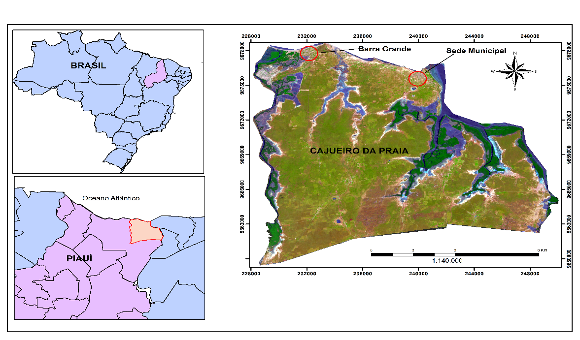
The Brazilian northeast coast has tourism potential, and in the last decades its landscapes have been impacted by the expansion of tourism activity. The present research aimed to survey the change s that occurred in the evolution of soil cover in the municipality of Cajueiro da Praia, Piauí, in 2000 and 2015, using Remote Sensing and Geoprocessing techniques. The supervised classification of images LANDSAT 8 and LANDSAT 5, OLI/TIRS and TM imager instruments, respectively, in 2015 and 2000, using the Maxver method, processed in the Arcgis 10.2 software, made possible the production of the maps of use and coverage and the dynamics of land cover. The analysis identified nine classes of land use and land cover, which showed changes observed from the dynamics between the two dates. The analysis of these data, together with socioeconomic data from the census and surveys carried out by the Brazilian Institute of Geography and Statistics, showed a context of land use and land cover changes, with growth of urban areas, the increase of water bodies of the municipality. The change in the quantitative population of the municipality occurs perceptibly in its coastal area, the increase of water bodies is especially due to the growth of shrimp tanks. The issues of environmental legislation are factors that may explain the recovery of some vegetation areas, as their non-compliance explains the loss of others, such as mangrove vegetation, which was observed throughout the work.
References
ANDRADE-LIMA, D. Vegetação. In: LINS. R. C. Bacia do Parnaíba: aspectos fisiográficos. Recife: Instituto Joaquim Nabuco de Pesquisas Sociais, 1978. 9 v. (Série estudos e pesquisas).
ALBUQUERQUE, A. G. B. M., FREITAS, e. M. N., MOURA-FÉ, M. M., BARBOSA, W. R. A Proteção do Ecossistema Manguezal pela Legislação Ambiental Brasileira. GEOgraphia, v. 17(33), p. 126-153, 2015. https://doi.org/10.22409/GEOgraphia2015.1733.a13700
ARAÚJO, F. S., MARTINS, F. R., e SHEPHERD, G. J. Variações estruturais e florísticas do carrasco no planalto da Ibiapaba, estado do Ceará. Revista Brasileira de Biologia, v. 59(4), p. 663-678, 1999.
BRASIL. (2012a). Lei Federal nº 12.651, de 25 de maio de 2012. Dispõe sobre o Código Florestal. Disponível em: <http://www.planalto.gov.br/ccivil_03/_ato2011-2014/2012/lei/l12651.htm> Acesso: jul. 2020 BRASIL. (2012b). Lei Federal nº 12.727, de 17 de outubro de 2012. Dispõe sobre alterações no Código Florestal.
BAPTISTA, E. M. C. Estudo morfossedimentar dos recifes de arenito da zona litorânea do estado do Piauí, Brasil. Tese (Doutoramento em Geografia) - Florianópolis: UFSC. 2010.
CÂMARA, G.; MEDEIROS, J. S. Geoprocessamento para projetos ambientais. São José dos Campos: INPE, 1996.
CAVALCANTI, A, P.B. Impactos e condições ambientais da zona costeira do Estado do Piauí. (Doutorado em Geografia) - Rio Claro: UNESP. 2000.
CPRM. Mapa Geológico do Estado do Piauí. Teresina: CPRM, 2006.
FONSECA, L. M. G. Processamento digital de imagens. São Paulo: INPE, 2000.
IBGE. Instituto brasileiro de Geografia e Estatística. Censo Demográfico 2010. Disponível em: <http://www.ibge.gov.br/cidadesat/index.php>. Acesso em: 18 fev. 2018.
INMET. Instituto Nacional de Meteorologia. Disponível em: < https://portal.inmet.gov.br/>. Acesso em: 12 jul. 2020.
JENSEN, J. R. Sensoriamento remoto do ambiente: uma perspectiva em recursos terrestres. Tradução da 2ª edição. São José dos Campos: Parêntese, 2009.
MMA. Ministério do Meio Ambiente. Áreas Prioritárias para Conservação, Uso Sustentável e Repartição de Benefícios da Biodiversidade Brasileira: Atualização - Portaria MMA n°9, de 23 de janeiro de 2007. Brasília: MMA, 2007.
______. Ministério do Meio Ambiente. Panorama da conservação dos ecossistemas costeiros e marinhos no Brasil. SBF/GBA, Brasília: MMA, 2010.
______. Avaliação e ações prioritárias para a conservação da biodiversidade da caatinga. Brasília: MMA, 2002.
PERROCA, M. G.; GAIDZINSKI, R. R. Avaliando a confiabilidade interavaliadores de um instrumento para classificação de pacientes - coeficiente Kappa. Rev. Esc. Enferm. USP, vol. 37, p. 72-80, 2003. https://doi.org/10.1590/S0080-62342003000100009
RADAMBRASIL. Série Levantamento de Recursos Naturais. Rio de Janeiro: FIBGE:, 1983. 32 v.
ROSA, R. Introdução ao sensoriamento remoto. 5ª ed. Uberlândia: EDUFU, 2003.
VENTURI, L. A. B. A dimensão territorial da paisagem geográfica. Congresso Brasileiro de Geógrafos, Goiânia, 2004, p. 11.
Authors hold the Copyright for articles published in this journal, and the journal holds the right for first publication. Because they appear in a public access journal, articles are licensed under Creative Commons Attribution (BY), which permits unrestricted use, distribution, and reproduction in any medium, provided the original work is properly cited.