
Keywords
Remote sensing
Urbanization
Coari - AM
How to Cite


Abstract
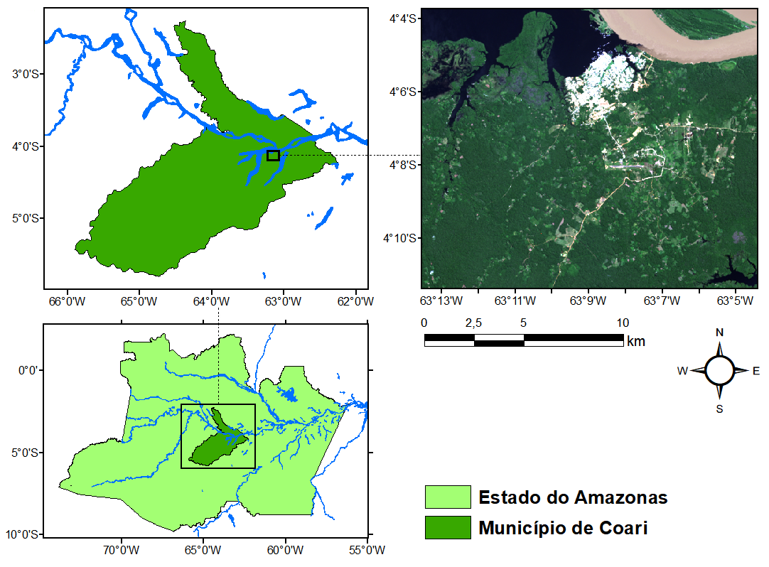
Microclimates are very sensitive to surface cover type. Changes in vegetation cover modify energy distribution patterns, strongly impacting essential variables such as temperature and relative humidity. Regions with high vegetal cover density channel much of the energy through evapotranspiration, thus promoting a tremendous thermo-hydroregulating effect on the environment. The mapping of climatological variables through remote sensing and geoprocessing techniques can help in dimensioning this phenomenon and has become a popular technique due to the high availability of data from orbital satellite images and lower cost. This work uses images from the Landsat 8 satellite from the United States Geological Survey to map vegetation, urbanization and surface temperature in the urban area of Coari, Amazonas - Brazil in two distinct periods (2015 and 2017), seeking a quantitative evaluation of the influence of vegetation and urbanization on the values of this temperature. This study also attempts to estimate the importance of the atmospheric correction for this estimate and the difference in general climate conditions between the dates. The research shows that there is a considerable influence of vegetation on temperature control, despite higher reflective capacity (albedo) of urbanized areas. The urbanized regions showed temperatures up to 7°C higher than densely vegetated regions. Atmospheric correction in the temperature estimation is crucial, otherwise values can be severely underestimated. Temperatures in 2015 were substantially higher on soil regions, but lower in the water bodies, which is counterintuitive . Finally, this study may suggest a greater commitment of the public power in the promotion of policies aimed at the afforestation and vegetation of urban centers.
References
AB'SABER, A. N. Zoneamento fisiográfico e ecológico do espaço total da Amazônia Brasileira. Estud. av., São Paulo, v. 24, n. 68, p. 15-24, 2010. https://doi.org/10.1590/S0103-40142010000100004
ALHAWITI, R. H. e MITSOVA, D. Using Landsat-8 data to explore the correlation between Urban Heat Island and Urban Land uses. International Journal of Research in Engineering and Technology. V. 5, p. 457-466, Março de 2016. https://doi.org/10.15623/ijret.2016.0503083
ALLEN, R. G, TASUMI, M., TREZZA, R. Satellite-based energy balance for mapping evapotranspiration with internalized calibration (METRIC) – Model. Journal of Irrigation and Drainage Engineering. V.133, n.4, p. 380- 394, 2007. https://doi.org/10.1061/(ASCE)0733-9437(2007)133:4(380)
BARSI, J. A.; BARKER, J. L. e SCHOTT J. R. An Atmospheric Correction Parameter Calculator for a Single Thermal Band Earth-Sensing Instrument. Geoscience and Remote Sensing Symposium (Anais), Centre de Congres Pierre Baudis, Toulouse, France, 21-25 de Julho de 2003.
BIUDES, M. S.; VOULITIS, G. L.; MACHADO, N. G.; DE ARRUDA, P.H.Z.; NEVES, G.A.R.; LOBO, F.A.; NEALE, C.M.U.; NOGUEIRA, J.S. Patterns of energy exchange for tropical ecosystems across a climate gradiente in Mato Grosso, Brazil. Agricultural and Forest Meteorology, v. 202, p. 112–124, 2015. https://doi.org/10.1016/j.agrformet.2014.12.008
CARLSON, T. e RIPLEY, D. A. On the relation between NDVI, fractional vegetation cover, and leaf area index. Remote Sensing of Environment. V. 62, p. 241-252, 1997. https://doi.org/10.1016/S00344257(97)00104-1
CHEN, X.; ZHAO, H; LI, P. e YIN, Z. Remote sensing image-based analysis of the relationship between urban heat island and land use/cover changes, Remote Sensing of Environment, V. 104, Issue 2, P. 133-146, 2006. ISSN 0034-4257. https://doi.org/10.1016/j.rse.2005.11.016
DARCAN, N.; GÜNEY, O. Alleviation of climatic stress of dairy goats in Mediterranean climate. Small Ruminant Research. Vol.74, 212-215, 2008. https://doi.org/10.1016/j.smallrumres.2007.02.007
ESPA - EROS Science Processing Architecture On Demand Interface. 2019. Disponível em <https://espa.cr.usgs.gov/>
FEARNSIDE, P. M. Desmatamento na Amazônia: dinâmica, impactos e controle. Acta Amazônica, v. 36(3), p. 395 – 400, 2006. https://doi.org/10.1590/S0044-59672006000300018
FERREIRA, L. V.; VENTICINQUE, E.; ALMEIDA, S. O desmatamento na Amazônia e a importância das áreas protegidas. Estud. av., São Paulo, v. 19, n. 53, p. 157-166, Apr. 2005. https://doi.org/10.1590/S0103-40142005000100010
GAOUA, N.; RACINAIS, S.; GRANTHAM, J.; EL MASSIOUI, F. Alterations in cognitive performance during passive hyperthermia are task dependent. Int. J. Hyperthermia 27, 1–9 (2011) https://doi.org/10.3109/02656736.2010.516305
GARTLAND, L. Ilhas de calor: como mitigar zonas de calor em áreas urbanas. São Paulo: Oficina de Textos, 2010.
GLOVIS - Global Visualization Viewer. The USGS Global Visualization Viewer (GloVis). 2019. Disponível em <https://glovis.usgs.gov/>.
GSFC - NASA's Goddard Space Flight Center. Atmospheric Correction Parameter Calculator. 2019. Disponível em <https://atmcorr.gsfc.nasa.gov/>.
GUILHERME, A. P. et al. USO DE ÍNDICE DE VEGETAÇÃO PARA CARACTERIZAR A MUDANÇA NO USO DO SOLO EM COARI-AM. Soc. nat., Uberlândia, v. 28, n. 2, p. 301-310, ago. 2016. http://dx.doi.org/10.1590/1982451320160209.
INSTITUTO BRASILEIRO DE GEOGRAFIA E ESTATÍSTICA – IBGE [internet]. Acesso em 24 de novembro de 2013. Disponível em: http://cidades.ibge.gov.br/painel/painel.php?codmun=130120. 2011
INSTITUTO NACIONAL DE PESQUISAS ESPACIAIS/ CENTRO DE PREVISÃO DE TEMPO E ESTUDOS CLIMÁTICOS. Impactos do fenômeno ENOS, 2016. Disponível em: http://enos.cptec.inpe.br. Acesso em 23 dez. 2016.
JENKS, G. F. The Data Model Concept in Statistical Mapping. International Yearbook of Cartography. V. 7, P. 186–190. 1967.
MADER T.L.; JOHNSON L.J.; GAUGHAN, J.B. A comprehensive index for assessing environmental stress in animals. Journal of Animal Science. Vol. 88, 2153-2165, 2010. https://doi.org/10.2527/jas.2009-2586
MCMORRIS, T. et al. Heat stress, plasma concentrations of adrenaline, noradrenaline, 5-hydroxytryptamine and cortisol, mood state and cognitive performance. Int. J. Psychophysiol. 61, 204-215 (2006). https://doi.org/10.1016/j.ijpsycho.2005.10.002
MEDEIROS, S. S.; CECÍLIO, R. A.; MELO JÚNIOR, J. C. F. Estimativa e espacialização das temperaturas do ar mínimas, médias e máximas na Região Nordeste do Brasil. Revista Brasileira de Engenharia Agrícola e Ambiental, v. 9, n. 2, p. 247-255, 2005.https://doi.org/10.1590/S141543662005000200016
MOURÃO, G. M. N. Colonización reciente y asentamientos rurales en el sureste de Roraima, Amazonia Brasileña: entre la política y la naturaleza. 2003. 480 f. Tese de doutorado, Universidad de Valladolid, Espanha. 2003.
PAVAO, V. M. et al. Impacto da Conversão da Cobertura Natural em Pastagem e Área Urbana sobre Variáveis Biofísicas no Sul do Amazonas. Rev. bras. meteorol. V. 32, n. 3, p. 343-351, set. 2017. http://dx.doi.org/10.1590/0102-77863230002.
PRICE, J. C. Estimating surface temperatures from satellite thermal infrared data - a simple formulation for the atmospheric effect. Remote Sens. Environ. V. 13, p. 353-361, 1983. https://doi.org/10.1016/0034-4257(83)90036-6
SANTOS, U. M.; RIBEIRO, M. N. G. A hidroquímica do Rio Solimões - Amazonas. Acta Amaz. Manaus, v. 18, n. 3-4, p. 145-172, 1988 https://doi.org/10.1590/1809-43921988183172
SHALABY, A. E.; TATEISHI, R. Remote sensing and GIS for mapping and monitoring land cover and land-use changes in the Northwestern coastal zone of Egypt, Applied Geography, V. 27, Issue 1, 2007, Pages 28-41, ISSN 0143-6228. https://doi.org/10.1016/j.apgeog.2006.09.004
SILVA, B. B.; BRAGA, A. C.; BRAGA, C. C.; OLIVEIRA, L. M. M.; MONTENEGRO, S. M. G. L.; BARBOSA JUNIOR, B. Procedures for calculation of the albedo with OLI-Landsat 8 images: Application to the Brazilian semi-arid. Revista Brasileira de Engenharia Agrícola e Ambiental. v.20, n.1, p.3–8, 2016. http://dx.doi.org/10.1590/1807-1929/agriambi.v20n1p3-8
STERN, N. The structure of economic modeling of the potential impacts of climate change: Grafting gross underestimation of risk onto already narrow science models. J. Econ. Lit. 51, 838–859 (2013). https://doi.org/10.1257/jel.51.3.838
TAMM, M. et al. The compression of perceived time in a hot environment depends on physiological and psychological factors. Q. J. Exp. Psychol. 67, 197–208 (2014). https://doi.org/10.1080/17470218.2013.804849
TAWATSUPA, B. et al. Association between heat stress and occupational injury among Thai workers: Findings of the Thai cohort study. Ind. Health 51, 34–46 (2013). https://doi.org/10.2486/indhealth.2012-0138
TUCKER, C. J. Red and photographic infrared linear combinations for monitoring vegetation. Remote Sens. Environ. V. 8, P. 127–150. 1979 https://doi.org/10.1016/0034-4257(79)90013-0
USGS – United States Geological Survey. Landsat 8 Data Users Handbook. Edição digital. Versão 2.0. Março de 2016. Disponível em <https://landsat.usgs.gov/sites/default/files/documents/Landsat8DataUsersHandbook.pdf>.
VALOR, E.; CASELLES Vicente. Mapping Land Surface Emissivity from NDVI: Application to European, African, and South American Areas. Remote Sensing of Environment. V. 57, p. 167-184. 1996. https://doi.org/10.1016/0034-4257(96)00039-9
VAREJÃO-SILVA, M.A. Meteorologia e Climatologia. Versão digital 2. Recife, PB, março, 2006, 463p.
ZANDER, K. K. et al. Heat stress causes substantial labour productivity loss in Australia. Nature Climate Change. v. 5, pages 647–651 (2015). https://doi.org/10.1038/nclimate2623
Authors hold the Copyright for articles published in this journal, and the journal holds the right for first publication. Because they appear in a public access journal, articles are licensed under Creative Commons Attribution (BY), which permits unrestricted use, distribution, and reproduction in any medium, provided the original work is properly cited.