
Palavras-chave
Métricas abióticas
Autocorrelação espacial bivariada (LISA)
Índice de geodiversidade
Planejamento territorial
Como Citar




Resumo
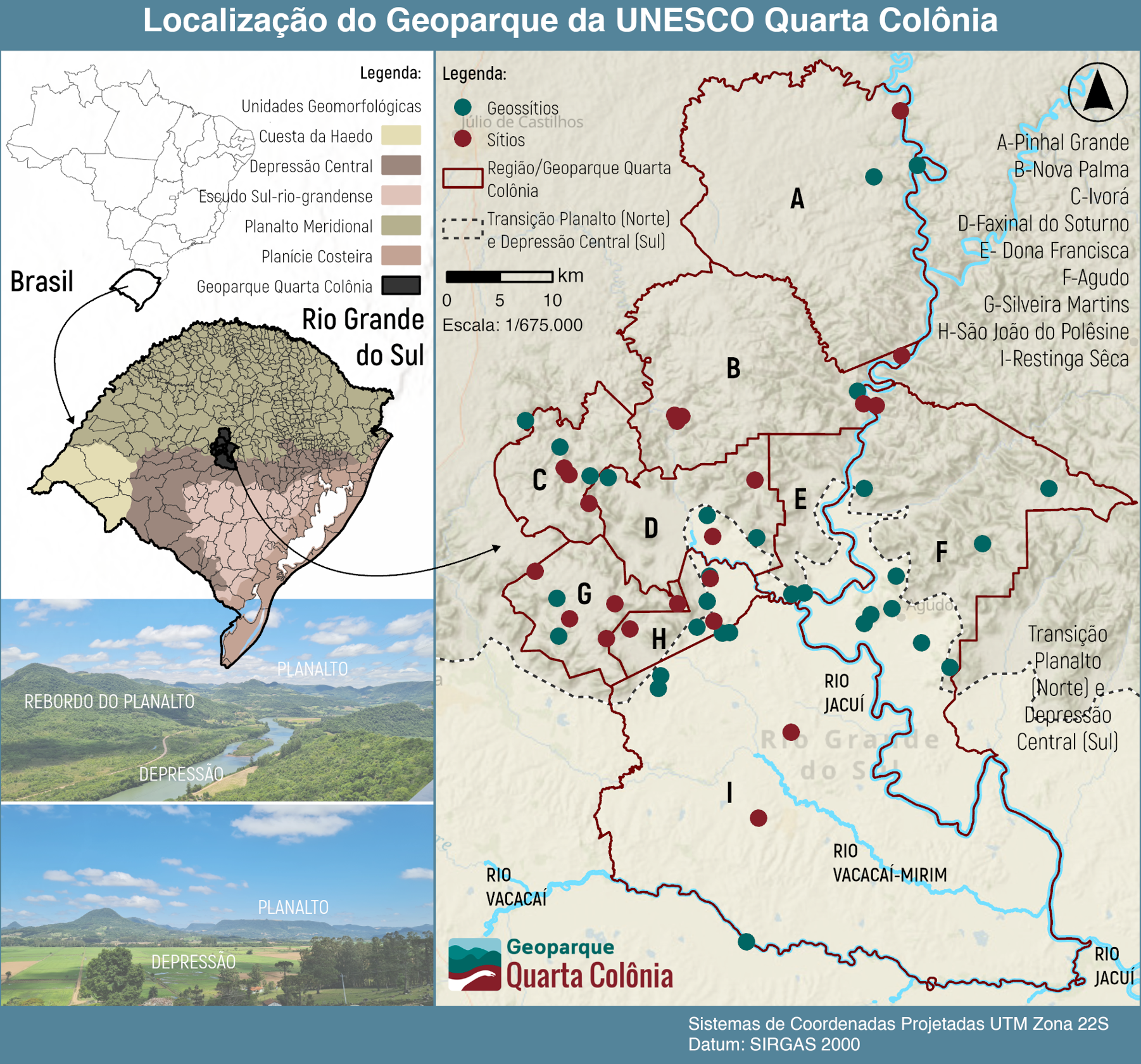
A geodiversidade pode ser compreendida como a base estrutural das paisagens, desempenhando papel significativo na influência de processos ecológicos e na organização espacial dos usos do solo. Em territórios reconhecidos como geoparques, a análise das relações espaciais entre a heterogeneidade abiótica e a ocupação territorial tende a subsidiar estratégias de gestão territorial. Este artigo objetiva quantificar a consistência estatística interna dos componentes físicos da paisagem e investigar suas associações espaciais com os padrões de uso e cobertura da terra no Geoparque Mundial da UNESCO Quarta Colônia (Rio Grande do Sul, Brasil). A metodologia baseou-se na aplicação de uma grade regular de 2 × 2 km como unidade espacial, na qual construiu-se um Índice de Geodiversidade a partir da riqueza de classes geológicas, geomorfológicas, pedológicas e hidrográficas. Os padrões de ocupação antrópica foram analisados sob dois cenários métricos: a riqueza composicional de classes de uso (arranjos multipart) e a fragmentação espacial (arranjos singlepart), representada pelo número de manchas. As relações entre as variáveis foram mensuradas por meio da correlação de Spearman e da Autocorrelação Espacial Local Bivariada (LISA). Os resultados indicam expressiva correlação positiva entre os componentes da geodiversidade, especialmente entre geologia, geomorfologia e pedologia, suportando a consistência metodológica do índice. Observa-se que zonas com maior diversidade abiótica tendem a apresentar maior riqueza composicional de usos, enquanto métricas de fragmentação demonstram menor dependência estatística da estrutura físico-natural. A modelagem espacial (LISA) identificou zonas de coocorrência e de contraste estatístico entre a heterogeneidade física e a intensidade de uso. Conclui-se que a integração entre métricas abióticas, princípios de ecologia da paisagem e estatística espacial viabiliza interpretações quantitativas com potencial de aplicação subsidiária em instrumentos de planejamento territorial em geoparques.
Referências
ANSELIN, L. Local indicators of spatial association – LISA. Geographical Analysis, v. 27, n. 2, p. 93–115, 1995. https://doi.org/10.1111/j.1538-4632.1995.tb00338.x
ANSELIN, L. GeoDa: an introduction to spatial data analysis. Geographical Analysis, v. 38, n. 1, p. 5–22, 2005. https://doi.org/10.1111/j.0016-7363.2005.00671.x
ANSELIN, L.; SYABRI, I.; KHO, Y. GeoDa: An Introduction to Spatial Data Analysis (Version 1.22.0.4) [Software]. GeoDa Center, 2024. Disponível em: https://geodacenter.github.io/. Acesso em: 15 ago. 2025
BRASIL. Lei nº 12.651, de 25 de maio de 2012. Dispõe sobre a proteção da vegetação nativa. Diário Oficial da União, Brasília, DF, 28 maio 2012. Disponível em: https://www.planalto.gov.br/ccivil_03/_ato2011-2014/2012/lei/l12651.htm. Acesso em: 17 ago. 2025.
BRILHA, J. Inventory and quantitative assessment of geosites and geodiversity sites: a review. Geoheritage, v. 8, n. 2, p. 119-134, 2016.
https://doi.org/10.1007/s12371-014-0139-3
CHAKRABORTY, A.; GRAY, M. A call for mainstreaming geodiversity in nature conservation research and praxis. Journal for Nature Conservation, v. 56, p. 1–5, 2020. https://doi.org/10.1016/j.jnc.2020.125862
CIHLAR, J.; JANSEN, L. J. M. From land cover to land use: a methodology for efficient land use mapping over large areas. The Professional Geographer, v. 53, n. 2, p. 275–289, 2001. https://doi.org/10.1111/0033-0124.00285
COHEN, J. Statistical power analysis for the behavioral sciences. 2. ed. Hillsdale, NJ: Lawrence Erlbaum Associates, 1988.
CRESSIE, N. Statistics for spatial data. New York: Wiley, 1993.
https://doi.org/10.1002/9781119115151
DANESE, M.; GIOIA, D.; AMODIO, A. M.; CORRADO, G.; SCHIATTARELLA, M. A spatial method for the geodiversity fragmentation assessment of Basilicata Region, Southern Italy. In: GERVASI, O. et al. (Org.). Computational Science and Its Applications – ICCSA 2021. Cham: Springer, 2021. p. 620–631. https://doi.org/10.1007/978-3-030-86970-0_43
DATTA, K. Does geodiversity correlate with land use/land cover diversity? A case study of Birbhum district, West Bengal, India. Proceedings of the Geologists’ Association, v. 133, n. 6, p. 589–602, 2022. https://doi.org/10.1016/j.pgeola.2022.07.004
DE OLIVEIRA LOPES, Â. L.; BARTZ SCHWANZ, V.; HECK SIMON, A. L. Uso da terra e ameaças à geodiversidade no Bioma Pampa brasileiro. Revista Brasileira de Geografia Física, v. 17, n. 6, p. 4156–4176, 2024. https://doi.org/10.26848/rbgf.v17.6.p4156-4176
ESMAILI, R. Quantitative evaluation and spatial clustering of geodiversity in Iran. Geoheritage, v. 16, n. 13, 2024. https://doi.org/10.1007/s12371-024-00914-4
FERNÁNDEZ, G.; GUERRERO, M.; JACINTO, G.; NOGAR, G.; VALENZUELA, S.; POSADA, M. Degradación ambiental, agricultura y decisiones productivas: un estudio de un área de la pampa argentina. Sociedade & Natureza, v. 9, n. 17, 2021. https://doi.org/10.14393/SN-v9-1997-61177
FORMAN, R. T. T.; GODRON, M. Landscape ecology. New York: John Wiley & Sons, 1986.
FORMAN, R. T. T. Land Mosaics: The Ecology of Landscapes and Regions. Cambridge: Cambridge University Press, 1995. https://doi.org/10.1017/9781107050327
FORTE, J. P.; BRILHA, J.; PEREIRA, D. I.; NOLASCO, M. Kernel density applied to the quantitative assessment of geodiversity. Geoheritage, v. 10, p. 205–217, 2018. https://doi.org/10.1007/s12371-018-0282-3
GOMES, M; FERREIRA, R. L.; RUCHKYS, Ú. A. Landscape evolution in ferruginous geosystems of the Iron Quadrangle, Brazil: a speleological approach in a biodiversity hotspot. Discover Applied Sciences v. 1, n. 9, p. 1-13, set. 2019. https://doi.org/10.1007/s42452-019-1139-3
GOMES, M.; RUCHKYS, Ú. A.; FERREIRA, R. L.; GOULART, F. F. Landscape Fragmentation around Ferruginous Caves of the Iron Quadrangle, Minas Gerais, Brazil. Cuadernos de Geografía: Revista Colombiana de Geografía, v. 28, n. 1, p. 89–101, 2019. https://doi.org/10.15446/rcdg.v28n1.67506
GREGORIO, A. D. Land cover classification system: classification concepts. Rome: FAO, 2016.
GRAY, M. Other nature: geodiversity and geosystem services. Environmental Conservation, v. 38, n. 3, p. 271–274, 2011. https://doi.org/10.1017/S0376892911000117
GRAY, M. Geodiversity: valuing and conserving abiotic nature. 2. ed. Chichester: Wiley-Blackwell, 2013.
GUERINI, M.; MANTOVANI, A.; KHOSO, R. B.; GIARDINO, M. Exploring the correlation between geoheritage and geodiversity through comprehensive mapping. Geomorphology, v. 461, 109298, 2024. https://doi.org/10.1016/j.geomorph.2024.109298
HJORT, J.; LUOTO, M. Can geodiversity be predicted from space? Geomorphology, v. 153–154, p. 74–80, 2012. https://doi.org/10.1016/j.geomorph.2012.02.010
HJORT, J.; GORDON, J. E.; GRAY, M.; HUNTER, M. L. Why geodiversity matters in valuing nature’s stage. Conservation Biology, v. 29, n. 3, p. 630–639, 2015. https://doi.org/10.1111/cobi.12510
IBGE – Instituto Brasileiro de Geografia e Estatística. Consulta geomorfologia. BDIA Web. 2023. Disponível em: https://bdiaweb.ibge.gov.br/#/consulta/geomorfologia. Acesso em: 20 ago. 2025.
JAČKOVÁ, K.; ROMPORTL, D. The relationship between geodiversity and habitat richness in Šumava National Park and Křivoklátsko PLA. Journal of Landscape Ecology, v. 1, n. 1, p. 23–38, 2008. https://doi.org/10.2478/v10285-012-0003-6
LOPES, C.; TEIXEIRA, C.; PEREIRA, D. I.; PEREIRA, P. Identifying optimal cell size for geodiversity quantitative assessment. Resources, v. 12, n. 6, art. 65, 2023. https://doi.org/10.3390/resources12060065
MANOSSO, F. C.; ZWOLIŃSKI, Z.; NAJWER, A.; BASSO, B. T.; SANTOS, D. S.; PAGLIARINI, M. V. Spatial pattern of geodiversity assessment in the Marrecas River drainage basin, Paraná, Brazil. Ecological Indicators, v. 126, 107703, 2021. https://doi.org/10.1016/j.ecolind.2021.107703
MAPBIOMAS. Coleção 10 dos Mapas Anuais de Cobertura e Uso da Terra do Brasil. São Paulo: MapBiomas, 2024. Disponível em: https://brasil.mapbiomas.org/colecoes-mapbiomas/. Acesso em: 17 ago. 2025.
MCGARIGAL, K.; MARKS, B. J. FRAGSTATS: spatial pattern analysis program for quantifying landscape structure. Portland: USDA Forest Service, 1995.
https://doi.org/10.2737/PNW-GTR-351
PÁL, M.; ALBERT, G. From geodiversity assessment to geosite analysis – Bakony-Balaton UNESCO Global Geopark. Geological Society, London, Special Publications, v. 530, n. 1, 2023. https://doi.org/10.1144/sp530-2022-126
PEREIRA, D. I.; PEREIRA, P.; BRILHA, J.; SANTOS, L. Geodiversity assessment of Paraná State (Brazil): an innovative approach. Environmental Management, v. 52, p. 541–552, 2013. https://doi.org/10.1007/s00267-013-0100-2
RAWAT, J. S.; KUMAR, M. Monitoring land use/cover change using remote sensing and GIS techniques. The Egyptian Journal of Remote Sensing and Space Science, v. 18, n. 1, p. 77–84, 2015. https://doi.org/10.1016/j.ejrs.2015.02.002
REYNARD, E.; BRILHA, J. (Ed.). Geoheritage: assessment, protection, and management. Amsterdam: Elsevier, 2018.
https://doi.org/10.1016/B978-0-12-809531-7.00030-7
SCAMMACCA, O.; BÉTARD, F.; AERTGEERTS, G.; HEURET, A.; FERMET-QUINET, N.; MONTAGNE, D. E. Geodiversity assessment of French Guiana: challenges and implications for sustainable land planning. Geoheritage, v. 14, n. 3, art. 83, 2022. https://doi.org/10.1007/s12371-022-00716-6
SERRANO, E.; RUIZ-FLAÑO, P. Geodiversity: a theoretical and applied concept. Geographica Helvetica, v. 62, n. 3, p. 140–147, 2007. https://doi.org/10.5194/gh-62-140-2007
SHARPLES, C. Geoconservation in forest management – principles and procedures. Tasforests, v. 7, p. 37–50, 1995. Disponível em: https://www.researchgate.net/profile/Chris-Sharples-2/publication/291701182_Geoconservation_in_forest_management-principles_and_procedures/links/56c026e908aeedba05630156/Geoconservation-in-forest-management-principles-and-procedures.pdf. Acesso em: 20 ago. 2025.
SILVA, J. M. F.; SILVA, J. P.; MANOSSO, F. C. Evaluation of geodiversity in the Brazilian Amazon using different quantification methodologies. Geomorphology, v. 466, 109441, 2024. https://doi.org/10.1016/j.geomorph.2024.109441
SOUZA, F. É. V. de; RUCHKYS, Ú. A.; FONSECA, B. M.; LOBO, C. Relief Dissection Potential and its Relationship with Geodiversity in a Karstic Region of Brazil. Sociedade & Natureza, v. 35, art. 68709, 2023. https://doi.org/10.14393/sn-v35-2023-68709
STRAHLER, A. N. Hypsometric (area-altitude) analysis of erosional topography. Geological Society of America Bulletin, v. 63, p. 1117–1142, 1952. https://doi.org/10.1130/0016-7606(1952)63[1117:HAAOET]2.0.CO;2
THE JAMOVI PROJECT. Jamovi (Version 2.4.14) [Software]. 2024. Disponível em: https://www.jamovi.org/index.html. Acesso em: 20 ago. 2025.
TUKIAINEN, H.; ALAHUHTA, J.; FIELD, R.; HJORT, J.; LUOTO, M. Spatial relationship between biodiversity and geodiversity. Landscape Ecology, v. 32, n. 5, p. 1049–1063, 2017. https://doi.org/10.1007/s10980-017-0508-9
TURNER, M. G. Landscape ecology: the effect of pattern on process. Annual Review of Ecology and Systematics, v. 20, p. 171–197, 1989. https://doi.org/10.1146/annurev.es.20.110189.001131
TURNER, M. G.; GARDNER, R. H.; O’NEILL, R. V. Landscape ecology in theory and practice: pattern and process. New York: Springer, 2001.
ORGANIZAÇÃO DAS NAÇÕES UNIDAS PARA A EDUCAÇÃO, A CIÊNCIA E A CULTURA (UNESCO). Convenção para a Proteção do Patrimônio Mundial, Cultural e Natural. Paris: UNESCO, 1972.
WIEDENBEIN, F. W. Ein Geotopschutzkonzept für Deutschland. In: QUASTEN, H. (Org.). Geotopschutz. Saarbrücken: Universität des Saarlandes, 1993.
WILHELM, M.; VIEIRA ROMANO, F.; WEISS, R.; GUILHERME AITA PIPPI, L. UNESCO Global Geoparks and geomorphology. Revista Brasileira de Geomorfologia, v. 26, n. 4, 2025. https://doi.org/10.20502/rbg.v26i4.2611
WILHELM, M.; ZAGHETTI, A.; WEISS, R. Supplementary Data for: Geodiversity and Landscape Structure in the Quarta Colônia UNESCO Global Geopark, Brazil: Compositional Richness and Land-Use and Land-Cover Fragmentation [Dataset]. Zenodo, 2026. https://doi.org/10.5281/zenodo.21296794
WU, J. Landscape sustainability science. Landscape Ecology, v. 28, n. 6, p. 999–1023, 2013. https://doi.org/10.1007/s10980-013-9894-9
YAO, Y.; CHENG, T.; SUN, Z.; LI, L.; CHEN, D.; CHEN, Z.; WEI, J.; GUAN, Q. VecLI: A framework for calculating vector landscape indices considering landscape fragmentation. Environmental Modelling & Software, v. 149, art. 105325, 2022. https://doi.org/10.1016/j.envsoft.2022.105325
ZWOLIŃSKI, Z.; NAJWER, A.; GIARDINO, M. Methods for assessing geodiversity. In: REYNARD, E.; BRILHA, J. (Org.). Geoheritage: assessment, protection and management. Oxford: Elsevier, p. 27–52. 2018. https://doi.org/10.1016/B978-0-12-809531-7.00002-2

Este trabalho está licenciado sob uma licença Creative Commons Attribution 4.0 International License.
Copyright (c) 2025 Martiele Wilhelm, Ariel Felipe Geraldo Zaghetti, Raquel Weiss