
Palavras-chave
Dune
Sediment
Discard
Como Citar


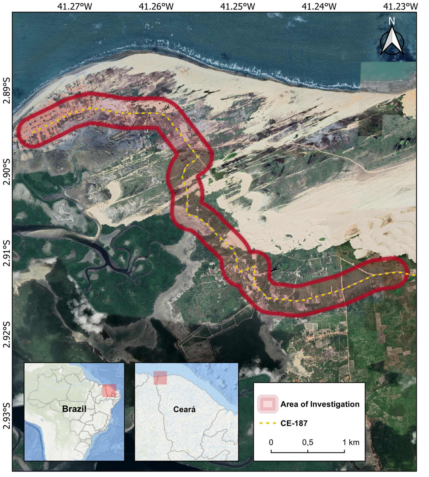
Resumo
Coastal zones are attractive for the development of economic interests (real estate and tourism) and are intensely occupied in a disorderly manner. Development in areas with available sediments can lead to conflicts between the natural movement of dunes and cities and communities and may result in burial processes. In addition, natural structures, such as dunes, play key roles in protecting against coastal erosion by balancing the beach-dune system with the sediment input, thus slowing the erosion process. This study aims to determine suitable areas for creating dune field dump sites in Barroquinha, Ceará, northeastern Brazil. The results showed that along the study area, the places with the greatest viability for creating dump sites were those furthest from the urban and permanent protection areas. In the stretch connecting Barroquinha City to the Bitupitá community on the CE-187 highway, 45 deposition points were monitored across five sectors under different environmental conditions. Sectors 2, 3, and 4 showed good responses to sediment fixation, in agreement with what was presented in the locational feasibility model. These results add to the discussion on urban infrastructure burying processes, making important contributions to urban planning and management in coastal areas. The results of this study will form an integral part of the Regional Contingency Plan for Incidents and/or situations of risk of environmental impacts in the coastal and/or oceanic zones of Ceará, which was conceived by the Chief Environment Scientist Program of Ceará State and contributes to the Action Plan against burying infrastructure by dune fields.
Referências
BAAS, A. C. W. Complex systems in aeolian geomorphology. Binghamton Special Issue of Geomorphology, 91:311-331, 2007. https://doi.org/10.1016/j.geomorph.2007.04.012
CANTELON, J. A.; GUIMOND, J.A.; ROBINSON, C.E.; MICHAEL, H.A.; KURYLYK, B.L . Vertical saltwater intrusion in coastal aquifers driven by episodic flooding: A review. Water Resources Research, p. 1–25, 2022. https://doi.org/10.1029/2022WR032614
CLAUDINO-SALES, V.; CARVALHO, A. M. Dinâmica Costeira Controlada por Promontórios no Estado do Ceará, Nordeste do Brasil. Geociências, v. 33, n. 4, p.579-595, 2014. Available: https://www.periodicos.rc.biblioteca.unesp.br/index.php/geociencias/article/view/9504. Accessed on: mar. 14, 2023.
GOOGLE. Google Earth Pro. Versão 2023. Disponível em: https://www.google.com/earth/. Accessed on: feb. 23, 2023.
GUO, J. J.; GONG, X.W.; FANG, L.D.; JIANG, D.M; ALA, M.; BUCCI, S.J.; SCHOLZ.; F.G.; GOLDSTEIN, G.; HAO, G.Y. Switching of dominant positions between two sand-fixing shrub species during the dune revegetation process is underlain by their contrasting xylem hydraulics and water-use strategies. Land Degradation and Development, v. 31, n. 10, p. 1195–1205, 2020. https://doi.org/10.1002/ldr.3493
IBGE. Manual do Usuário: Posicionamento Por Ponto Preciso. 2009 Available: http://www.ibge.gov.br/home/geociencias/geodesia/ppp/ manual_ ppp.pdf. 2009. Acessed on: July 03, 2024
JENNINGS, S., LOCKIE, S. Democratisation and capacity building in coastal zone decision-making in Australia the application of stakeholder analysis and social mapping. Gloucester Point, Virginia, USA: Virginia Institute of Marine Science; 2002, p.1-5. Available: http://cdc.fish.ku.ac.th/czap_website/abstracts/lockie.pdf. Acessed on: Jun. 21, 2023.
JUNIOR, W. C. G.; FERNANDES, D.; ALENCAR CASTRO, J. W. de. Analysis of physical and dynamic variables by Coastal Vulnerability Index (CVI) in Formosa Bay cove, Lagos Fluminense Region - Rio de Janeiro State. Revista Brasileira de Geomorfologia, v. 23, n. 4, p. 1812–1833, 2022. https://doi.org/10.20502/rbg.v23i4.2144
KAZUVA, E.; ZHANG, .J; TONG, Z.; LIU, X.P; MEMON, S.; MHACHE, E. GIS- and MCD-based suitability assessment for optimized location of solid waste landfills in Dar es Salaam, Tanzania. Environmental Science and Pollution Research, v. 28, n. 9, p. 11259–11278, 2021. https://doi.org/10.1007/s11356-020-11213-0
MARTÍNEZ, M. L.; GALLEGO-FERNÁNDEZ, J. B.; HESP, P. A. Restoration of Coastal Dunes. Springer Series on Environmental Management, p. 307–321, 2013. https://doi.org/10.1007/978-3-642-33445-0
MCKEE, E. D.A Study of Global Sand Seas. University Press of the Pacific.440p. 2004. https://doi.org/10.3133/pp1052
MORAES, A. C. R. Contribuições para a gestão da zona costeira do Brasil: Elementos para uma geografia do litoral brasileiro. São Paulo: Annablume, 2007.
NETO, A. R. X; MORAIS, J. O. DE; PINHEIRO, L. DE S. Modificações na geomorfologia marinha a partir de estruturas portuárias: o caso do Mucuripe, Fortaleza/CE. Geosciences, v. 37, n. 4, p. 793–805, 28 dez. 2018. https://doi.org/10.5016/geociencias.v37i4.12597
ROCHA, C. D. S.; VASCONCELOS, F. P.; AMARAL, D.N.; CASEMIRO, M.B.; BARRA, O.A.O. Vulnerabilidade socioambiental como base para a gestão costeira no município de Paracuru – Ceará. Revista Brasileira de Geografia Física, v. 13, n. 6, p. 2820, 2020. https://doi.org/10.26848/rbgf.v13.6.p2820-2839
ROCHA, M. N. PINHEIRO, L. S.; MORAIS, J.O. Avaliação dos parâmetros meteorológicos atuantes na migração dos campos de dunas móveis setentrionais da planície costeira de Paracuru, Ceará, Brasil. Revista Geociências, v. 39, n. 2000, p. 437–446, 2020. https://doi.org/10.5016/geociencias.v39i2.12676
RUZ, M.-H.; MEUR-FEREC, C. Influence of high water levels on aeolian sand transport: upper beach/dune evolution on a macrotidal coast, Wissant Bay, northern France. Geomorphology, v. 60, p. 73-87, 2004. https://doi.org/10.1016/j.geomorph.2003.07.011
OROPEZA-OROZCO, O.; SOMMER-CERVANTES, I., CARLOS-GÓMEZ, J., PRECIADO-LÓPEZ, J. C., ORTIZ-PÉREZ, M. A., & LOPEZ-PORTILLO, J. Assessment of vulnerability and integrated management of coastal dunes in veracruz, mexico. Coastal Management, v. 39, n. 5, p. 492–514, 2011. https://doi.org/10.1080/08920753.2011.598817
ÖZKAN, B, Ö.; E, SARIÇIÇEK, İ. GIS-based MCDM modeling for landfill site suitability analysis: a comprehensive review of the literature. Environmental Science Pollution Research. v. 26, n. 30, p. 30711-30730, 2019. https://doi.org/10.1007/s11356-019-06298-1
PYE, K. e TSOAR, H. Aeolian Sand and Sand Dunes. Springer Berlin Heidelberg, 396 p. 2009. https://doi.org/10.1007/978-3-540-85910-9
RYAN, S.; NIMICK, E. Multi-Criteria Decision Analysis and GIS. Story Maps Arcgis. 11, Agosto 2019. https://doi.org/10.1007/978-3-540-85910-9
SAATY, T. L. How to make a decision: The analytic hierarchy process. European Journal of Operational Research, v. 48, n. 1, p. 9–26, 1990. https://doi.org/10.1016/0377-2217(90)90057-I
SANTOS, R. F. Planejamento ambiental. São Paulo: Oficina de Texto, 2004. 184 p.
SHERMAN, D. J.; BAUER, B. O. Dynamics of beach-dune systems. Progress in Physical Geography, v. 17, p. 413-447, 1993. https://doi.org/10.1177/030913339301700402
SILVEIRA, I. R. L dos.; FERNANDES, D.; CABRAL, C. L.; OLIVEIRA, D. M. V de.; JUNIOR, W. C. G.; CASTRO, J.W de A. Dinâmica das Dunas Escalonares Transgressivas Sobre a Região do Peró - Cabo Frio, Rio de Janeiro. Revista Brasileira de Geomorfologia. v. 22, n. 4. 2021. https://doi.org/10.20502/rbg.v22i4.2041
TERCAN, E.; EYMEN, A.; URFALI, T; SARACOGLU, B. O. A sustainable framework for spatial planning of photovoltaic solar farms using GIS and multi-criteria assessment approach in Central Anatolia, Turkey. Land Use Policy, v. 102, n. October 2020, 2021. https://doi.org/10.1016/j.landusepol.2020.105272
VALENTE, R. O. A. Definição de áreas prioritárias para a conservação e preservação florestal por meio da abordagem multicritério em ambiente SIG. 2005. 121 f. Tese (Doutorado em Recursos Florestais) - Escola Superior de Agricultura "Luiz de Queiroz", Universidade de São Paulo, Piracicaba, 2005. Available: https://teses.usp.br/teses/disponiveis/11/11150/tde-15062005-154402/pt-br.php. Acessed on: may. 10, 2023.
VETTORAZZI, C. A. Avaliação multicritério, em ambiente SIG, na definição de área prioritárias a restauração florestal visando à conservação dos recursos hídricos, 2006. 151 f. Tese (Livre Docência em Topografia) - Escola Superior de “Luiz de Queiroz”, Universidade de São Paulo, Piracicaba. 2006. Available: https://teses.usp.br/teses/disponiveis/livredocencia/11/tde-06072007-103043/pt-br.php. Accessed on: may. 18, 2023.

Este trabalho está licenciado sob uma licença Creative Commons Attribution 4.0 International License.
Copyright (c) 2023 Matheus Domingos Andrade de Sá, Tiago Borges Ribeiro Gandra, Miguel da Guia Albuquerque, Davis Pereira de Paula, Marcelo de Oliveira Soares, Eduardo Lacerda Barros, Renan Gonçalves Pinheiro Guerra, Melvin Moura Leisner, Jade Moreira