
Palavras-chave
Bioma
Google Earth Engine
Incêndio
Monitoramento
Como Citar


Resumo
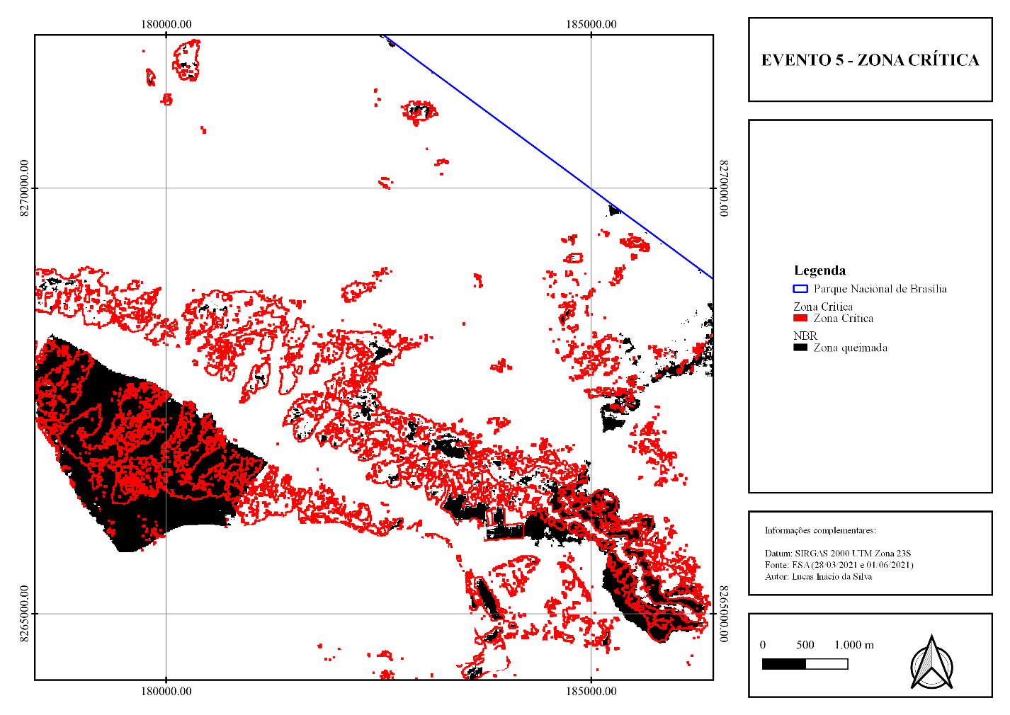
O Cerrado brasileiro é um dos maiores biomas do Brasil. Infelizmente a pressão antrópica está agravando os processos de degradação do bioma e juntamente com os processos de estiagem, os eventos de fogo surgem como grande fator de preocupação. Devem ser concebidos ferramentas de monitoramento, principalmente os que envolvem os conceitos de sensoriamento remoto, antepondo-se ao fenômeno de fogo, mitigando os efeitos devastadores. Sendo assim, a presente pesquisa tem como objetivo a determinação do limiar crítico à ocorrência de incêndios por meio do diagnóstico das condições de verdor, umidade e senescência da vegetação utilizando da análise temporal de imagens “Sentinel-2” no Parque Nacional de Brasília, para isso, faz-se necessário a determinação quantitativa de cada condição por meio da análise de eventos passados, determinando o limiar de criticidade que condicione a região apresentar condições que favoreçam o início de um incêndio bem como a construção de um algoritmo, no “Google Earth Engine”. Á área de estudo é o Parque Nacional de Brasília, com o acervo de dados de imagens “Harmonized Sentinel-2 MSI: MultiSpectral Instrument, Level-1C” dentro do “Google Earth Engine”. O algoritmo visa construir um sistema de máscaras para remover materiais das cenas, bem como o cálculo dos índices NDVI, NDII, PSRI e dNBR, extraindo os dados por meio da máscara de pixels queimados. Foi possível identificar seis períodos de ocorrência de fogo, a extração de dados permitiu a determinação estatística do limiar, sendo esse 0,580 para o NDVI, 0,015 para o NDII e 0.150 para o PSRI.
Referências
BAPTISTA, G. M. M., BENTO-GONÇALVES, A., VIEIRA, A. Avaliação das condições de verdor, umidade e de senescência da vegetação queimada no incêndio de braga, portugal, em outubro de 2017. In: II Encontro Luso-Afro-Americano de Geografia Física e Ambiente - Desafios para Afirmar a Lusofonia na Geografia Física e Ambiente, 2018, Guimarães, Portugal. Anais (on-line). Guimarães: CEGOT-UMinho, Centro de Estudos de Geografia e Ordenamento do Território da Universidade do Minho, 2018. Disponível em: http://repositorium.sdum.uminho.pt/bitstream/1822/60165/1/II_ELAAGFA_Baptista_et_al.pdf. Acesso em: 22 abr. 2020.
BARMPOUTIS, P.; PAPAIONNOU, P.; DIMIITROPOULOS, K.; GRAMMALIDIS, N. A review on early forest fire detection systems using optical remote sensing. Sensors, v. 20, 2020. https://doi.org/10.3390/s20226442
BENTO-GONÇALVES. Incêndios rurais – O triste fado português? Fundação Francisco Manoel dos Santos, 2022. Disponível em: https://www.ffms.pt/pt-pt/atualmentes/incendios-rurais-o-triste-fado-ortugues?fbclid=IwAR2hstJhcdvec8oAhMs2vG1bZp2J2DDmoFlMorSIKrCacWCywtlj7QqrvIY, acessado em 30 mar. 2023.
BENTO-GONÇALVES, A.; VIEIRA, A.; BAPTISTA, G. ROCHA, J.; MOURA, SARAH. The 2017 Large wildfire of braga - evaluation of the different conditions of the burned vegetation. Geo-Eco-Trop, v. 43, n. 4, p. 627-640, 2019.
CARELLA, E.; ORUSA, T.; VIANI, A.; MELONI, D.; BORGOGNO-MONDINO, E.; ORUSA, R. An integrated, tentative remote-sensing approach based on ndvi entropy to model canine distemper virus in wildlife and to prompt science-based management policies. MDPI: Animals, v. 12, n. 1049, 2022. https://doi.org/10.3390/ani12081049
COLLI, G. R.; VIEIRA, C. R.; DIANESE, J. C. Biodiversity and conservation of the cerrado: recento advances and old challanges. Biodiversity and Conservation, v. 29, p. 1465-1475, 2020. https://doi.org/10.1007/s10531-020-01967-x
DUAN, T.; CHAPMAN, S. C.; GUO, Y.; ZHENG, B. Dynamic monitoring of NDVI in wheat agronomy and breeding trials using an unmanned aerial vehicle. Field Crop Research, v. 210, p. 71-80, 2017. https://doi.org/10.1016/j.fcr.2017.05.025
EARTH RESOURCES OBSERVATION AND SCIENCE (EROS) (USA). Washington, United States of America. Washington: EarthExplorer, 2023. 12 imagens de satélite, color. Satélite Sentinel-2, instrumento MSI. Intervalo de tempo: de 05 mai 2016 a 02 mai. 2022. Lat. -15.6669, Long. -47.9997. Disponível em: https://earthexplorer.usgs.gov/. Acesso em: 05 nov. 2020
EUROPEAN SPACE AGENCE (ESA) (EUROPE). Europe: Copernicus Open Access Hub, s.d., 12 imagens de satélite, color. Satélite Sentinel-2, instrumento MSI. Intervalo de tempo: de 05 mai 2016 a 02 mai. 2022. Lat. -15.6669, Long. -47.9997. Disponível em: https://scihub.copernicus.eu/dhus/#/home. Acesso em: 05 nov. 2022
FASSNACHT, F. E.; SCHMIDT-RIESE, E.; KATTENBORN, T.; HERNÁNDEZ, J. Explaining sentinel 2-based dnbr and rdnbr variability with reference data from the bird’s eye (uas) perspective. International Journal of Applied Earth Observations and Geoinformation, n. 1, 2021. https://doi.org/10.1016/j.jag.2020.102262
FERNÁNDEZ-MANSO, A.; QUINTANO, C. A synergetic approach to burned area mapping using maximum entropy modeling trained with hyperspectral data and viirs hotspots. Remote Sensing, v. 12, n, 858, 2020. https://doi.org/10.3390/rs12050858
GEOPORTAL (Brasil). Brasília, Distrito Federal. Secretaria de Estado de Desenvolvimento Urbano e Habitação, Brasília: dados vetoriais de Cidades Administrativas, Vias Rodoviárias e Unidades de Conservação, 2022. Disponível em: https://www.geoportal.seduh.df.gov.br/geoportal/. Acesso em: 02 fev. 2022
GOOGLE (USA). Google Earth Engine, 2023. 12 imagens de satélite, color. Satélite Sentinel-2, instrumento MSI. Intervalo de tempo: de 05 mai 2016 a 02 mai. 2022. Lat. -15.6669, Long. -47.9997. Disponível em: https://code.earthengine.google.com/. Acesso em: 30 jan. 2023
GORELICK, N.; HANCHER, M.; DIXON, M.; ILYUSHCHENKO, S.; THAU, D.; MOORE, R. GEE: planetary-scale geospation analysis for everyone. Elsevier: Remote Sensing Enviroment, v.202, p. 18-27, 2017. https://doi.org/10.1016/j.rse.2017.06.031
HARDISKY, M.A., V. KLEMAS, and R.M. SMART. The Influences of Soil Salinity, Growth Form, and Leaf Moisture on the Spectral Reflectance of Spartina Alterniflora Canopies. Photogrammetric Engineering and Remote Sensing, v. 49, p. 77-83, 1983.
HOFMANN, G. S.; CARDOSO, M. C.; ALVES, R. J. V.; WEBER, E. J.; ALEXANDRE A. B.; TOLEDO, P. M.; PONTUAL, F. B.; SALLES, L. O.; HASENACK, H.; CORDEIRO, J. L. P.; AQUINO, F. E.; OLIVEIRA, L. F. B. The brazilian cerrado is becoming hotter and drier. Global Change Biology, v. 27, p. 4060-4073, 2021. https://doi.org/10.1111/gcb.15712
IBGE (Brasil). Brasília, Distrito Federal. Instituto Brasileiro de Geografia e Estatística, Brasília: dados vetoriais de biomas brasileiros. Disponível em: https://www.geoportal.seduh.df.gov.br/geoportal/. Acesso em: 02 fev. 2022
KAPLAN, G.; ADVAN, U. Object-based water body extraction model using Sentinel-2 satellite imagery. European Journal of Remote Sensing, v. 50, n.1, p. 137-143, 2017. https://doi.org/10.1080/22797254.2017.1297540
KEY, C. H.; BENSON, N. C. Landscape Assessment: Sampling and Analysis Methods. Landscape Assessment: Sampling and analysis Methods, 2006.
KEY, C. H.; BENSON, N. C. Meansuring and remote sensing of burn severity. Landscape Assessment: Sampling and analysis Methods, 1999.
MAGNO, R.; ROCHI, L.; DANIELLI, R.; MATESE, A.; GENNARO, S. F. D.; CHEN, C.; SON, N.; TOSCANO, P. Agroshadow: a new sentinel-2 cloud shadow detection tool for precision agriculture. Remote Sensing, v. 13, 2021. https://doi.org/10.3390/rs13061219
MAPBIOMAS (Brasil). MAPBIOMAS: Dados de Mapas das Coleções – Cobertura e Uso do Solo. Disponível em: https://mapbiomas.org/download. Acesso em: 02 fev. 2020.
MARCYIN. MarcYin/SIAC: for doi. Belgium: Bruxelles, 2019a.
MARCYIN. MarcYin/SIAC_GEE: To Publish the Code. Belgium: Bruxelles, 2019b.
McFEETERS, S.K. The use of the normalized difference water index (NDWI) in the delineation of open water features. International Journal of Remote Sensing, p. 1425-1432, 1996. https://doi.org/10.1080/01431169608948714
MERZLYAK, M. N.; GITELSON, A. A, CHIVKUNOVA, Olga B.; RAKITIN, Victor Yu. Non-destructive optical detection of pigment changes during leaf senescence and fruit ripening. Physiologia Plantarum, v. 106, p. 135-141, 1999. https://doi.org/10.1034/j.1399-3054.1999.106119.x
MILCZAREK, M.; ROBAK, A. Sentinel Water Mask (SWM) – new index for water detection on Sentinel-2 images. Conference: 7th Advanced Training Course on Land Remote Sensing, 2017.
MILLER, J. D.; THODE, A. E. Quantifying burn severity in a heterogeneous landscape with a relative version of the delta normalized burn ratio (dnbr). Remote Sensing, v. 109, p. 66-80, 2006. https://doi.org/10.1016/j.rse.2006.12.006
NURSAPUTRA, M.; LAREKENG, S. H.; NASRI; HAMZAH, A. S. The ndvi algorithm utilization on the GEE platform to monitor changes in forest density in mining areas. 2nd Biennal Conference of Tropical Biodiversity: IOP Conf. Series: Earth and Environmental Science, 2021. https://doi.org/10.1088/1755-1315/886/1/012100
RIBEIRO, N.; RUECKER, G.; GOVENDER, N.; MACANDZA, V.; PAIS, A.; MACHAVA, D.; CHAUQUE, A.; LISBOA, S. N.; BANDEIRA, R. The influence off fire frequency on the structure and botanical composition of savanna ecosystems. Ecology and Evolution, v. 9, p. 8253-8264, 2019. https://doi.org/10.1002/ece3.5400
ROUSE, J.W.; HAAS, R.H., SCHELL, J.A.; DEERING, D.W., 1974. Monitoring vegetation systems in the great plains with erts. In: Proceeding Of Erts‐1 Symposium. Anais ... NASA, United States.
ROY, D. P.; BOSCHETTI, L.; TRIGG, S. N. Remote sensing of fire severity: assessing the performance of the normalized burn ratio. Geoscience and Remote Sensing Letters, v. 3, n. 1, 2006. https://doi.org/10.1109/LGRS.2005.858485
SANTOS, S. M. B.; BENTO-GONÇALVES, A.; FRANCA-ROCHA, W.; BAPTISTA, G. Assessment of Burned Forest Area Severity and Postfire Regrowth in Chapada Diamantina National Park (Bahia, Brazil) Using dNBR and RdNBR Spectral Indices. Geosciences, v. 10, n. 106, 2020. https://doi.org/10.3390/geosciences10030106
SANTOS, S. M. B.; DUBERGER, S. G.; BENTO-GONÇALVES, A.; FRANCA-ROCHA, W.; VIEIRA, A.; TEIXEIRA, G. Remote Sensing Applications for Mapping Large Wildfires Based on Machine Learning and Time Series in Northwestern Portugal. Fire, v. 6, n. 43, 2023. https://doi.org/10.3390/fire6020043
SILVA. S. L.; BAPTISTA, G. M. M. Análise do grau de severidade de áreas queimadas na estação ecológica de águas emendadas por meio de dados do landsat 8. Revista Brasileira de Geografia Física, v. 8, n. 2, p. 431-438, 2015. https://doi.org/10.26848/rbgf.v8.2.p431-438
SRIWONGSITANON, N.; GAO, H.; SAVENIJE, H. H. G.; MAEKAN, E.; SAENGSAWANG, S.; THIANPOPIRUNG, S. Comparing the normalized difference infrared index (ndii) with root zone storage in a lumped conceptual model. Hydrology and Earth System Sciences, v. 20, p. 3361-3377, 2016. https://doi.org/10.5194/hess-20-3361-2016
SRIWONGSITANON, N.; GAO, H.; SAVENIJE, H. H. G.; MAEKAN, E.; SAENGSAWANG, S.; THIANPOPIRUNG, S. The Normalized Difference Infrared Index (NDII) as a proxy for soil moisture storage in hydrological modelling. Hydrology and Earth System Sciences, v. 19, 2015. https://doi.org/10.5194/hessd-12-8419-2015
VERNOOIJ, R.; GIONGO, M.; BORGES, M. A.; COSTA, M. M.; BARADAS, A. C. S.; WERF, G. R. V. D. Intraseasonal variability of greenhouse gas emission factors from biomass burning in the brazilian cerrado. Biogeosciences, v. 1, p. 1375-1393, 2021. https://doi.org/10.5194/bg-18-1375-2021

Este trabalho está licenciado sob uma licença Creative Commons Attribution 4.0 International License.
Copyright (c) 2022 Lucas Inácio Silva, Gustavo Macedo Mello Baptista