
Keywords
Vegetation index
Change in landscape
How to Cite


Abstract
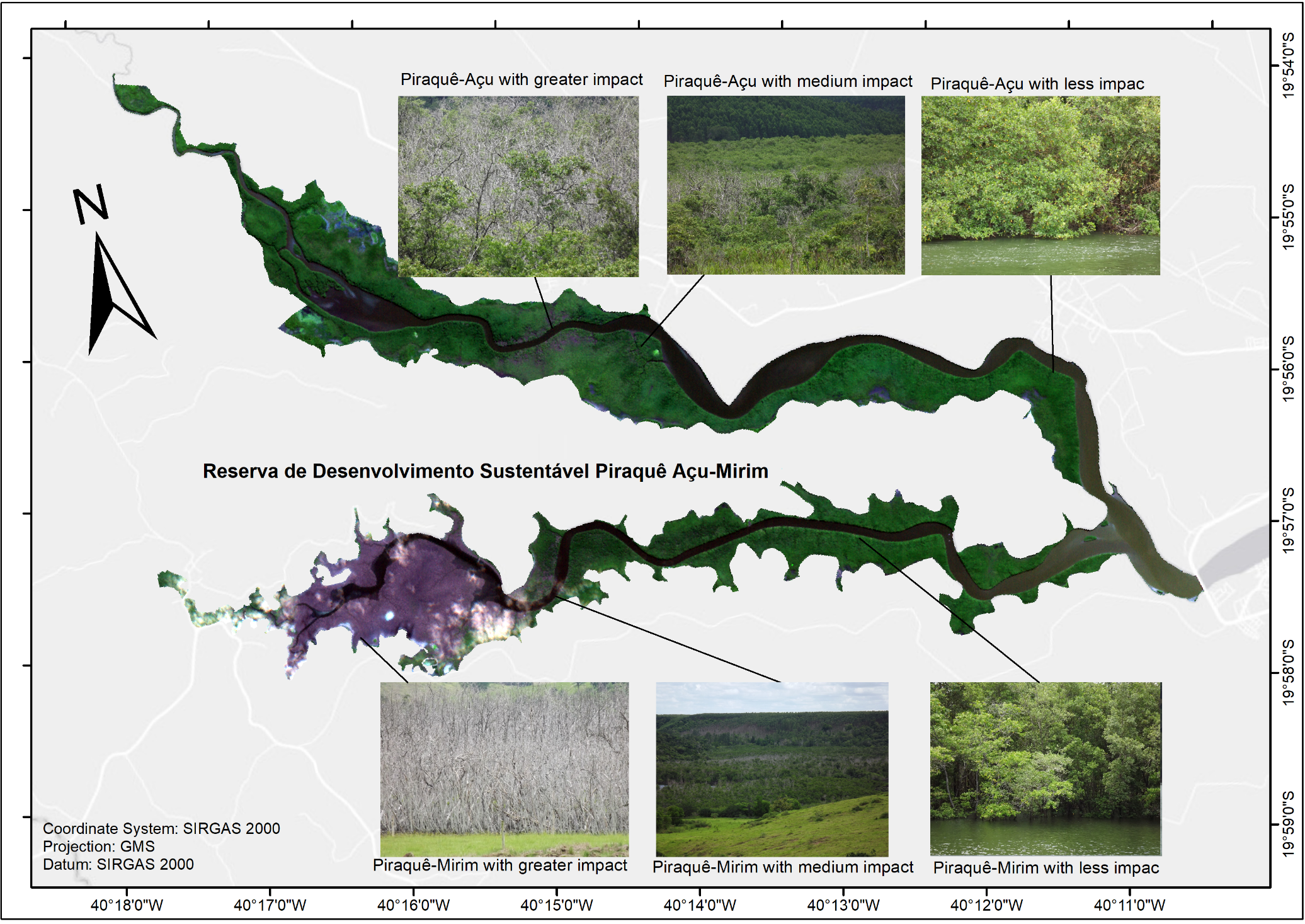
Among the various environments present on the planet that deserve due attention, as they have particularities and specificities of chemical, physical and biological orders, mangroves stand out. These ecosystems are mostly located in the intertropical zones where continental and oceanic waters meet, being crucial for a great diversity of animal species that find, in it, conditions that allow them to live and reproduce. In addition, this ecosystem is also for many local residents, such as traditional fishermen and crab farmers, a place for income generation, thus assuming an important socio-economic function. In addition, mangroves, through vegetation, help to protect the coast and act as important carbon sequestrants and stores. Among the less invasive methodologies that make it possible to analyze a series of dynamics of this environment, reducing costs with the field and the risks inherent to its natural characteristics, Remote Sensing stands out. Therefore, the general objective of this research was to evaluate the effectiveness of the NDVI, SAVI and LAI vegetation indices in recording the consequences of an extreme climatic event that occurred on June 1, 2016, in the mangroves of the Reserva de Desenvolvimento Sustentável Municipal Piraquê Açu-Mirim, located in Aracruz (ES), Southeast Coast Brazil. To achieve the objective, time series between February 2016 (before the event) and December 2020 were used. The results, which include maps and statistical graphs, allowed the delimitation of areas according to the intensities of the impacts and their consequences on the vegetation. While the vegetation of Piraquê-Açu underwent regeneration processes in all affected areas, in Piraquê-Mirim the area with the greatest impact remained destroyed. Given the socio-environmental importance of mangroves, it is necessary to implement projects aimed at their recovery. Both the methodology and the indices were efficient to achieve the objectives and can be reproduced in other mangroves.
References
ARACRUZ. Secretaria Municipal de Meio Ambiente- SEMAM. Reserva de Desenvolvimento Sustentável Municipal Piraquê-Açu e Piraquê-Mirim. Aracruz, 2020. Available: http://www.pma.es.gov.br/meio-ambiente/27. Access on 15 de abr. de 2021.
AGÊNCIA ESPACIAL EUROPÉIA – ESA. Copernicus. Available: https://scihub.copernicus.eu/dhus/#/home. Access on: 20 apr., 2021.
BERNARDINO, A.F.; Netto, S.A.; Pagliosa, P.R.; Barros, F., Christofoletti, R.A.; Rosa-Filho, J.S.; Colling, J.; Lana, P.C. Predicting ecological changes on benthic estuarine assemblages through decadal climate trends along Brazilian Marine Ecoregions. Estuar. Coast. Shelf Sci, v.166, p. 74–82, 2015. https://doi.org/10.1016/j.ecss.2015.05.021
BORATTO, I. M. P.; Gomide, R. L. Aplicação dos índices de vegetação NDVI, SAVI e IAF na caracterização da cobertura vegetativa da região Norte de Minas Gerais. In: Simpósio Brasileiro de Sensoriamento Remoto, XVI, 2013, Foz do Iguaçu. Anais. São José dos Campos: INPE, p. 7345-7352, 2013.
GEORGE, R.; Padalia, H.; Sinha, S. K. & Kumar, A. Senthil. Evaluation of the Use of Hyperspectral Vegetation Indices for Estimating Mangrove Leaf Area Index in Middle Andaman Island, India, Remote Sensing Letters, v. 9, n.11, p. 1099-1108, 2018. https://doi.org/10.1080/2150704X.2018.1508910
HUETE, A R. A soil-adjusted vegetation index (SAVI). Remote Sensing of Environment, v.25, p. 295-309, 1988. https://doi.org/10.1016/0034-4257(88)90106-X
IBGE - INSTITUTO BRASILEIRO DE GEOGRAFIA E ESTATÍSTICA, 2019a. Informações ambientais. Available: https://www.ibge.gov.br/geociencias/informacoes-ambientais/geologia/15822-geologia-1-250-000.html?=&t=download. Access on: 18 apr., 2021.
IBGE - INSTITUTO BRASILEIRO DE GEOGRAFIA E ESTATÍSTICA, 2019b. Malhas Territoriais. Available: https://www.ibge.gov.br/geociencias/organizacao-do-territorio/malhas-territoriais.html. Access on: 18 apr., 2021.
KAWAMUNA, A.; Suprayogi, A.; & Wijaya, A. P. Analysis of mangrove forest health based on NDVI classification method in Sentinel-2 image (Case Study: Teluk Pangpang, Banyuwangi Regency), Undip Geodesy Journal, v. 6, n. 1, pp. 277-284, 2017.
KGANYAGO, M.; Mhangara, P.; Alexandridis, T.; Laneve, G.; Ovakoglou, G.; Mashiyi, N. Validation of sentinel-2 leaf area index (LAI) product derived from SNAP toolbox and its comparison with global LAI products in an African semi-arid agricultural landscape. Remote Sens. Lett. 2020, v.11, p. 883–892. https://doi.org/10.1080/2150704X.2020.1767823
LANA, P.C.; Bernardino, A.F. Brazilian estuaries: a benthic perspective. In: Turra, A. (Ed.) Brazilian Marine Biodiversity Series, p.2520-1085, 2018. https://doi.org/10.1007/978-3-319-77779-5
MELO, C. A. A. Modelo para estimativa de biomassa de vegetação em áreas de manguezais por técnicas de sensoriamento remoto. 2016. Dissertação (Mestrado de Desenvolvimento e Meio Ambiente) - Universidade Federal de Pernambuco, Recife.
PEREIRA, L. E.; Amorim, G.; Grigio, A. M.; & Filho, A. C. P. Análise Comparativa entre Métodos de Índice de Água por Diferença Normalizada (NDWI) em Área Úmida Continental. Anuário do Instituto de Geociências. Rio de Janeiro, v. 41, p. 654-662, 2018. https://doi.org/10.11137/2018_2_654_662
ROUSE, J. W; Haas, R. H; Schell, J. A; & Deering, D. W. Monitoring vegetation systems in the Great Plains with ETRS. In: Third ETRS Symposium, NASA SP353, Washington, DC. 1: 309-317. 1973.
SANTOS, L. C. M.; Cunha-Lignon, M.; Schaeffer-Novelli, Y.; & Cintrón-Molero, G. Long-term effects of oil pollution in mangrove forests (Baixada Santista, Southeast Brazil) detected using a GIS-based multitemporal analysis of aerial photographs. Brazilian Journal of Oceanography, v. 60, n. 2, p. 159-170, 2012. https://doi.org/10.1590/S1679-87592012000200006
SCHAEFFER-NOVELLI, Y; Soriano-Sierra, E. J.; Vale, C. C.; Bernini, E.; Rovai, A. S.; Pinheiro, M. A. A.; Schmidt, A. J.; Almeida, R.; Coelho-Júnior, C.; Menghini, R. P.; Martinez, D.; Abuchahla, G. M. O.; Cunha-Lignon, M.; Charlier-Sarubo, S.; Shirazawa-Freitas, J.; Cintrón-Molero, G. Climate changes in mangrove forests and salt marshes. Brazilian Journal of Oceanography (Online), v. 64, p. 37-52, 2016. https://doi.org/10.1590/S1679-875920160919064sp2
SCHAEFFER-NOVELLI, Y. Mangue e Manguezal. In: Atlas dos Manguezais do Brasil (1ª ed.). Instituto Chico Mendes de Conservação da Biodiversidade. –ICMBio, Brasília, D.F, p. 17-22, 2018a.
SCHAEFFER-NOVELLI. A diversidade do ecossistema manguezal. In: Atlas dos Manguezais do Brasil (1ª ed.). Instituto Chico Mendes de Conservação da Biodiversidade. –ICMBio, Brasília, D.F, p. 23-36, 2018b.
SERVINO, R. N.; Gomes, L. E. O.; Bernardino, A. F. Extreme weather impacts on tropical mangrove forests in the Eastern Brazil Marine Ecoregion. Science of the Total Environment. New York, USA; n. 628, p.233-240, 2018. https://doi:10.1016/j. scitotenv. 2018.02.068
SILVA, J. B. Sensoriamento remoto aplicado ao estudo do ecossistema manguezal em Pernambuco/Janaína Barbosa da Silva. 2012. Dissertação (Doutorado em Ecossistema e Impactos Ambientais). Universidade Federal de Pernambuco, Recife.
SILVA, E. R. A. C.; Assis, D.R.S.; Silva. J.F.; Melo, J.G.S.; Galvíncio, J.D. Análise espaço-temporal das características do mangue urbano no estuário do Pina (Pernambuco). Revista Brasileira de Meio Ambiente, v. 1, n. 1, 2018.
SOAVINSKI, R.; MARETTI, C. Atlas dos Manguezais do Brasil / Instituto Chico Mendes de Conservação da Biodiversidade. – Brasília: Instituto Chico Mendes de Conservação da Biodiversidade, 2018. 176 p.: il.
TIAN, J.; Wang, L.; Li, X.; Gong, H.; Shi, Chen; Z., Ruofei; Liu, X. Comparison of UAV and WorldView-2 imagery for mapping leaf area index of mangrove forest. Int.J. Appl.Earth Obs.Geoinf. v. 61, p. 22–31, 2017. https://doi.org/10.1016/j.jag.2017.05.002
VALDERRAMA-LANDEROS, L.; Flores-de-Santiago, F.; Kovacs, J.M.; Flores-Verdugo, F. Uma avaliação de sensores remotos baseados em satélite comumente empregados para mapear espécies de mangue no México usando um esquema de classificação baseado em NDVI. Environ Monit Assess, v.190, n. 23, p. 1-13,2018. https://doi.org/10.1007/s10661-017-6399-z
WEISS, M.; Baret, F. S2ToolBox Level 2 Products: LAI, FAPAR, FCOVER. Avignon: Institut National de la Recherche Agronomique (INRA). 2016.

This work is licensed under a Creative Commons Attribution 4.0 International License.
Copyright (c) 2021 Marco Antonio Saraiva da Silva, André Luiz Lopes Faria