
Keywords
Mental Maps
Urban Resilience
Disaster Risk
How to Cite


Abstract
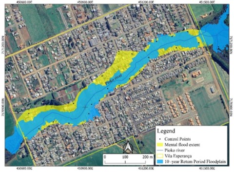
The occupation of wetlands has intensified the magnitude and frequency of flood damage in Brazilian watersheds. This study validates the accuracy of 2D hydrodynamic simulations against participatory flood hazard mapping in Vila Esperança (Guarapuava, Paraná State), adopting a 10-year return period (RP) as the critical threshold for residential feasibility. The methodology integrated HEC-RAS modeling based on high-resolution LiDAR data (micro-topographic precision) with a Mental Flood Mapping derived from residents' historical reports of the study area's residents. Results demonstrate that the 10-year RP simulation identifies a chronic risk that renders residential maintenance unsustainable, affecting 10.66% of the area (93 housing units and 260 people). In contrast, the Spoken Map, anchored in the extreme 2014 event, characterizes an acute risk, covering 15.67% of the village and affecting 144 housing units and 403 people. The findings reveal that while technical modeling provides geometric flow precision, collective memory offers the "ground truth" necessary for calibrating real hazards in ungauged basins. Consequently, areas within the 10-year flood footprint must be restricted from residential use. Furthermore, risk management must evolve beyond statistical probability to include integrated disaster reduction strategies, such as resettlement and early warning systems, to address the catastrophic scenarios identified by the community.
References
ALVES FILHO, A. P.; RIBEIRO, H. A percepção do caos urbano, as enchentes e as suas repercussões nas políticas públicas da Região Metropolitana de São Paulo. Saúde e Sociedade, v. 15, p. 145-161, 2006. https://doi.org/10.1590/S0104-12902006000300012
BEN, F. D.; PETSCH, C. Ensino de Geografia através da Cartografia Participativa: os desastres naturais na vivência dos alunos. Geografia (Londrina), v. 34, n. 2, p. 249-249, 2025. https://doi.org/10.5433/2447-1747.2025v34n2p249
BRASIL. Instituto Nacional de Meteorologia. BDMEP - Série Histórica de Precipitação Diária: Estação Colônia Vitória (Código 02551008). Dados diários de 1964 a 2020. Brasília, DF: INMET, 2025. Available: https://bdmep.inmet.gov.br/. Accessed on: aug. 20, 2025.
BRASIL. Ministério da Integração e do Desenvolvimento Regional. Atlas Digital de Desastres no Brasil. Brasília: SEDEC/MIDR, 2024. Available: https://atlasdigital.mdr.gov.br/. Accessed on: feb. 12, 2026.
CHOW, V. T. Open-channel hydraulics. New York: McGraw-Hill, 1959.
ELFES, A. Suábios no Paraná. Curitiba: Banco Lar Brasileiro S.A., 1971.
GOOGLE LLC. Google Earth. Version 10.0. [S. l.]. Google, 2025. Satellite image of Entre Rios District, Guarapuava, Paraná, Brazil. Available: google.com. Accessed on: jun. 15, 2025.
GUARAPUAVA ENFRENTA MAIOR ENCHENTE DOS ÚLTIMOS 37 ANOS. Diário de Guarapuava, Guarapuava, p. 1, 10 jun. 2014.
GUARAPUAVA. Município de Guarapuava. GeoGuarapuava. Guarapuava: Secretaria Municipal de Planejamento e Urbanismo, 2025. Available: https://portal.geoguarapuava.com.br/portal/apps/sites/#/geoguarapuava. Acessed on: nov. 25, 2025.
GUARAPUAVA. Município de Guarapuava. Municipal Drainage Plan of the Municipality of Guarapuava: summary report. Guarapuava: Secretaria Municipal de Planejamento e Urbanismo, 2022. Available: guarapuava.pr.gov.br. Accessed on: aug. 25, 2025.
HYDROLOGIC ENGINEERING CENTER (HEC). HEC-HMS Hydrologic Modeling System - User’s Manual. Version 4.9. Davis, CA: US Army Corps of Engineers, Institute for Water Resources, Hydrologic Engineering Center, 2021a.
HYDROLOGIC ENGINEERING CENTER (HEC). HEC-RAS River Analysis System - User’s Manual. Version 6.0. Davis, CA: US Army Corps of Engineers, Institute for Water Resources, Hydrologic Engineering Center, 2021b.
IBGE - INSTITUTO BRASILEIRO DE GEOGRAFIA E ESTATÍSTICA. Censo Demográfico de 2022. Rio de Janeiro: IBGE, 2022.
IBGE - INSTITUTO BRASILEIRO DE GEOGRAFIA E ESTATÍSTICA. Digital Meshes 2022: municipal mesh. Rio de Janeiro: IBGE, 2022. Available: https://www.ibge.gov.br/. Accessed on: jun. 15, 2025.
INSTITUTO NACIONAL DE METEOROLOGIA (INMET). Banco de Dados Meteorológicos para Ensino e Pesquisa (BDMEP). Brasília, DF: INMET, 2025. Available: https://portal.inmet.gov.br/. Accessed on: jun. 25, 2025.
JAAFAR, H. H.; AHMAD, F. A.; EL BEYROUTHY, N. GCN250, new global gridded curve numbers for hydrologic modeling and design. Scientific data, v. 6, n. 1, p. 145, 2019. https://doi.org/10.1038/s41597-019-0155-x
JENSON, S. K.; DOMINGUE, J. O. Extracting topographic structure from digital elevation data for geographic information system analysis. Photogrammetric engineering and remote sensing, v. 54, n. 11, p. 1593-1600, 1988.
KRAUSE, P., BOYLE, DP, e BÄSE, F.: Comparison of different efficiency criteria for hydrological model assessment, Advances in Geosciences, 5, 89–97, 2005. https://doi.org/10.5194/adgeo-5-89-2005
LI, R.; SPLINTER, K. D.; FELDER, S. LIDAR scanning as an advanced technology in physical hydraulic modelling: The stilling basin example. Remote Sensing, v. 13, n. 18, p. 3599, 2021. https://doi.org/10.3390/rs13183599
MONTE, B. E. O.; COSTA, D. D.; CHAVES, M. B.; MAGALHÃES, L. O.; UVO, C. B. Modelagem hidrológica e hidráulica aplicada ao mapeamento de áreas inundáveis. RBRH - Revista Brasileira de Recursos Hídricos, Porto Alegre, RS, v. 21, n. 1, p. 152-167, 2016. https://doi.org/10.21168/rbrh.v21n1.p152-167
OGILVIE, A.; BELAUD, G.; DELENNE, C.; BAILLY, J.-S.; BADER, J.-C.; OLEKSIAK, A.; FERRY, L.; MARTIN, D. Decadal monitoring of the Niger Inner Delta flood dynamics using MODIS optical data. Journal of Hydrology, v. 523, p. 368-383, 2015.
https://doi.org/10.1016/j.jhydrol.2015.01.036
OLIVEIRA, S. S.; PORTELLA, S.; YOSHIKAWA, C. T.; LOBOSCO, D.; DIAS, L. F.; OLIVEIRA, T. C. De Nosso Território Sabemos Nós: experiência de cartografia social para emergências e desastres. Ciência & Saúde Coletiva, v. 26, p. 4579-4590, 2021. https://doi.org/10.1590/1413-812320212610.11012021
PARANÁ. Polícia Militar. Corpo de Bombeiros. Estatísticas de ocorrências: registros históricos. Curitiba: CCB, [2024]. Available: http://www.bombeiroscascavel.com.br/registroccb/imprensa.php. Accessed on: feb. 14, 2026.
PERINI, Á. B.; MARCUZZO, F. F. N.; SILVA, D. R. A. Modelos Digitais de Elevação no mapeamento de suscetibilidade de inundação no município de Pedro Osório, RS. In: SIMPÓSIO BRASILEIRO DE SENSORIAMENTO REMOTO, 16., 2013, Foz do Iguaçu. Anais[...]. São José dos Campos: INPE, 2013. p. 6417-6424. Available: https://rigeo.sgb.gov.br/handle/doc/17444. Accessed on: jun. 1, 2026.
PORTO, R.M. Hidráulica básica. Projeto Reenge, 4. ed. São Marcos: EESC-USP. 2006.
QGIS Development Team. QGIS Geographic Information System. Versão 3.16. [S. l.]: Open Source Geospatial Foundation Project, 2020. Available: https://qgis.org. Acessed on: jun. 1, 2026.
RODRIGUES, L. L.; BLANCO, C. J. C. Vazão de pico em uma bacia hidrográfica com diferentes níveis de urbanização em Santarém/PA. Revista Ibero-americana de Ciências Ambientais, v. 9, n. 7, p. 62-75, 2018. https://doi.org/10.6008/CBPC2179-6858.2018.007.0007
SOARES FILHO, B. S. Análise de paisagem: fragmentação e mudanças. Belo Horizonte, 1998.
SOUSA, D. P. S.; GOERL, R. F. Proposta metodológica para estimar danos relacionados à inundação em áreas urbanas. In: COBRAC 2018. 2018. Available: https://ojs.sites.ufsc.br/index.php/cobrac/article/view/10865. Accessed on: jun. 1, 2026.
STEFENON, D. L.; DA SILVA, M. Colônia Vitória-Guarapuava/PR: identidade e território. Formação (Online), v. 2, n. 12, 2005.
TARBOTON, D. G. A new method for the determination of flow directions and upslope areas in grid digital elevation models. Water Resources Research, Washington, D.C., v. 33, n. 2, p. 309-319, 1997.
https://doi.org/10.1029/96WR03137
TUCCI, C. E. M. Hidrologia: ciência e aplicação. Porto Alegre: UFRGS, 1993. 943 p.
TUCCI, C. E. M. Modelos hidrológicos. Porto Alegre: Editora da UFRGS, 2005. 678p.

This work is licensed under a Creative Commons Attribution 4.0 International License.
Copyright (c) 2025 Bruno dos Santos Lemes, Leandro Redin Vestena