
Keywords
Water Resources
Geotechnologies
Multicriteria Analysis
Watersheds
How to Cite




Abstract
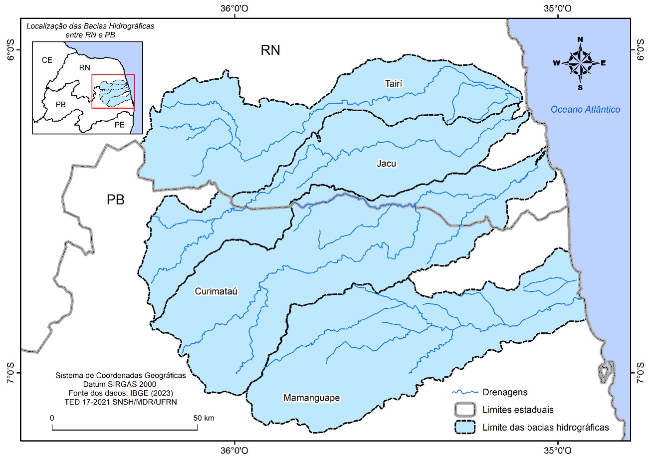
The degradation of springs compromises water security, particularly in strategic regions such as the transition zone between the Atlantic Forest and the Caatinga in northeastern Brazil. This study aims to present a methodology for prioritizing springs for restoration in four river basins located between the states of Rio Grande do Norte and Paraíba (Traíri, Jacu, Curimataú, and Mamanguape). To achieve this, a cartographic approach was adopted using geospatial data from multiple sources, geoprocessing techniques, including Digital Image Processing (DIP), and a Multicriteria Decision Analysis (MCDA). A Restoration Priority Index (RPI) was proposed, considering accessibility, environmental sensitivity, conservation status, and the land tenure and social context of the springs. Out of a total of 696 springs, 511 were selected due to the strong presence of agricultural land use and a low Water Security Index (WSI). The results indicate that most springs are under significant anthropogenic pressure, primarily driven by agricultural expansion and the reduction of native vegetation cover. A total of 135 springs (26.4%) were classified as high priority for restoration, being concentrated mainly in areas subject to intense human pressure. The proposed methodology proved to be an effective and replicable tool for supporting public policies and spring restoration programs aimed at strengthening water resilience and promoting sustainable territorial development.
References
AGÊNCIA NACIONAL DE ÁGUAS E SANEAMENTO BÁSICO (ANA). Sistema Nacional de Informações sobre Recursos Hídricos (SNIRH). Brasília, DF: ANA, 2025. Disponível em: https://www.snirh.gov.br/. Acesso em: 15 jan. 2025.
BOTELHO, R. G. M. Bacia hidrográfica e qualidade Ambiental. In: VITTE, A. C.; GUERRA, A. J. T. (org.). Reflexões sobre a geografia física no Brasil. 2. ed. Rio de Janeiro: Bertrand Brasil, 2007.
BRASIL. Ministério do Meio Ambiente. Índice de Prioridade de restauração florestal para segurança hídrica: uma aplicação para as regiões metropolitanas da Mata Atlântica. Ministério do Meio Ambiente – MMA. Brasília, DF: MMA, 2017.
BRASIL. Lei n. 9.433, de 8 de janeiro de 1997. Institui a Política Nacional de Recursos Hídricos, cria o Sistema Nacional de Gerenciamento de Recursos Hídricos, regulamenta o inciso XIX do art. 21 da Constituição Federal, e altera o art. 1º da Lei n. 8.001, de 13 de março de 1990, que modificou a Lei n. 7.990, de 28 de dezembro de 1989. Diário Oficial da União: seção 1, Brasília, DF, 9 jan. 1997. Disponível em: https://www.planalto.gov.br/ccivil_03/leis/l9433.htm. Acesso em: 04 jun. 2024.
BRASIL. Lei n. 12.651, de 25 de maio de 2012. Dispõe sobre a proteção da vegetação nativa; altera as leis nºs 6.938, de 31 de agosto de 1981, 9.393, de 19 de dezembro de 1996, e 11.428, de 22 de dezembro de 2006; revoga as leis nºs 4.771, de 15 de setembro de 1965, e 7.754, de 14 de abril de 1989, e a medida provisória nº 2.166-67, de 24 de agosto de 2001; e dá outras providências. Diário Oficial da União: Brasília, DF, 28 maio 2012. Disponível em: https://www.planalto.gov.br/ccivil_03/_ato2011-2014/2012/lei/l12651.htm. Acesso em: 04 jun. 2024.
BRASIL. Sistema Nacional de Cadastro Ambiental Rural (SICAR). Base pública de dados do Cadastro Ambiental Rural. Brasília, DF: Serviço Florestal Brasileiro, 2024. Disponível em: https://www.car.gov.br/publico/imoveis/index. Acesso em: 15 jun. 2024.
CENTRO NACIONAL DE MONITORAMENTO E ALERTAS DE DESASTRES NATURAIS (CEMADEN). Mapa Interativo do CEMADEN. São José dos Campos, SP: CEMADEN, 2024. Disponível em: https://mapainterativo.cemaden.gov.br/. Acesso em: 20 jun. 2024.
EMPRESA PARAIBANA DE PESQUISA, EXTENSÃO RURAL E REGULARIZAÇÃO FUNDIÁRIA (EMPAER). Portal Institucional. João Pessoa, PB: EMPAER, 2024. Disponível em: https://empaer.pb.gov.br/. Acesso em: 20 jan. 2024.
EMPRESA DE PESQUISA AGROPECUÁRIA DO RIO GRANDE DO NORTE (EMPARN). Monitoramento Meteorológico. Natal, RN: EMPARN, 2024. Disponível em: https://meteorologia.emparn.rn.gov.br/. Acesso em: 20 jun. 2024.
EUROPEAN SPACE AGENCY (ESA). Sentinel-2. Paris: ESA, 2025. Disponível em: https://www.esa.int/. Acesso em: 15 jan. 2025.
GOOGLE LLC. Google Earth Pro. Versão 7.3.7.1155 (64-bit). Moutain View, CA: Google LLC, 2026. Disponível em: https://earth.google.com/desktop/. Acesso em: 15 jan.2026
GORELICK, N; HANCHER, M; DIXON, M; ILYUSHCHENKO, S; THAU, D; MOORE, R. Google Earth Engine: planetary-scale geospatial analysis for everyone. Remote Sensing of Environment, v. 202, p. 18-27, 2017. https://doi.org/10.1016/j.rse.2017.06.031.HUT CHINSON, M. F.; DOWLING, T. I. A continental hydrological assessment of a new grid-based digital elevation model of Australia. Hydrological Processes, v. 5, n. 1, p. 45-58, 1991.
https://doi.org/10.1002/hyp.3360050105
INSTITUTO NACIONAL DE COLONIZAÇÃO E REFORMA AGRÁRIA (INCRA). Acervo Fundiário. Brasília, DF: INCRA, 2024. Disponível em: https://acervofundiario.incra.gov.br/acervo. Acesso em: 15 jan. 2025.
INSTITUTO BRASILEIRO DE GEOGRAFIA E ESTATÍSTICA (IBGE). Biomas e Sistema Costeiro-Marinho do Brasil: compatível com a escala 1:250.000. Rio de Janeiro: IBGE, 2019. Disponível em: https://www.ibge.gov.br/geociencias/informacoes-ambientais/vegetacao. Acesso em: 15 jan. 2024.
INSTITUTO BRASILEIRO DE GEOGRAFIA E ESTATÍSTICA (IBGE). Base cartográfica contínua do Brasil ao milionésimo, ao 1:250.000 e ao 1:100.000 (BC250): versão 2023. Rio de Janeiro: IBGE, 2023. Disponível em: https://www.ibge.gov.br/geociencias/cartas-e-mapas/bases-cartograficas-continuas.html. Acesso em: 15 jan. 2025.
INSTITUTO BRASILEIRO DE GEOGRAFIA E ESTATÍSTICA (IBGE). Sistema IBGE de Recuperação Automática – SIDRA. Censo Demográfico 2022: população residente. Rio de Janeiro: IBGE, 2024a. Disponível em: https://sidra.ibge.gov.br. Acesso em: 15 jun. 2024.
INSTITUTO BRASILEIRO DE GEOGRAFIA E ESTATÍSTICA (IBGE). Malha Municipal 2024. Rio de Janeiro: IBGE, 2024b. Disponível em: https://www.ibge.gov.br/geociencias/todos-os-produtos-geociencias/15774-malhas.html. Acesso em: 15 jan. 2025.
INSTITUTO NACIONAL DE METEOROLOGIA (INMET). Banco de Dados Meteorológicos para Ensino e Pesquisa (BDMEP). Brasília, DF: INMET, 2024. Disponível em: https://bdmep.inmet.gov.br/. Acesso em: 20 jun. 2025.
MALCZEWSKI, J. GIS and Multicriteria Decision Analysis. New York: John Wiley & Sons, 1999.
MALCZEWSKI, J. GIS-based multicriteria decision analysis: a survey of the literature. International Journal of Geographical Information Science, v. 20, n. 7, p. 703–726, 2006. https://doi.org/10.1080/13658810600661508
MARCUZZO, F; ANDRADE, L; MELO, D. Métodos de Interpolação Matemática no Mapeamento de Chuvas do Estado do Mato Grosso (Interpolation Methods in Mathematics of Rainfall Mapping of the State of Mato Grosso). Revista Brasileira de Geografia Física, [S. l.], v. 4, n. 4, p. 793–804, 2012. https://doi.org/10.26848/rbgf.v4i4.232714
ORGANIZAÇÃO DAS NAÇÕES UNIDAS (ONU). Transformando nosso mundo: a Agenda 2030 para o Desenvolvimento Sustentável. Nova York: ONU, 2015.
ORGANIZAÇÃO DAS NAÇÕES UNIDAS (ONU). United Nations Decade on Ecosystem Restoration (2021–2030). Resolução A/RES/73/284 da Assembleia Geral das Nações Unidas, de 1º de março de 2019. Nova York: ONU, 2019.
PEKEL, JF., COTTAM, A., GORELICK, N; BELWARD, A.S. High-resolution mapping of global surface water and its long-term changes. Nature 540, 418–422 (2016). https://doi.org/10.1038/nature20584
PLANET LABS PBC. Norway's International Climate and Forest Initiative (NICFI) Satellite Data Program. San Francisco: Planet. Disponível em: https://www.planet.com/nicfi/. Acesso em: 14 jan. 2025.
RIO GRANDE DO SUL. Casa Militar. Subchefia de Proteção e Defesa Civil. Boletim divulgado pela defesa Civil. Porto Alegre: Governo do Estado do Rio Grande do Sul, 2024.
SANTOS, D. C. A.; SOUSA, S. B.; Arantes, A. E.; AMORIM, R. F.; COSTA, C. W. Análise comparativa de qualidade de dados de estações pluviométricas automáticas e convencionais do INMET e dados do satélite GPM para o RN, Brasil (2017). Sociedade e Território, v. 34, p. 53-74, 2023.
SOUSA, S. B.; ARANTES, A. E.; CARDOSO, M. R. D.; FERREIRA, L. Análise comparativa entre dados TRMM e estações pluviométricas no Pantanal brasileiro: ano-base 2006. In: SIMPÓSIO BRASILEIRO DE SENSORIAMENTO REMOTO, 16, 2013, Foz do Iguaçu. Anais do XVI Simpósio Brasileiro de Sensoriamento Remoto. São José dos Campos: INPE, 2013. p. 6945-6952.
SOUZA JR., C. M.; SHIMBO, J. Z.; ROSA, M. R.; PARENTE, L. L.; ALENCAR, A. A.; RUDORFF, B. F. T.; HASENACK, H.; MATSUMOTO, M.; FERREIRA, L. G.; SOUZA-FILHO, P. W. M.; OLIVEIRA, S. W. de; ROCHA, W. F.; FONSECA, A. V.; MARQUES, C. B.; DINIZ, C. G.; COSTA, D.; MONTEIRO, D.; ROSA, E. R.; VÉLEZ-MARTIN, E.; WEBER, E. J.; LENTI, F. E. B.; PATERNOST, F. F.; PAREYN, F. G. C.; SIQUEIRA, J. V.; VIERA, J. L.; FERREIRA NETO, L. C.; SARAIVA, M. M.; SALES, M. H.; SALGADO, M. P. G.; VASCONCELOS, R.; GALANO, S.; MESQUITA, V. V.; AZEVEDO, T. Reconstructing three decades of land use and land cover changes in Brazilian biomes with Landsat archive and Earth Engine. Remote Sensing, v. 12, n. 17, art. 2735, 2020. https://doi.org/10.3390/rs12172735
TUNDISI, J. G.; MATSUMURA-TUNDISI, T. Recursos hídricos no século XXI. São Paulo: Oficina de Textos, 2011.
UNITED STATES GEOLOGICAL SURVEY (USGS). Shuttle Radar Topography Mission (SRTM) 1 Arc-Second Global. Reston, VA: USGS. Disponível em: https://earthexplorer.usgs.gov/. Acesso em: 22 jun. 2024.

This work is licensed under a Creative Commons Attribution 4.0 International License.
Copyright (c) 2025 Silvio Braz de Sousa, Daniel Carlos Alves Santos, Rodrigo de Freitas Amorim