
Keywords
Deforestation
Land-use and cover change
Mapbiomas
Land Change Modeler
How to Cite


Abstract
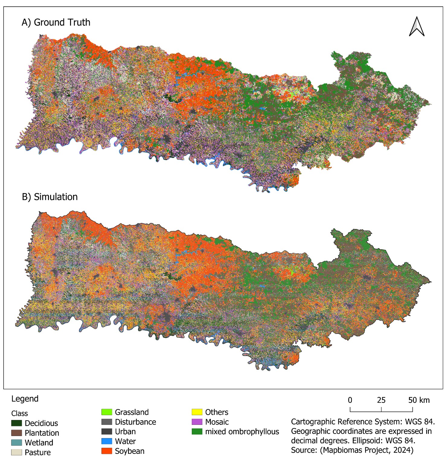
The Western Santa Catarina region underwent significant changes due to the 20th-century colonization, which led to landscape fragmentation and Atlantic Forest decline. The present study is an analysis of historical land-use change dynamics observed from 1985 to 2023, besides predicting future changes expected to happen up to 2050. It was done by using MapBiomas Collection 9 reclassified into 12 categories. Land use changes were modeled with TerrSet Land Change Modeler based on the Weighted Normalized Likelihood to model transition potentials; furthermore, the Markov chain approach was applied to model future scenarios. Model validation was performed through computing accuracy and agreement/disagreement statistics to compare a predicted map for 2023 data to a 2023 ground truth map, which proved highly accurate (0.936). Results recorded for the 2023–2050-time frame have shown that soybean areas are projected to increase by 38% and planted forests by 37.3%; therefore, they remain as key land use drivers. Native forest remnants will decline due to Mixed Ombrophilous Forest loss by 37.2% in addition to the 25% loss recorded from 1985 to 2023, and to increasing landscape fragmentation. The model accurately mapped the 2050 landscape and highlighted future regional challenges, according to which, soybeans and forest plantations will be the major change drivers in the region. This progress will have consequences for the remaining native forests. Result scopes are essential to help better understanding future impacts of land use change on ecosystems and communities and consequently, to lay the foundation for informed decision-making, as well as to guide conservation and landscape management.
References
BACHION, L. C.; ANTONIAZZI, L. Barcellos. Análise econômica da cadeia produtiva da recuperação da vegetação nativa. Oportunidades para a recuperação em escala de paisagem na Mata Atlântica. São Paulo, Brasil: AGRICONE, 2021. Available: https://www.agroicone.com.br/wp-content/uploads/2021/06/Analise-cadeia-restauracao_relatorio-final.pdf. Accessed on: apr. 14, 2026.
BENINI, R. de M.; ADEODATO, S. Economia da restauração florestal. São Paulo (SP): The Nature Conservancy, 136 pp. 2017
BOUSFIELD, C. G.; MORTON, O.; EDWARDS, D. P. Climate change will exacerbate land conflict between agriculture and timber production. Nature Climate Change, v. 14, n. 10, p. 1071–1077, 2024. https://doi.org/10.1038/s41558-024-02113-z
BRANCO, A. F. V. C.; LIMA, P. V. P. S.; MEDEIROS FILHO, E. S. de; COSTA, B. M. G.; PEREIRA, T. P. Avaliação da perda da biodiversidade na Mata Atlântica. Ciência Florestal, v. 31, p. 1885–1909, 2022. https://doi.org/10.5902/1980509853310
BRASIL. LEI No 12.651 de 25 de agosto de 2012. Dispõe sobre a proteção da vegetação nativa, Brasília, DF, 2012. Available: https://www.planalto.gov.br/ccivil_03/_ato2011-2014/2012/lei/l12651.htm. Accessed: 28 May 2025.
BRASIL. Plano Nacional de Recuperação da Vegetação Nativa 2025-2028: rota estratégica para recuperação de 12 milhões de hectareas. Brasilia: Ministério do Meio Ambiente e Mudança do Clima, 2024. Available: https://www.gov.br/mma/pt-br/composicao/sbio/dflo/plano-nacional-de-recuperacao-da-vegetacao-nativa-planaveg/planaveg_2025-2028_2dez2024.pdf. Accessed on: apr. 13, 2026.
CABALLERO, C. B.; BIGGS, T. W.; VERGOPOLAN, N.; WEST, T. A. P.; RUHOFF, A. Transformation of Brazil’s biomes: The dynamics and fate of agriculture and pasture expansion into native vegetation. Science of The Total Environment, v. 896, p. 166323, 2023. https://doi.org/10.1016/j.scitotenv.2023.166323
CABERNARD, L.; PFISTER, S.; HELLWEG, S. Biodiversity impacts of recent land-use change driven by increases in agri-food imports. Nature Sustainability, v. 7, n. 11, p. 1512–1524, 2024. https://doi.org/10.1038/s41893-024-01433-4
CATARINENSE, Observatório Agro. SC na frente. Observatório Agro Catarinense. 2025. Available: https://www.observatorioagro.sc.gov.br/publicacoes/artigos/diversos/sc-na-frente/. Accessed on: jun. 6, 2025.
CHEROL, C. C. de S.; FERREIRA, A. A.; LIGNANI, J.de B.; SALLES-COSTA, R. Regional and social inequalities in food insecurity in Brazil, 2013-2018. Cadernos de Saúde Pública, v. 38, p. e00083822, 2023. https://doi.org/https://doi.org/10.1590/0102-311XEN083822
EASTMAN, J. R. TerrSet LiberaGIS Geospatial Monitoring and Modeling System. Clark University, 2024. Available https://s45055.pcdn.co/centers/geospatial-analytics/www-content/blogs.dir/7/files/sites/354/2024/11/Terrset-liberaGIS-Manual.pdf. Accessed on: jan. 16, 2025
EASTMAN, J. R.; STEFANO, C. C.; HANNAH, R. R.; KAIXI, Z. A weighted normalized likelihood procedure for empirical land change modeling. Modeling Earth Systems and Environment, v. 5, p. 985–996, 2019. https://doi.org/10.1007/s40808-019-00584-0
EMBRAPA. SRTM - Portal Embrapa. 2005. Available: https://www.embrapa.br/satelites-de-monitoramento/missoes/srtm. Accessed on: feb. 26, 2025.
FAGAN, M. E.; KIM, D.-H.; SETTLE, W.; FERRY, L.; DREW, J.; CARLSON, H.; SLAUGHTER, J.; SCHAFERBIEN, J.; TYUKAVINA, A.; HARRIS, N. L.; GOLDMAN, E.; ORDWAY, E. M. The expansion of tree plantations across tropical biomes. Nature Sustainability, v. 5, no. 8, p. 681–688, 2022. https://doi.org/10.1038/s41893-022-00904-w
FAO. Global Forest Resources Assessment 2020. FAO, 2020. Available: https://openknowledge.fao.org/handle/20.500.14283/ca9825en. Accessed on: jun. 11, 2025.
GIRMA, R.; FÜRST, C.; MOGES, A. Land use land cover change modeling by integrating artificial neural network with cellular Automata-Markov chain model in Gidabo river basin, main Ethiopian rift. Environmental Challenges, v. 6, p. 100419, 2022. https://doi.org/10.1016/j.envc.2021.100419
HASSEN, E. E.; ASSEN, M. Land use/cover dynamics and its drivers in Gelda catchment, Lake Tana watershed, Ethiopia. Environmental Systems Research, v. 6, n. 1, p. 4, 2017.https://doi.org/10.1186/s40068-017-0081-x
HIJMANS, R. J. terra: Spatial Data Analysis. p. 1.7-83. 2020. https://doi.org/10.32614/CRAN.package.terra
IBGE. Divisões Regionais do Brasil.1990. Available: https://www.ibge.gov.br/geociencias/cartas-e-mapas/redes-geograficas/15778-divisoes-regionais-do-brasil.html?=&t=downloads. Accessed: feb. 26, 2025.
IBGE. Solos. 2006. Available: https://www.ibge.gov.br/geociencias/informacoes-ambientais/pedologia/15829-solos.html. Accessed: feb. 26, 2025.
IBGE. Downloads. 2023a. Available:https://www.ibge.gov.br/geociencias/downloads-geociencias.html?caminho=cartas_e_mapas/bases_cartograficas_continuas/bc100/acre/. Accessed on: feb. 26, 2025.
IBGE. Cidades e Estados: Santa Catarina. Panorama. 2023b. Available: https://cidades.ibge.gov.br/brasil/sc/panorama. Accessed on: jun. 6, 2025.
JALAYER, S.; SHARIFI, A.; ABBASI-MOGHADAM, D.; TARIQ, A.; QIN, S. Modeling and Predicting Land Use Land Cover Spatiotemporal Changes: A Case Study in Chalus Watershed, Iran. IEEE Journal of Selected Topics in Applied Earth Observations and Remote Sensing, v. 15, p. 5496–5513, 2022. https://doi.org/10.1109/JSTARS.2022.3189528
KLEIN, R. M. Mapa fitogeográfico do estado de Santa Catarina. IItajaí: Herbário Barbosa Rodrigues, 24p. 1978. (Flora Ilustrada Catarinense).
KUHN, M.; WING, J.; WESTON, S.; WILLIAMS, A.; KEEFER, C.; ENGELHARDT, A.; COOPER, T.; MAYER, Z.; KENKEL, B.; R CORE T.; BENESTY, M.; LESCARBEAU, R.; ZIEM, A.; SCRUCCA, L.; TANG, Y.; CANDAN, C.; HUNT, T. Caret: Classification and Regression Training. Version 7.0-1. 2024. Available: https://cran.r-project.org/web/packages/caret/index.html. Accessed on: may 16, 2025.
LETA, M. K.; DEMISSIE, T. A.; TRÄNCKNER, J. Modeling and Prediction of Land Use Land Cover Change Dynamics Based on Land Change Modeler (LCM) in Nashe Watershed, Upper Blue Nile Basin, Ethiopia. Sustainability, v. 13, n. 7, p. 3740, 2021. https://doi.org/10.3390/su13073740
LIMA, M.; SILVA JUNIOR, C. A. da; RAUSCH, L.; GIBBS, H. K.; JOHANN, J. A. Demystifying sustainable soy in Brazil. Land Use Policy, v. 82, p. 349–352, 2019. https://doi.org/10.1016/j.landusepol.2018.12.016
MAPBIOMAS PROJECT. Collection 9 of the Annual Land Cover and Land Use Maps of Brazil (1985-2023). MapBiomas Data, 2024. https://doi.org/10.58053/MapBiomas/XXUKA8
MATAVELI, G.; CHAVES, M.; GUERRERO, J.; ESCOBAR-SILVA, E. V.; CONCEIÇÃO, K.; de O., G. Mining Is a Growing Threat within Indigenous Lands of the Brazilian Amazon. Remote Sensing, v. 14, no. 16, p. 4092, no. 16, 2022. https://doi.org/10.3390/rs14164092
MAZZA, C. A. da S.; MAZZA, M. C. M.; ALMEIDA, D.; SANTOS, J. E.dos; FUSHITA, A. T. Land Use and Environmental Zoning of Mixed Ombrophilous Forests for Sustainable Use (Irati National Forest, Brazil Southern Region). Brazilian Archives of Biology and Technology, v. 59, p. e16160058, 2016. https://doi.org/https://doi.org/10.1590/1678-4324-2016160058
MONITORASC. Fitofisionomias: 3 classes (Klein 1978). 2021. Vector Data. Available: https://monitora.furb.br/layers/monitora_data:geonode:Klein_3classes. Accessed on: sep. 30, 2025.
MUTALE, B.; QIANG, F. Modeling future land use and land cover under different scenarios using patch-generating land use simulation model. A case study of Ndola district. Frontiers in Environmental Science, v. 12, 2024. https://doi.org/10.3389/fenvs.2024.1362666
PONTIUS, R. G. Quantification Error Versus Location Error in Comparison of Categorical Maps. Photogrammetric Engineering & RemoteSensing, v. 66, n. 8, p. 1011–1016, 2000.
PONTIUS, R. G. Statistical Methods to Partition Effects of Quantity and Location During Comparison of Categorical Maps at Multiple Resolutions. Photogrammetric Engineering & RemoteSensing, v. 68, n. 10, p. 1041–1049, 2002.
PONTIUS, R. G.; MILLONES, M. Death to Kappa: Birth of quantity disagreement and allocation disagreement for accuracy assessment. International Journal of Remote Sensing, v. 32, p. 4407–4429, 2011. https://doi.org/10.1080/01431161.2011.552923
PONTIUS, R. G.; SUEDMEYER, B. Components of Agreement between Categorical Maps at Multiple Resolutions. In: LUNETTA, Ross; LYON, John (eds.). Remote Sensing and GIS Accuracy Assessment. Boca Raton FL: CRC Press, 2004. p. 233–251. https://doi.org/10.1201/9780203497586.ch17
R CORE TEAM. R: A Language and Environment for Statistical Computing. Vienna, Austria: R Foundation for Statistical Computing, 2023. Available: https://www.R-project.org/. Accessed on: may 16, 2025
RIBEIRO, M. P.; MENEZES, G. P.; FIGUEIREDO, G. K. D. A.; de M., K.; VALENTE, R. A. Impacts of urban landscape pattern changes on land surface temperature in Southeast Brazil. Remote Sensing Applications: Society and Environment, v. 33, p. 101142, 2024. https://doi.org/10.1016/j.rsase.2024.101142
ROSA, M. R.; BRANCALION, P. H. S.; CROUZEILLES, R.; TAMBOSI, L. R.; PIFFER, P. R.; LENTI, F. E. B.; HIROTA, M.; SANTIAMI, E.; METZGER, J. P. Hidden destruction of older forests threatens Brazil’s Atlantic Forest and challenges restoration programs. Science Advances, v. 7, n. 4, p. eabc4547, 2021. https://doi.org/10.1126/sciadv.abc4547
SALAZAR, A.; BALDI, G.; HIROTA, M.; SYKTUS, J.; MCALPINE, C. Land use and land cover change impacts on the regional climate of non-Amazonian South America: A review. Global and Planetary Change, v. 128, p. 103–119, 2015. https://doi.org/10.1016/j.gloplacha.2015.02.009
SCARANO, F. Brazilian Atlantic forest: impact, vulnerability, and adaptation to climate change. Biodiversity and Conservation, v. 24, 2015. https://doi.org/10.1007/s10531-015-0972-y
SCHLINDWEIN, S. L.; FEITOSA DE VASCONCELOS, A. C.; BONATTI, M.; SIEBER, S.; STRAPASSON, A.; LANA, M. Agricultural land use dynamics in the Brazilian part of La Plata Basin: From driving forces to societal responses. Land Use Policy, v. 107, p. 105519, 2021. https://doi.org/10.1016/j.landusepol.2021.105519
SEEG. Sistema de Estimativas de Emissões e Remoções de Gases de Efeito Estufa. 2025. Available: https://plataforma.seeg.eco.br/. Accessed on: jun. 13, 2025.
SONG, X.-P.; HANSEN, M. C.; POTAPOV, P.; ADUSEI, B.; PICKERING, J.; ADAMI, M.; LIMA, A.; ZALLES, V.; STEHMAN, S. V.; DI BELLA, C. M.; CONDE, M. C.; COPATI, E. J.; FERNANDES, L. B.; HERNANDEZ-SERNA, A.; JANTZ, S. M.; PICKENS, A. H.; TURUBANOVA, S.; TYUKAVINA, Alexandra. Massive soybean expansion in South America since 2000 and implications for conservation. Nature Sustainability, v. 4, n. 9, p. 784–792, 2021. https://doi.org/10.1038/s41893-021-00729-z
SOUZA, J. M. de; MORGADO, P.; COSTA, E. M. da; VIANNA, L.F. de N. Modeling of Land Use and Land Cover (LULC) Change Based on Artificial Neural Networks for the Chapecó River Ecological Corridor, Santa Catarina/Brazil. Sustainability, v. 14, n. 7, p. 4038, n. 7, 2022. https://doi.org/10.3390/su14074038
SOUZA, R; RIBEIRO, J. The Impact of Brazil’s Agricultural Export Boom on Domestic Food Security. Law and Economy, v. 4, n. 1, p. 38–47, n. 1, 2025. https://doi.org/10.56397/LE.2025.01.05
TIAN, S.; WANG, S.; BAI, X.; LUO, G.; LI, Q.; YANG, Y.; HU, Z.; LI, C.; DENG, Y. Global patterns and changes of carbon emissions from land use during 1992–2015. Environmental Science and Ecotechnology, v. 7, p. 100108, 2021. https://doi.org/10.1016/j.ese.2021.100108
VANIN, G.T.; LACERDA, E. R.; MORI, G. M. Drivers of mangrove area change and suppression in Brazil from 2000 to 2020. Conservation Biology, v., p. e14426, 2024. https://doi.org/10.1111/cobi.14426
WINKLER, K.; FUCHS, R.; ROUNSEVELL, M.; HEROLD, M. Global land use changes are four times greater than previously estimated. Nature Communications, v. 12, n. 1, p. 2501, 2021. https://doi.org/10.1038/s41467-021-22702-2
ZHANG, Z.; LI, X.; LIU, X.; ZHAO, K. Dynamic simulation and projection of land use change using system dynamics model in the Chinese Tianshan mountainous region, central Asia. Ecological Modelling, v. 487, p. 110564, 2024. https://doi.org/10.1016/j.ecolmodel.2023.110564

This work is licensed under a Creative Commons Attribution 4.0 International License.
Copyright (c) 2025 Norman Blanco Lupio, Mirian Carbonera, Rodrigo Pinheiro Ribas