
Keywords
Landscape
Historical Cartography
Paquequer River
How to Cite


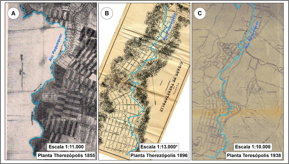
Abstract
When addressing landscape dynamics, the theoretical-conceptual intersection between cartography and geoecology converges in the interpretation and representation of spatial and environmental transformations, comprehensively elucidating the interactions between natural systems and human interventions in the territory. This study investigates the landscape transformations of the Paquequer River, located in the central area of Teresópolis (Rio de Janeiro, Brazil), using historical cartography as the main analytical tool and adopting geoecology as the theoretical framework, which serves as a geographic approach for analyzing landscape dynamics. In this regard, the central aim is to identify and understand the changes in the course of the Paquequer River and their correlations with the urban development of Teresópolis. The article addresses the evolution of the river and its influence on the urban development of Teresópolis from the 19th century to the present day. Gathering historical documents, such as maps, photographs, and municipal records, was essential for contextualizing the region's geographical and cultural changes. The historical maps were compared with contemporary cartographic data using georeferencing and vectorization techniques, allowing for an analysis of the modifications in the river’s course, particularly concerning its sinuosity index. The analysis revealed a decrease in the river’s sinuosity over time, suggesting a process of channel straightening. The study concludes that the Paquequer River in the genesis area of the municipality of Teresópolis is a crucial structuring element in the city's development and that integrating historical and geographical approaches is essential for effectively preserving and managing urban landscapes. The methodology employed provided a detailed understanding of landscape transformations, offering valuable insights for urban planning and environmental management.
References
ALMEIDA, D. A. de. Estrada de Ferro Teresópolis em Guapimirim-RJ: projeto de um percurso patrimonial. 2018. Dissertação (Mestrado) - Universidade Federal do Rio de Janeiro, Rio de Janeiro, 2018. Disponível em: http://objdig.ufrj.br/21/teses/875985.pdf. Acesso em: 20 jun. 2024
BERTRAND, G.; BERTRAND C. Uma Geografia transversal e de travessias: o meio ambiente através dos territórios e das temporalidades. Tradutor: Messias Modesto dos Passos. Maringá: Massoni, 2007.
CÂMARA MUNICIPAL DE TERESÓPOLIS. História de Teresópolis. Teresópolis, 2024. Disponível em: https://camarateresopolis.com.br/historia/. Acesso em: 01 jul. 2024.
CAVALCANTE, W. Planta de Teresópolis. 1938. Arquivo Nacional.
CHRISTOFOLETTI, A. 1981. Geomorfologia Fluvial. São Paulo: Edgard Blücher. 312p.
FERREZ, Gilberto. Colonização de Teresópolis à Sombra do Dedo de Deus-1700-1900. Rio de Janeiro: Instituto do Patrimônio Histórico, 1970.
FÉO, R. R. Raízes de Teresópolis Volume II: Novas Histórias 1500 – 2016. Editora Zem, Teresópolis, RJ, 2016.
GAMBINO, R.; PEANO, A. Nature Policies and Landscape Policies. Springer International Pu, 2016. https://doi.org/10.1007/978-3-319-05410-0
GOOGLE. Google Earth: imagem de satélite. 2020. Disponível em: https://earth.google.com/. Acesso em: 12 set. 2024.
GONÇALVES, F. C. C. A paisagem como fenômeno e objeto de interesse público: com que direito? Desenvolvimento e Meio Ambiente, v. 34, ago. 2015, p. 99-116. https://doi.org/10.5380/dma.v34i0.39224
INSTITUTO BRASILEIRO DE GEOGRAFIA E ESTATÍSTICA IBGE. Base Cartográfica Contínua do Estado do Rio de Janeiro, escala 1:25.000. Rio de Janeiro: IBGE, 2018. Disponível em: https://geoftp.ibge.gov.br/cartas_e_mapas/bases_cartograficas_continuas/bc25/rj/versao2018/. Acesso em: 06 set. 2024.
INSTITUTO BRASILEIRO DE GEOGRAFIA E ESTATÍSTICA IBGE. Panorama de Teresópolis. Rio de Janeiro: IBGE, 2024. Disponível em: https://cidades.ibge.gov.br/brasil/rj/teresopolis/panorama. Acesso em: 06 set. 2024.
INSTITUTO BRASILEIRO DE GEOGRAFIA E ESTATÍSTICA IBGE. Censo Demográfico 2022. Rio de Janeiro: IBGE, 2022. Disponível em: https://www.ibge.gov.br/estatisticas/sociais/populacao/22827-censo-2022.html?=&t=resultados. Acesso em: 06 set. 2024.
LEOPOLD, L. B.; WOLMAN, M. G. River channel patterns: braided, meandering, and straight. US Geological Survey Professional Paper 282-B, 1957. https://doi.org/10.3133/pp282B
LIMA, U. B. S.; SANTOS, K. S.; FERNANDES, M. C. Cartografia histórica e sig na análise das modificações da paisagem: cursos d'água na área gênese da cidade de Petrópolis/RJ. Revista Continentes, [S.l.], n. 17, dez. 2020. ISSN 2317-8825. Disponível em: https://revistacontinentes.com.br/index.php/continentes/article/view/310. Acesso em: 07 jul. 2024.
MENEZES, P. M. L.; LAETA, T.; SANTOS, K. S.; FERNANDES, M. C. Cartografia histórica e geoinformação. In: MENEZES, P. M. L.; FERNANDES, M. C.; CRUZ, C. B. M. (org.). Cartografias do ontem, hoje e amanhã. Curitiba: Appris, 2022. p. 51-92.
MIKLÓS, L.; KOCICKÁ, E.; IZAKOVICOVÁ, Z.; KOCICKÝ, D.; SPINEROVÁ, A.; DIVIAKOVÁ, A.; MIKLÓSOVÁ, V. Landscape as a Geosystem. Springer International Publishing, 2019. https://doi.org/10.1007/978-3-319-94024-3
PASSOS, M. M. O modelo GTP (Geossistema–Território–Paisagem) Como trabalhar. Revista Equador, v. 5, n. 1, p. 1-179, 2016. https://doi.org/10.26694/equador.v5i1.4274
PASSOS, M. M. O GTP aplicado ao estudo do meio ambiente. Métodos e técnicas no estudo da dinâmica da paisagem física nos países da CPLP- comunidade dos países de expressão portuguesa. Málaga, Espanha: EUMED .NET. biodiversity for sustainable development. Journal of Science Teacher Education, v. 6, p. 10-30, 2022.
REIS, G. A..; SILVA FILHO, G. H.; DA SILVA, P. T.; RIBEIRO, R. W. A paisagem no ordenamento urbano brasileiro: a produção de leis da paisagem no Recife e no Rio de Janeiro entre 1950 e 2019. Revista Espaço e Geografia, v. 24, n. 2, p. 197: 222-197: 222, 2021. https://doi.org/10.26512/2236-56562021e40280
REMINISCÊNCIAS DE TERESÓPOLIS. Reminiscências de Teresópolis. Facebook, 2024. Disponível em: https://www.facebook.com/groups/reminiscencias/?locale=pt_BR. Acesso em: 6 set. 2024.
RIBEIRO, R. W. Paisagem, Patrimônio e Democracia: novos desafios para políticas públicas. In: CASTRO, I. E.; RODRIGUES, J. N.; RIBEIRO, R. W. (orgs.). Espaços da Democracia: para a agenda da geografia política contemporânea. Rio de Janeiro: Bertrand Brasil, 2013.
RIBEIRO, R. W. Paisagem. In: IPHAN. (Org.). Dicionário IPHAN de Patrimônio Cultural. 1ed. Brasília: IPHAN, 2020, v. 1, p.1-35, 2020.
SANTOS, K. S. Toponímia e Cartografia Histórica de Teresópolis: paisagem, lugar e significados. Rio de Janeiro, 2017. Dissertação de mestrado em geografia, Programa de Pós-Graduação em Geografia da UFRJ, 2017. Disponível em: http://objdig.ufrj.br/16/teses/860533.pdf. Acesso em: 06 set. 2024.
SANTOS, K. S. Toponímia e geografia: novos caminhos para o estudo crítico da nomeação dos lugares. Rio de Janeiro, 2023. Tese de doutorado em Geografia, Programa de Pós-Graduação em Geografia da UFRJ, 2023. Disponível em: https://biblioteca.ppgg.igeo.ufrj.br/2023/11/nova-tese-do-ppgg-sobre-toponimia-e-geografia-a-nomeacao-dos-lugares/. Acesso em: 06 set. 2024.
SEMENOV, Y. M. Landscape planning: The applied branch in complex physical geography. Geography and Natural Resources, v. 38, p. 319-323, 2017. https://doi.org/10.1134/S1875372817040023
SILVEIRA, C. S.; DE SOUZA, K. V. Relações hidrológicas entre a pluviosidade e a vazão em uma série temporal (2007-2009) de uma bacia de drenagem de uso misto – Teresópolis, RJ, Brasil. Geociências, v. 31, n. 3, p. 395-410, 2012.
TREVISOL, A.; MACEIRA., J. Carta de suscetibilidade a movimentos gravitacionais de massa e inundação: município de Teresópolis-RJ. 2015.
VIEIRA, A. Therezopolis. Rio de Janeiro: Irmãos Pongetti Editores, 1938.
VIEIRA, V. T.; CUNHA, S. B. Mudanças na Morfologia dos Canais Urbanos: Alto Curso do Rio Paquequer, Teresópolis–RJ (1997/98– 2001). Revista Brasileira de Geomorfologia, v. 9, n. 1., 2008. https://doi.org/10.20502/rbg.v9i1.97.

This work is licensed under a Creative Commons Attribution 4.0 International License.
Copyright (c) 2024 Pietro Meirelles Brites, Manoel do Couto Fernandes