
Keywords
Multi-temporal analysis
Use of land
LST
LULC
How to Cite


Abstract
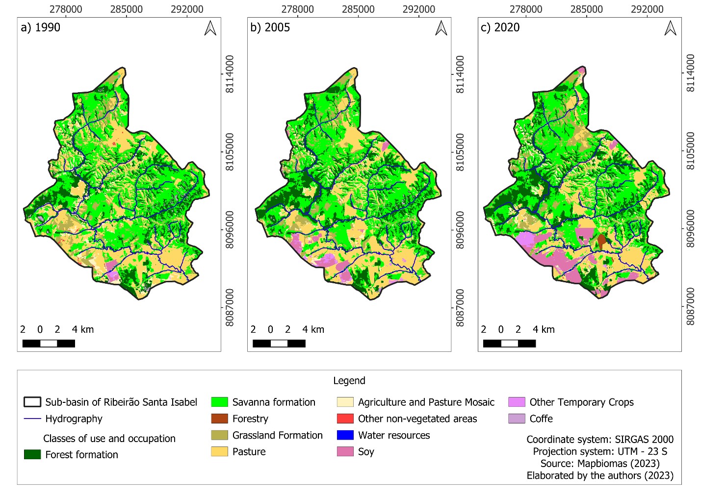
Faced with the recent crises of water capture and distribution, managing water resources is a practice that has been gaining prominence in discussions and debates about environmental issues. Thus, this article aims to analyze, in a spatio-temporal way, the Changes in Land Use and Occupation (LULC) and Surface Temperature (LST) in the water catchment sub-basin of Ribeirão Santa Isabel, located in the municipality of Paracatu, Minas Gerais (MG), between the years 1990 and 2020. The choice of the area is justified by the conflicts of use that encompass the sub-basin and by the fact that this is the only source of capture in the municipality, which has already carried out the alteration of the water resource responsible for the capture of water due to the intensity of agricultural practices in the region in the previous area. Through geoprocessing and Remote Sensing (RS) techniques, images from the Landsat-5 and Landsat-8 satellites were used to perform the LST calculations. Regarding usage and occupancy data, the images provided by the Mapbiomas platform were used. It was verified, through the increase in the percentage of the water class and vegetation and the decrease in the agricultural class, that the practices implemented in the study area, in order to conserve the remnants of the biome and maintain a good water availability to the municipality, are having an effect. It was also possible to conclude that LST is affected by LULC, and that the greatest variations occur in non-vegetated areas.
References
ALMEIDA, M. I. S.; DA SILVA, L. A. P.; LEITE, M. E.; LAURENTINO, C. M. DE M.; MARQUES, S. C. S.; LEITE, M. R. Ilhas de calor urbano em Montes Claros–MG. Revista do Departamento de Geografia. v. 40, p. 120-131, 2020. https://doi.org/10.11606/rdg.v40i0.163718.
ÁLVARES, C. A.; STAPE, J. L.; SENTELHAS, P. C.; GONÇALVES, J. L. M.; SPAROVE, G. Köppen’s climate classification map for Brazil. Meteorologische Zeitschrift. v. 22, p. 711-728, 2013. https://doi.org/10.1127/0941-2948/2013/0507.
ARCGIS – ARC GEOGRAPHIC INFORMATION SYSTEM. ArcGis: Software, 2022.Available: http://www.esri.com/software/arcgis/index.html. Acessed on: 10 Jan. 2023.
BELMOK, A.; RODRIGUES-OLIVEIRA, T.; LOPES, F.; MIRANDA, H.; KRÜGER, R.; KYAW, C. LongTerm Effects of Periodical Fires on Archaeal Communities from Brazilian Cerrado Soils. Archea. v. 2019, p. 1-12, 2019. https://doi.org/10.1155/2019/6957210
CARRASCO, R. A.; PINHEIRO, M. M. F.; MARCATO JR, J.; CICERELLI, R. E.; SILVA, P, A.; OSCO, L, P.; RAMOS, A. P. M. Land use/land cover change dynamics and their effects on land surface temperature in the western region of the state of São Paulo, Brazil. Regional Environmental Change. v. 20, p. 1-12, 2020. https://doi.org/10.1007/s10113-020-01664-z.
COSTA, M. M. L.; CAVALCANTE, A. S.; VILARINHO, C. M. R.; MULLER, M. G.; MONTE-MOR, R. C. A.; GONÇALVES, J. A. C. A Geração de Conflitos pelo Uso da Água na Bacia do Rio Paracatu, Noroeste de Minas Gerais, Brasil. Revista Brasileira de Geografia Física. v. 14, p. 834-846, 2021. https://doi.org/10.26848/rbgf.v14.2.p834-846.
CUNHA, J. E. F.; BRAVO, J. V. M. Effects of environmental protection policies on fragile areas of a watershed occupied by agriculture in the Brazilian Cerrado. Journal of Environmental Management. v. 319, p. 1-12, 2022. https://doi.org/10.1016/j.jenvman.2022.115695.
EMRAN, A.; ROY, S.; BAGMAR, S. H.; MITRA, C. Assessing topographic controls on vegetation characteristics in Chittagong Hill Tracts (CHT) from remotely sensed data. Remote Sensing Applications: Society and Environment, v. 11, p. 198-208, 2018. https://doi.org/10.1016/j.rsase.2018.07.005.
FATHIZAD, H.; TAZEH, M.; KALANTARI, S.; SHOJAEI, S. The investigation of spatiotemporal variations of land surface temperature based on land use changes using NDVI in southwest of Iran. Journal of African Earth Sciences. v. 134, p. 249-256, 2017. http://dx.doi.org/10.1016/j.jafrearsci.2017.06.007.
GHAUSI, S. A.; TIAN, Y.; ZERE, E.; KLEIDON, A. Radiative controls by clouds and thermodynamics shape surface temperatures and turbulent fluxes over land. Proceedings of the National Academy of Sciences, v. 120, n. 29, p. e2220400120, 2023. https://doi.org/10.1073/pnas.2220400120.
GOVIND, N.; RAMESH, H. The impact of spatiotemporal patterns of land use land cover and land surface temperature on an urban cool island: a case study of Bengaluru. Environmental Monitoring and Assessment, v. 191, p. 1-20, 2019. https://doi.org/10.1007/s10661-019-7440-1
GUHA, S.; GOVIL, H. Seasonal variability of LST-NDVI correlation on different land use/land cover using Landsat satellite sensor: a case study of Raipur City, India. Environment Development and Sustainability, v. 24, p. 8823-8839, 2022. https://doi.org/10.1007/s10668-021-01811-4
GUILHERME, A. P.; BIUDES, M. S.; MOTA, D. dos S.; DE MUSIS, C. R. Relationship between soil cover type and surface temperature. Sociedade & Natureza, Uberlândia, v. 32, p. 539–550, 2020. https://doi.org/10.14393/SN-v32-2020-47462.
GUILHERME, A. P.; MOTA, A. B. DOS S.; MOTA, D. DOS S.; MACHADO, N. G.; BIUDES, M. S. Uso de índice de vegetação para caracterizar a mudança no uso do solo em Coari - AM. Sociedade & Natureza, Uberlândia, v. 28, p. 301-310, 2016. http://dx.doi.org/10.1590/1982-451320160209.
HUNKE, P.; MUELLER, E. N.; SCHRÖDER, B.; ZEILHOFER, P. The Brazilian Cerrado: assessment of water and soil degradation in catchments under intensive agricultural use. Ecohydrology. v. 8, p. 1154-1180, 2015. https://doi.org/10.1002/eco.1573
IEF – INSTITUTO ESTADUAL DE FLORESTAS. Parque Estadual de Paracatu, 2011. Available: http://www.ief.mg.gov.br/parque-estadual/1412. Acessed on: 10 Jan. 2023.
LEMES, M. DA C. R.; REBOITA, M. S.; TORRES, R. R. Mudança no uso e cobertura da terra na bacia do Rio Tietê e seus impactos na Temperatura da Superíficie (TS). Revista Brasileira de Climatologia. v. 27, p. 2237-8642, 2020. http://dx.doi.org/10.5380/abclima.v27i0.68836.
MACHADO, R. B.; RAMOS NETO, M. B.; PEREIRA, P.; CALDAS, E. F.; GONÇALVES, D. A.; SANTOS, N. S.; TABOR, K.; STEININGER, M. Estimativas de Perda da Área do Cerrado Brasileiro. Brasília: Conservation International do Brasil; 2004.
MALAV, L. C.; YADAV, B.; TAILOR, B. L.; PATTANAYAK, S.; SINGH, S. V.; KUMAR, N.; REDDY, G. P. O.; MINA, B. L.; DWIVEDI, B. S.; JHA, P. K. Mapping of Land Degradation Vulnerability in the Semi-Arid Watershed of Rajasthan, India. Sustainability. v. 14, p. 1-16, 2022. https://doi.org/10.3390/su141610198.
MAPBIOMAS. Mapas e dados, 2022. Available: http://Mapbiomas.org. Acessed on: 10 Jan. 2023.
MARTINS, A. P.; GALVANI, E. Relação entre uso e cobertura da terra e parâmetros biofísicos no Cerrado Brasileiro. Revista do Departamento de Geografia, v. 40, p. 148-162, 2020. https://doi.org/10.11606/rdg.v40i0.167739.
MIRANDA, M. R. S.; NEVES, L. F. S.; KREITLOW, J. P.; NEVES, S. M. A. S.; NEVES, R. J. Distribuição de queimadas e mudanças na cobertura vegetal e uso da terra no bioma Pantanal, Cáceres-Brasil. Caminhos de Geografia. v. 19, p. 91–108, 2018. https://doi.org/10.14393/RCG196508
MOISA, M. B.; DEJENE, I. N.; MERGA, B. B.; GEMEDA, D. O. Impacts of land use/land cover dynamics on land surface temperature using geospatial techniques in Anger River Sub-basin, Western Ethiopia. Environmental Earth Sciences, v. 81, p. 1-14, 2022. https://doi.org/10.1007/s12665-022-10221-2
NOURELDEEN, N.; MAO, K.; YUAN, Z.; SHEN, X.; XU, T.; QIN, Z. Analysis of the Spatiotemporal Change in Land Surface Temperature for a Long-Term Sequence in Africa (2003–2017). Remote Sensing. v. 12, p. 1-24, 2020. https://doi.org/10.3390/rs12030488.
PACHECO, F.A.L.; FERNANDES, L.F.S.; VALLE, R.F.; VALERA, C.A.; PISSARRA, T.C.T. Land degradation: Multiple environmental consequences and routes to neutrality. Current Opinion Environmental Science & Health. v. 5, p. 79–86, 2018. https://doi.org/10.1016/j.coesh.2018.07.002.
PAL, S.; ZIAUL, S. Detection of land use and land cover change and land surface temperature in English Bazar urban centre. The Egyptian Journal of Remote Sensing and Space Science. v. 20, p. 125–145, 2017. http://dx.doi.org/10.1016/j.ejrs.2016.11.003.
PRUSKI, F. F.; RODRIGUEZ, R. DEL G.; DE NOVAES, L. F.; DA SILVA, D. D.; RAMOS, M. M.; TEIXEIRA, A. DE F. Impacto das vazões demandadas pela irrigação e pelos abastecimentos animal e humano, na bacia do Paracatu. Revista Brasileira de Engenharia Agrícola e Ambiental. v. 11, p. 199-210, 2007. https://doi.org/10.1590/S1415-43662007000200011.
QGIS – Q GEOGRAPHIC INFORMATION SYSTEM. Open-Source Geospatial Foundation Project, 2019. Available: http://www.qgis.org/it/site/. Acessed on: 10 Jan. 2023.
QGIS – Q GEOGRAPHIC INFORMATION SYSTEM. Open-Source Geospatial Foundation Project, 2021. Available: http://www.qgis.org. Acessed on: 10 Jan. 2023
ROMSHOO, S.A.; AMIN, M.; SASTRY, K.L.N.; PARMAR, M. Integration of social, economic, and environmental factors in GIS for land degradation vulnerability assessment in the Pir Panjal Himalaya, Kashmir, India. Applied Geography. v. 125, p. 1-15, 2020. https://doi.org/10.1016/j.apgeog.2020.102307.
ROY, S.; PANDIT, S.; EVA, E. A.; BAGMAR, S. H.; PAPIA, M.; BANIK, L.; DUBE, T.; RAHMANF.; RAZI, M. A. Examining the nexus between land surface temperature and urban growth in Chattogram Metropolitan Area of Bangladesh using long term Landsat series data. Urban Climate, v. 32, p. 100593, 2020. https://doi.org/10.1016/j.uclim.2020.100593.
SARIF, MD. O.; GUPTA, R. D. Evaluation of seasonal ecological vulnerability using LULC and thermal state dynamics using Landsat and MODIS data: a case study of Prayagraj City, India (1987–2018). Environmental Science and Pollution Research. p. 1-34, 2022. https://doi.org/10.1007/s11356-022-21225-7.
SANTOS, A. P. DOS; SANTIL, F. L. DE P.; CARBONE, S.; SILVA, C. R. DA. The influence of urban and mineral expansion on surface temperature variation. Acta Scientiarum. Technology, v. 45, n. 1, p. e60114. 2022. https://doi.org/10.4025/actascitechnol.v45i1.60117
SEMEA – Secretaria de Meio Ambiente de Paracatu. Acervo técnico de mapeamento municipal. 2023.
SOUZA, C. M.; SHIMBO, J. Z.; ROSA, M. R.; PARENTE, L. L.; ALENCAR, A. A.; RUDORFF, B. F. T.; HASENACK, H.; MATSUMOTO, M.; FERREIRA, L. G.; SOUZA-FILHO, P. W. M.; DE OLIVEIRA, S. W.; ROCHA, W. F.; FONSECA, A. V.; MARQUES, C. B.; DINIZ, C. G.; COSTA, D.; MONTEIRO, D.; ROSA, E. R.; VÉLEZ-MARTIN, E.; WEBER, E. J.; LENTI, F. E. B.; PATERNOST, F. F.; PAREYN, F. G. C.; SIQUEIRA, J. V.; VIERA, J. L.; FERREIRA NETO, L. C.; SARAIVA, M. M.; SALES, M. H.; SALGADO, M. P. G.; VASCONCELOS, R.; GALANO, S.; MESQUITA, V. V.; AZEVEDO, T. Reconstructing three decades of lande use and landa cover changes in Brazilian Biomes with Landsat archive and Earth engine. Remote Sensing. v. 12, p. 1-24, 2020. https://doi.org/10.3390/rs12172735.
UFV – UNIVERSIDADE FEDERAL DE VIÇOSA. Mapa de Solos do Estado de Minas Gerais, 2022. Available: https://dps.ufv.br/softwares/. Acessed on: 10 Jan. 2023.
ULLAH, W.; AHMAD, K.; ULLAH, S.; TAHIR, A. A.; JAVED, M. F.; NAZIR, A.; ABBASI, A. M.; AZIZ, M.; MOHAMED, A. Analysis of the relationship among land surface temperature (LST), land use land cover (LULC), and normalized difference vegetation index (NDVI) with topographic elements in the lower Himalayan region. Heliyon, v. 9, n. 2, p. e13322, 2023. https://doi.org/10.1016/j.heliyon.2023.e13322.
USGS - UNITED STATE GEOLOGICAL SURVEY. Landsat surface reflectance level-2 science products, 2018. Available: https://www.usgs.gov/land-resources/nli/landsat. Acessed on: 10 Jan. 2023.
USGS – UNITED STATES GEOLOGICAL SURVEY. Earth Explorer, 2023. Available: https://earthexplorer.usgs.gov/. Acessed on: 10 Jan. 2023.
VARGAS, T.; BELLADONA, R.; SGORLA, V.; SBABO, L. C. Vulnerabilidade intrínseca da água subterrânea como alicerce na gestão do uso do solo em bacias de captação. Revista Brasileira de Geografia Física. v. 15, p. 710-720, 2021. https://doi.org/10.26848/rbgf.v15.2.p710-720
WANG, Y. C.; HU, B. K. H.; MYINT, S. W.; FENG, C. C.; CHOW, W. T. L.; PASSY, P. F. Patterns of land change and their potential impacts on land surface temperature change in Yangon, Myanmar. Science of the Total Environment. v. 643, p. 738–750, 2018. https://doi.org/10.1016/j.scitotenv.2018.06.209.
WANG, P.; YU, P.; LU, J.; ZHANG, Y. The mediation effect of land surface temperature in the relationship between land use-cover change and energy consumption under seasonal variations. Journal of Cleaner Production. v. 340, p. 1-15, 2022. https://doi.org/10.1016/j.jclepro.2022.130804.
ZAP – ZONEAMENTO AMBIENTAL PRODUTIVO. Zoneamento Ambiental Produtivo da sub-bacia do Ribeirão Santa Isabel, 2018. Available: http://www.meioambiente.mg.gov.br/component/content/article/13-informativo/3168-zoneamento-ambiental-e-produtivo-. Acessed on: 10 jan. 2023.

This work is licensed under a Creative Commons Attribution 4.0 International License.
Copyright (c) 2022 Arthur Pereira dos Santos, Henzo Henrique Simionatto, Letícia Tondato Arantes, Vanessa Cezar Simonetti, Renan Angrizani de Oliveira, Jomil Costa Abreu Sales, Darllan Collins da Cunha e Silva