
Keywords
Geostatistics
Quantification
Relief rugosity
How to Cite


Abstract
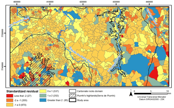
The quantification of abiotic features is a process in Geodiversity focused studies to indicate priority areas for conservation. Although some quantification methods are in use, doubts remain as to their applicability, particularly the relationship between coefficients of geodiversity and rugosity. In this perspective, this study proposes to analyze this relationship through the geostatistical models of Local Moran’s I and Geographically Weighted Regression (GWR), applied in sub-basins of one of the most important karstic regions in Brazil. To simulate the rugosity coefficient, the Global Relief Dissection Index was used, which consists of a combination of morphometric indices that enable the estimation of a given region’s power of dissection. The application of Local Moran’s I showed geodiversity and relief dissection potential behavior patterns, demonstrating that the variables have spatial dependence and are correlated at certain points. The application of GWR was successful, although the model was not able to explain the regional relationship between the coefficients of geodiversity and relief dissection. Nevertheless, it enabled local analysis of different behaviors through the spatialization of local R2 and residuals. It can be inferred that there are other variables that interfere in the local geodiversity, especially, for being a geosystem with characteristics specific.
References
ALMEIDA F. F. M. O cráton do São Francisco. Revista Brasileira de Geociências,v. 7: p. 285-295, 1977. https://doi.org/10.25249/0375-7536.1977349364
ANSELIN, L. Local indicators of spatial association - LISA. Geographical Analysis v.27, 1995. Available: http://www.dpi.inpe.br/gilberto/livro/analise/cap5-areas.pdf. Accessed on: Jul. 10, 2018.
BENITO-CALVO, AFONSO et al. Assessing regional geodiversity: the Iberian Peninsula. Earth Surface Processes and Landforms, Burgos, Espanha, n. 34, p. 1433-1445, abr. 2009. https://doi.org/10.1002/esp.1840
BRILHA, J. Inventory and Quantitative Assessment of Geosite and Geodiversity Sites: a Review. Geoheritage, n. 2, v. 8, p. 119-134, 2016. https://doi.org/10.1007/s12371-014-0139-3
GILBERT, J.; DANIELPOL, D. L.; Stanford, J. A. Groundwater Ecology, v. 1. Academic Press Limited, San Diego, California, p.571, 1994.
GRAY, M. Geodiversity: valuing and conserving abiotic nature. Chichester: Ed. Wiley Blackwell, 2004.
HACK, J. T. Stream-profile analysis and stream-gradient index. Journal of Research of the United States Geological Survey, v. 1, n. 4, p. 421-429, 1973.
HJORT, J.; LUOTO, M. Geodiversity of high-latitude landscapes in northern Finland. Elsevier. Geomorphology, Oslo, Finlandia, n. 115, p. 109-116, feb. 2010. https://doi.org/10.1016/j.geomorph.2009.09.039
HORTON, R.E. Erosional development of streams and their drainage basins: hydrophysical approach to quantitative morphology. Bulletin of the Geological Society of America Bull, n.56, p. 275-370, mar. 1945. https://doi.org/10.1130/0016-7606(1945)56[275:EDOSAT]2.0.CO;2
KOT, R. A comparison of results from geomorphological diversity evaluation methods in the Polish Lowland (Toruń Basin and Chełmno Lakeland). Geografisk Tidsskrift-Danish. Journal of Geography, v. 118, n. 1, p. 17-35, 2018. https://doi.org/10.1080/00167223.2017.1343673
LOBO, C.; FONSECA; FERREIRA D.; GARCIA, R. A. Verticalização e permeabilização do solo urbano nos setores censitários de Belo Horizonte/MG. Revista Brasileira de Estudos Urbanos e Regionais. Recife, v.17, p. 215-228, dez. 2015. http://dx.doi.org/10.22296/2317-1529.2015v17n3p215
LOVELOCK, J. E. Gaia as seen through the atmosphere. Atmospheric Environment. 1972. https://doi.org/10.1016/0004-6981(72)90076-5
MADALOSSO, A.; VERONESEV, V. Considerações sobre a estratigrafia das rochas carbonatadas do Grupo Bambuí na região de Arcos, Pains e Lagoa da Prata, MG. Congresso Brasileiro de Geologia, Recife, v. 2, n. 30, p. 635-648, jan. 1978.
MAGALHÃES, P. M. Análise estrutural qualitativa das rochas do Grupo Bambuí na porção sudoeste da Bacia do São Francisco. Ouro Preto, p. 1-100 (Tese de Mestrado – Departamento de Geologia da Escola de Minas / Universidade Federal de Ouro Preto, 1989.
MARTINS, T. Mapeamento geomorfológico da folha piumhi, Minas Gerais. 2013. 157 p. Dissertação (Programa de Pós-Graduação em Geografia) - Instituto de Geografia, Universidade Federal de Uberlândia, Uberlândia, 2013. https://doi.org/10.14393/ufu.di.2013.200
MELELLI, L.; VERGARI, F.; LIUCCI, L.; DEL MONTE, M. Geomorphodiversity index: Quantifying the diversity of landforms and physical landscape, Science of The Total Environment. 2017. https://doi.org/10.1016/j.scitotenv.2017.01.101
MENEGASSE L. N., GONÇALVES J. M., FANTINEL L. M. 2002. Disponibilidades Hídricas na Província Cárstica de Arcos-Pains-Doresópolis, Alto São Francisco, Minas Gerais, Brasil. Revista Águas Subterrâneas, 16: 1-19, 2002. https://doi.org/10.14295/ras.v16i1.1297
PELLITERO, R. O. Geomorfología, paleoambiente cuaternario y geodiversidad en el Macizo de Fuentes Carrionas-Montaña Palentina. Tese de Doutorado, Departamento de Geografia, Universidade de Valladolid, p. 1085, 2012. https://doi.org/10.35376/10324/2495
PEREIRA, E. O.; RUCHKYS, U.; PELLITERO, R. Modelagem da Geodiversidade na Área de Proteção Ambiental Sul da Região Metropolitana de Belo Horizonte MG. Geonomos, v. 21, p. 97-101, 2013. https://doi.org/10.18285/geonomos.v21i2.277
PEREIRA E. O.; RUCHKYS, U. A. Quantificação e análise da geodiversidade aplicada ao geoturismo na área de proteção ambiental sul da região metropolitana de Belo Horizonte, Minas Gerais. Ra’e Ga, Curitiba, v.37, p.207 - 226, 2016. http://dx.doi.org/10.5380/raega.v37i0.41642
RUBAN, D. A. Geodiversity as a precious national resource: A note on the role of geoparks. Resources Policy, Elsevier, v. 53, pages 103-108, 2017. https://doi.org/10.1016/j.resourpol.2017.06.007
RUBAN, D. A.; Yashalova, N. N. Geodiversity meanings in global geoparks: an empirical study. Environmental Earth Sciences, v. 77, n. 22, p. 1-8, 2018. https://doi.org/10.1007/s12665-018-7962-9
RUCHKYS, U. A.; CASTRO, P. T. A.; SANTOS, D. J.; BITTENCOURT, J. S. R. Patrimônio em Geossistemas Ferruginosos: Potencial de Uso para o Geoturismo. Revista Latino-Americana de Estudos em Cultura e Sociedade Revista Latinoamericana de Estudios en Cultura y Sociedad | Latin American Journal of Studies in Culture and Society, Rio Grande do Sul v. 4, n. 2, 2018. https://doi.org/10.23899/relacult.v4i2.902
SAMPAIO, T. V. M. Parâmetros morfométricos para melhoria da acurácia do mapeamento da rede de drenagem: uma proposta baseada na análise da Bacia Hidrográfica do Rio Benevente –ES. Tese de Doutorado. IGC/UFMG. Belo Horizonte, 2008.
SENA, I. C. Modelagem do potencial geoturístico do Parque Estadual do Sumidouro. 2015. 115 f. Dissertação (Mestrado em Análise e Modelagem de Sistemas Ambientais) - Departamento de Cartografia do Instituto de Geociências, Universidade Federal de Minas Gerais, Belo Horizonte, 2015.
SENA, I.; AZEVEDO, U.; TRAVASSOS, L. E. Geotourism Potential in Karst Geosystems: An example from the Lund Warming Ramsar Site, Minas Gerais, Brazil. Catena, 2022. https://doi.org/10.1016/j.catena.2021.105717
SERRANO, E. C.; RUIZ FLAÑO, P. Geodiversidad: Concepto, Evaluación y Aplicación Territorial. El Caso De Tiermes (Caracena). Boletín de la A.G.E. n. 45, p. 79-98, 2007.
SERVIÇO GEOLÓGICO DO BRASIL – CPRM. Geologia da folha Piumhi. Brasília, 2008.
SILVA, A. B. Hidrogeologia de Meios Cársticos. Universidade Federal de Minas Gerais, Belo Horizonte,1998.
SILVA, M.L.N., DO NASCIMENTO, M.A.L.; MANSUR, K.L. Quantitative Assessments of Geodiversity in the Area of the Seridó Geopark Project, Northeast Brazil: Grid and Centroid Analysis. Geoheritage, 2019. Available: https://link.springer.com/article/10.1007/s12371-019-00368-z. Acessed on: Jun. 10, 2020.
SOCIEDADE EXCURSIONISTA ESPELEOLÓGICA - SEE. Projeto Arcos Pains Espeleologia - PROAPE. Área Cárstica de Pains. MPF/Ibama/FEAM/UFOP/FEOP/SEE. DEGEO/EM/UFOP. Ouro Preto, p 549, ago. 2012.
SOUZA, F. E.; FONSECA, B.; COELHO, F. Compartimentação do relevo baseada em parâmetros morfométricos: uma proposta de índice global de dissecação do relevo. I Congresso Nacional de Geografia Física, Campinas, v.1, p. 1-12, jul. 2017. https://doi.org/10.20396/sbgfa.v1i2017.2085
TEIXEIRA P. C. D.; DIAS M. S. Levantamento espeleológicos da região cárstica de Arcos, Pains, Doresópolis, Córrego Fundo e Iguatama. Congresso Brasileiro de Espeleologia, 27, Januária MG. Anais: 193-199, 2003.
TRAVASSOS, L. E. P. Princípios de Carstologia e Geomorfologia Cárstica. ICMBio, Brasília, 2019.
USGS – UNITED STATES GEOLOGICAL SURVEY. Shuttle Radar Topography Mission. Earth Explorer, 2018. Available: https://earthexplorer.usgs.gov/. Accessed on: Jul. 10, 2018.
ZWOLIŃSKI Z. B.; GUDOWICZ J. Geomorphometric analysis of morphoclimatic zones on the Earth. In: Jasiewicz J, 2015. Available: https://geomorphometry.org/wp. Accessed on: Nov. 15, 2022.

This work is licensed under a Creative Commons Attribution 4.0 International License.
Copyright (c) 2022 Fabiano Vieira de Souza, Úrsula de Azevedo Ruchkysa, Bráulio Magalhães Fonseca, Carlos Lobo