
Keywords
Sediments
Landscape transformation
How to Cite


Abstract
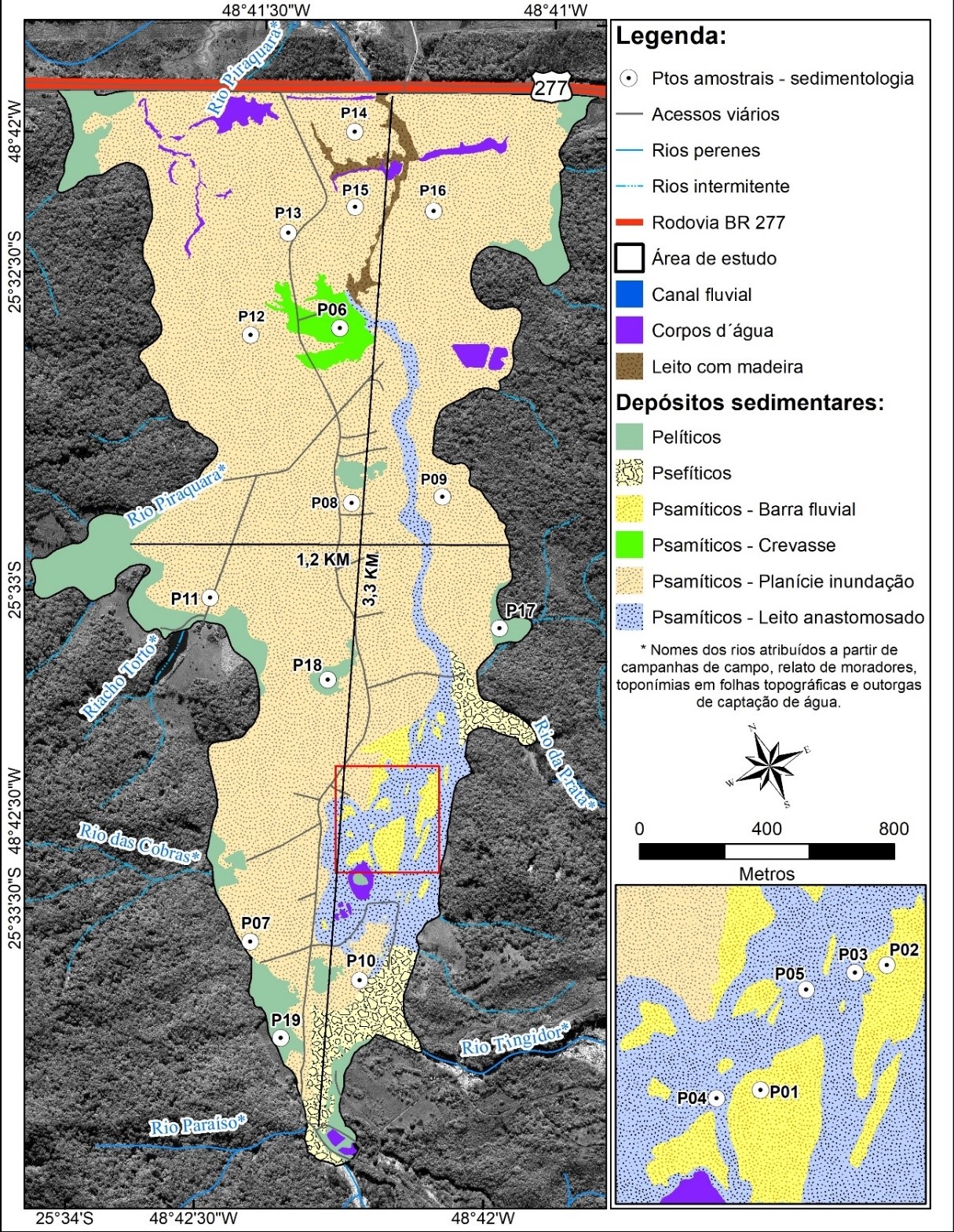
Extreme mud and debris flows can bury alluvial plains. In current literature, there exists a significant knowledge gap regarding this process, since information about the sedimentological characteristics and estimates of the volumes of these deposits, are still scarce. Such knowledge is important for understanding the role of these events in the morphogenesis of the alluvial plains of the highland mountain margins. The study area located in the Jacareí River basin (coast of the State of Paraná, Brazil) was recently buried by mud slides in March 2011, therefore, our objective is to analyze the sedimentology and estimate the volume of instantaneous deposits formed by the aforementioned gravitational processes. The deposits were mapped based on a geospatial database. Afterwards, samples were collected for laboratory analysis. To estimate the volume, field samples were collected, measuring the thickness of the deposits, which were then interpolated in a GIS environment. Pelitic (9%), psephytic (4%) and psammitic (87%) deposits were identified. The psammitic deposits showed two distinct behaviors as a function of the flow and burial dynamics of the alluvial plain. The total volume of the deposit was estimated at 1,7 million tons of sediment. The results demonstrate the magnitude of the 2011 event, since in a period of less than 24 hours the Jacareí river basin moved more than 8.5 times the annual production of sediments from the hydrographic units that drain into the Estuarine Complex of Paranaguá.
References
ANGULO, R. J. Mapa do Cenozóico do litoral do Estado do Paraná. Boletim Paranaense de geociências, v. 55, n. 1, p. 25–42, 2004. http://dx.doi.org/10.5380/geo.v55i0.4281
AVILA-DIAZ, A.; BENEZOLI, V.; JUSTINO, F.; TORRES, R.; WILSON, A. Assessing current and future trends of climate extremes across Brazil based on reanalyses and earth system model projections. Climate Dynamics, v. 55, n. 5, p. 1403–1426, 2020. https://doi.org/10.1007/s00382-020-05333-z.
ÁVILA, A.; JUSTINO, F.; WILSON, A.; BROMWICH, D.; AMORIM, M. Recent precipitation trends, flash floods and landslides in southern Brazil. Environmental Research Letters, v. 11, n. 11, p. 114029, 2016. http://dx.doi.org/10.1088/1748-9326/11/11/114029.
BOLDRINI, E. B.; PAULA, E. V. Gestão Ambiental Portuária: Subsídio para o licenciamento das Dragagens. 1. ed. Antonina: ADEMADAN, 2009.
BORGA, M.; STOFFEL, M.; MARCHI, L.; MARRA, F.; JAKOB, M. Hydrogeomorphic response to extreme rainfall in headwater systems: Flash floods and debris flows. Journal of Hydrology, v. 518, p. 194–205, 2014. https://doi.org/10.1016/j.jhydrol.2014.05.022
BRADY, N. C.; WEIL, R. R. Arquitetura e propriedades físicas do solo. In: BRADY, N. C.; WEIL, R. R. (Eds.). Elementos da Natureza e Propriedades dos Solos. Porto Alegre: Bookman, 2013. p. 106-145.
BIGARELLA, J. J. Movimentos de massa. In: Estrutura e origem das paisagens tropicais e subtropicais. Volume 3 ed. Florianópolis: Editora da UFSC, 2003. p. 1024–1098.
CAMARGO, M. G. SYSGRAN: um sistema de código aberto para análises granulométricas do sedimento. Revista Brasileira de Geociências, v. 36, n. 2, p. 371–378, 2006. https://doi.org/10.25249/0375-7536.2006362371378
COSTA, J. E. Physical Geomorphology of Debris Flows. In: COSTA, J. E.; FLEISHER, P. J. (Eds.). Developments and Applications of Geomorphology. Berlin, Heidelberg: Springer Berlin Heidelberg, 1984a. p. 268–317. https://doi.org/10.1007/978-3-642-69759-3_9
CHRISTOFOLETTI, A. Geomorfologia fluvial. 1. ed. São Paulo: Edgard Blucher, 1981.
ECOVIA @ecovia. BR 277 - Alagamento da Ponte Jacareí, no Km 18, interdita totalmente as pistas. Não paginado. Disponível em: https://twitter.com/ecovia/status/46297826665312256. Acesso em: 26 jan. 2022.
ESRI. ArcGIS 10.4.1. 2016. Versão estudante. Disponível em: https://desktop.arcgis.com/en/arcmap/10.4/get-started/setup/arcgis-desktop-quick-start-guide.htm. Acesso em 19 mai. de 2021.
DUANE, D. B. Significance of skewness in recent sediments, western Pamlico Sound, North Carolina. Journal of Sedimentary Research, v. 34, n. 4, p. 864–874, 1964. Disponível em: https://pubs.geoscienceworld.org/sepm/jsedres/article-abstract/34/4/864/95805/Significanceof-skewness-in-recent-sediments?redirectedFrom=PDF Acesso em: 12/8/2020.
FACURI, G. G.; PICANÇO, J. L. Evaluationas and proposals for the debris flow hazard mapping method of the GIDES Project. Landslides, v. 18, n. 1, p. 339–352, 2021. https://doi.org/10.1007/s10346-020-01480-w.
FELIX, A.; HORN FILHO, N. O. Propriedade dos Sedimentos. In: Apostila Sedimentologia. 1. ed. Florianópolis: Universidade Federal de Santa Catarina, 2020. p. 29–39. Disponível em: https://geocost.ufsc.br/. Acesso: Janeiro 26, 2022’
FRIEDMAN, G. M. Distinction between dune, beach, and river sands from their textural characteristics. Journal of Sedimentary Research, v. 31, n. 4, p. 514-529, 1961. Disponível em: https://pubs.geoscienceworld.org/sepm/jsedres/articleabstract/31/4/514/95526/Distinction-between-dune-beach-and-riversands?redirectedFrom=PDF Acesso em: 11/5/2022.
FROUDE, M. J.; PETLEY, D. N. Global fatal landslide occurrence from 2004 to 2016. Natural Hazards and Earth System Sciences, v. 18, n. 8, p. 2161–2181, 2018. https://doi.org/10.5194/nhess-18-2161-2018
GRAMANI, M. F. CORRIDAS DE MASSA NA SERRA DA MANTIQUEIRA: DESCRIÇÃO E AVALIAÇÃO DA OCORRÊNCIA NO CÓRREGO DO BRAÇO. Revista Técnico-Científica do CREA-PR, v. Spe., p. 15, 2018. Disponível em: http://creaprw16.crea-pr.org.br/revista/sistema/index.php/revista/article/view/387. Acesso em: 28 fev. 2022.
HORN, B. K. P. Hill shading and the reflectance map. Proceedings of the IEEE, v. 69, n. 1, p. 14–47, 1981. https://doi.org/10.1109/PROC.1981.11918
HUNGR, O. Classification and terminology. In: JAKOB, M.; HUNGR, O. (Eds.). Debris-flow Hazards and Related Phenomena. Berlin, Heidelberg: Springer Berlin Heidelberg, 2005. p. 9–23. https://doi.org/10.1007/3-540-27129-5_2
HUNGR, O.; LEROUEIL, S.; PICARELLI, L. The Varnes classification of landslide types, an update. Landslides, v. 11, n. 2, p. 167–194, 2014. https://doi.org/10.1007/s10346-013-0436-y
IAT - Instituto Água e Terra. Base planialtimétrica da porção central do litoral do Paraná. Curitiba, 2016. Disponível em: https://www.iat.pr.gov.br/. Acesso em: 28 fev. 2022.
INAPAR - Instituto das Águas do Paraná. Base hidrográfica do estado do Paraná na escala 1:50.000. 2012. Disponível em: https://www.abrhidro.org.br/SGCv3/publicacao.php?PUB=3&ID=81&SUMARIO=1228. Acesso em: 28 fev. 2022.
IBGE - Instituto Brasileiro de Geografia e Estatística. Malha municipal. Rio de Janeiro, 2012. Disponível em: https://www.ibge.gov.br/geociencias/organizacao-do-territorio/malhas-territoriais/15774-malhas.html?=&t=downloads. Acesso em: 28 fev. 2022.
JAKOB, M. A size classification for debris flows. Engineering Geology, v. 79, n. 3, p. 151–161, 2005. https://doi.org/10.1016/j.enggeo.2005.01.006
KISSNER, O. Rio Jacareí após os deslizamentos. Agência Estadual de Noticiais do Paraná. 2011. 1 fotografia, color.
KOBIYAMA, M.; MICHEL, G. P.; ENGSTER, E. C.; PAIXÃO, M. A. Historical analyses of debris flow disaster occurrences and of their scientific investigation in Brazil. Labor e Engenho, v. 9, n. 4, p. 76–89, 2015. https://doi.org/10.20396/lobore.v9i4.8639477
KUMARI, S.; CHAUHAN, A.; SHANKAR, V. Assessment of climate change implications on landslides in mid and high hills of Himachal Pradesh, India. Arabian Journal of Geosciences, v. 14, n. 14, p. 1323, 2021. https://doi.org/10.1007/s12517-021-07668-1.
LI, Y.; WANG, B.; ZHOU, X.; GOU, W. Variation in grain size distribution in debris flow. Journal of Mountain Science, v. 12, n. 3, p. 682–688, 2015. https://doi.org/10.1007/s11629-014-3351-3
MACHADO, R. Vista em sobrevoo da comunidade de florestas após os movimentos de massa. SECJ. 2011. 1 fotografia, color.
MAGALHÃES JÚNIOR, A. P.; BARROS, L. F. P. Depósitos fluviais e feições deposicionais. In: MAGALHÃES JÚNIOR, A. P.; BARROS, L. F. P. (Eds.). HIDROGEOMORFOLOGIA: Formas, processos e registros sedimentares fluviais. Rio de Janeiro: Bertrand Brasil, 2020. p. 259–278.
MANCINI, F. Mapeamento e Reconhecimento de Rochas Sedimentares. In: NADALIN, R. J. (Ed.). Tópicos Especiais em Cartografia Geológica. Curitiba: Departamento de Geologia - UFPR, 2016. p. 181–204.
MINEROPAR – Minerais do Paraná. Atlas geológico do Estado do Paraná - Folha de Curitiba (SG-22-X-D) MINERAIS DO PARANÁ AS. 1. ed. Curitiba, 2006. Disponível em: https://www.iat.pr.gov.br/Pagina/Mapeamento-Geologico. Acesso: Janeiro 26, 2022
MINEROPAR - Minerais do Paraná. MAPEAMENTO GEOLÓGICO--GEOTÉCNICO DA PORÇÃO LESTE DA SERRA DO MAR DO ESTADO DO PARANÁ. 1. ed. 102p. 2011. Curitiba. Disponível em: https://www.documentador.pr.gov.br/documentador/pub.do?action=d&uuid=@gtf-escriba-minerop@26e14cdc-3820-4658-8bbe-560f106c019b. Acesso: Agosto 17, 2020
ORTEGA, J. A.; GARZÓN HEYDT, G. Geomorphological and sedimentological analysis of flash-flood deposits: The case of the 1997 Rivillas flood (Spain). Geomorphology, v. 112, n. 1, p. 1–14, 2009. https://doi.org/10.1016/j.geomorph.2009.05.004
PAREDES, J. M.; OCAMPO, S. M.; FOIX, N.; OLAZÁBAL, S. X.; VALLE, M. N.; MONTES, A.; ALLARD, J. O. Geomorphic and Sedimentological Impact of the 2017 Flash Flood Event in the City of Comodoro Rivadavia (Central Patagonia, Argentina). (P. Bouza, J. Rabassa, A. Bilmes, Eds.) Advances in Geomorphology and Quaternary Studies in Argentina. Anais...Cham: Springer International Publishing, 2021. https://doi.org/10.1007/978-3-030-66161-8_1
PAULA, E. V. Análise da produção de sedimentos na área de drenagem da Baía de Antonina/PR: uma abordagem geopedológica. Tese (Doutorado em Geografia) – Curitiba: UFPR. 2010.
PAULA, E. V. Análise da Produção de Sedimentos na Área de Drenagem da Baía de Antonina, Paraná: Contribuições ao planejamento do território. In: REIS, R. A. et al. (Eds.). Litoral do Paraná: Território e Perspectivas. Curitiba: Brazil Publishing, 2016. p. 11–35.
PAZ, O. L. S.; PAULA, E. V. PLANÍCIE DO RIO JACAREÍ APÓS OS MOVIMENTOS DE MASSA DE 2011: CONSIDERAÇÕES A PARTIR DA ANÁLISE GRANULOMÉTRICA DE TRINCHEIRA E MUDANÇAS DO CANAL. Revista Cerrados, v. 19, n. 1, p. 83–99, 2021. https://doi.org/10.46551/rc24482692202106%20
PICANÇO, J. L.; NUNES, L. H. A severe convective episode triggered by accumulated precipitation in the coast of Paraná state, Brazil. 2013. In: European Conference on Severe Storms, 7. p. 3-7. Disponível em: https://www.researchgate.net/publication/305699009_A_Severe_convective_episode_triggered_by_accumulated_precipitation_in_the_coast_of_Parana_State_Brazil Acesso em: 15/5/2020.
PINTO, R. C.; PASSOS, E.; CANEPARO, S. C. Classificação dos movimentos de massa ocorridos em março de 2011 na Serra da Prata, Estado do Paraná. Geoingá: Revista do Programa de Pós-Graduação em Geografia, v. 4, n. 1, p. 3–27, 2012. https://doi.org/10.4025/geoinga.v4i1.49152
PINTO, R. C.; PASSOS, E.; CANEPARO, S. C. Movimentos de Massa como Processos Naturais de Evolução das Encostas, Estudo de Caso: Bacia do Rio Jacareí, Municípios de Morretes e Paranaguá–PR. Geoingá: Revista do Programa de Pós-Graduação em Geografia, v. 6, n. 1, p. 23–45, 2014. https://doi.org/10.4025/geoinga.v6i1
REGMI, N. R.; GIARDINO, J. R.; MCDONALD, E. V; VITEK, J. D. A Review of Mass Movement Processes and Risk in the Critical Zone of Earth. In: GIARDINO, J. R.; HOUSER, C. (Eds.). Developments in Earth Surface Processes. Elsevier, 2015. v. 19p. 319–362. https://doi.org/10.1016/B978-0-444-63369-9.00011-2
ROSS, J. L. S.; FIERZ, M. S. M. A Serra do Mar e a Planície Costeira em São Paulo: morfogênese, morfodinâmica e as suas fragilidades. Boletim Paulista de Geografia, n. 100, p. 17–38, 2018. Disponível em: https://publicacoes.agb.org.br/index.php/boletim-paulista/article/view/1497. Acesso: Janeiro 26, 2022
RUTYNA, B. B.; SOARES, C. R.; WROBLEWSKI, C. A.; PAULA, E. V. Assoreamento nas baías de Antonina e de Paranaguá – PR: análise integrada das áreas fontes de sedimentação e obras de dragagem. Revista Brasileira de Geografia Física, v. 14, n. 2, p. 676–693, 2021. https://doi.org/10.26848/rbgf.v14.2.p676-693
SALAZAR JUNIOR, O. Vista em sobrevoo das cicatrizes na Serra da Prata no desastre águas de março. MINEROPAR - Minerais do Paraná. 2011a. 1 fotografia, color.
SALAZAR JUNIOR, O. Vista em sobrevoo da ponte destruída da BR 277 sobre o rio Jacareí. MINEROPAR - Minerais do Paraná. 2011b. 1 fotografia, color.
SANTOS, R. D.; LEMOS, R. C.; SANTOS, H. G.; KER, J. C.; ANJOS, L. H. C.; SHIMIZU, S. H. Manual de descrição e coleta de solo no campo. Viçosa: Sociedade Brasileira de Ciência do Solo, 2015.
Secretaria Municipal de Meio Ambiente de Paranaguá (SEMMA). Imagem pancromática WorldView-1. Litoral do Paraná, 2019. Imagem de satélite. WorldView-1, 2 mai 2011.
SILVEIRA, C. T.; FIORI, A. P.; SCHILIPACK, P.; DIAS, S. M. Mapeamento preliminar da suscetibilidade natural a movimentos de massa da Serra do Mar Paranaense apoiado na análise digital do relevo. Revista Brasileira de Geomorfologia, v. 15, n. 1, 2014. http://dx.doi.org/10.20502/rbg.v15i1.366
SILVEIRA, C. T. DA; FIORI, A. P.; FERREIRA, A. M.; GÓIS, J. R. DE; MIO, G. DE; SILVEIRA, R. M. P.; MASSULINI, N. E. B.; LEONARDI, T. M. H. Emprego de atributos topográficos no mapeamento da susceptibilidade a processos geoambientais na bacia do rio Jacareí, Paraná. Sociedade & Natureza, 2013. https://doi.org/10.1590/S1982-45132013000300014
STEVAUX, J. C.; LATRUBESSE, E. M. Geomorfologia fluvial. 1. ed. São Paulo: Oficina de Textos, 2017.
TEIXEIRA, M. S.; SATYAMURTY, P. Trends in the Frequency of Intense Precipitation Events in Southern and Southeastern Brazil during 1960–2004. Journal of Climate, v. 24, n. 7, p. 1913–1921, 2011. https://doi.org/10.1175/2011JCLI3511.1
VIEIRA, B. C.; GRAMANI, M. F. Serra do Mar: the most “tormented” relief in Brazil. In: Landscapes and landforms of Brazil. Springer, 2015. p. 285–297. https://doi.org/10.1007/978-94-017-8023-0_26
WANG, B.; LI, Y.; LIU, D.; LIU, J. Debris flow density determined by grain composition. Landslides, v. 15, n. 6, p. 1205–1213, 2018. https://doi.org/10.1007/s10346-017-0912-x
YANG, T.; LI, Y.; ZHANG, Q.; JIANG, Y. Calculating debris flow density based on grain-size distribution. Landslides, v. 16, n. 3, p. 515–522, 2019. https://doi.org/10.1007/s10346-018-01130-2
ZAPATA, R.; SIMIANO, L. F.; PINHEIRO, E. G. O EVENTO ÁGUAS DE MARÇO E SUA AVALIAÇÃO DE DANOS E PERDAS. In: PINHEIRO, E. G.; PEDROSO, F. F. F. (Eds.). CONSTRUINDO UM ESTADO RESILIENTE: O MODELO PARANAENSE PARA A GESTÃO DO RISCO DE DESASTRES. 1. ed. Curitiba: CEPED/FUNESPAR, 2016. p. 34–51.
ZERI, M.; S. ALVALÁ, R.C.; CARNEIRO, R.; CUNHA-ZERI, G.; COSTA, J.M.; ROSSATO SPATAFORA, L.; URBANO, D.; VALL-LLOSSERA, M.; MARENGO, J. Tools for Communicating Agricultural Drought over the Brazilian Semiarid Using the Soil Moisture Index. Water, v. 10. p. 1-15, 2018. https://doi.org/10.3390/w10101421

This work is licensed under a Creative Commons Attribution 4.0 International License.
Copyright (c) 2021 Otacílio Lopes de Souza Paz, Eduardo Vedor Paula