
Keywords
NDWI
SMI
Covoais
Cerrado
How to Cite


Abstract
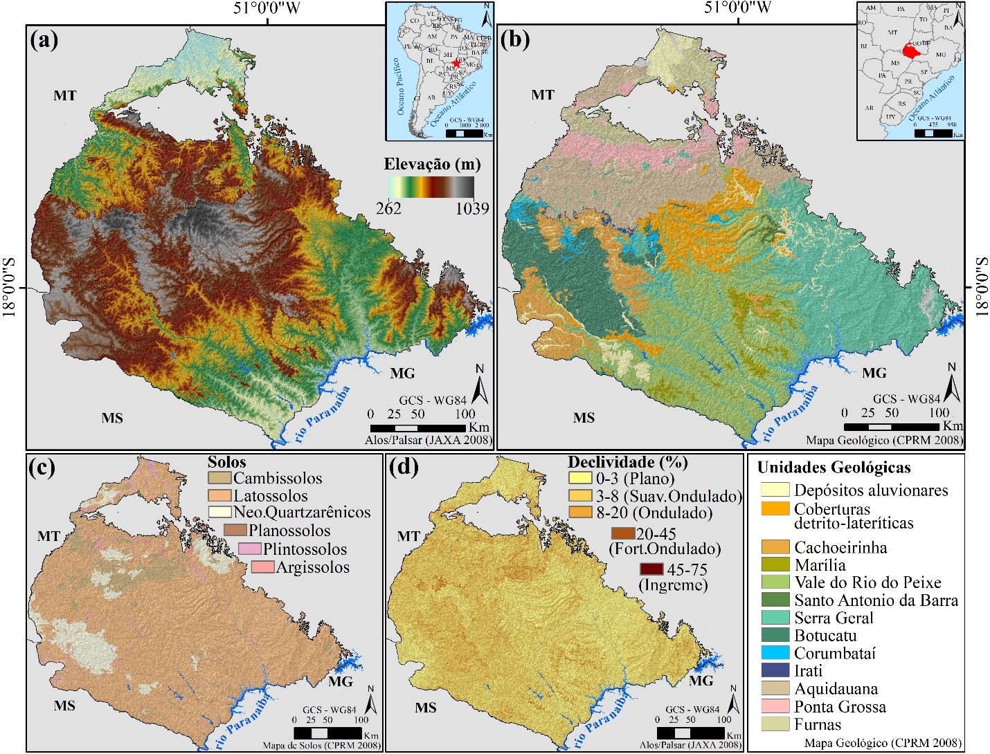
Murundus fields, also known as covoais, are frequent microreliefs in the Cerrado. These are sets of semicircular elevations that protrude from the surface of the land, rounded or oval, with average dimensions of 70 cm in height and 6 m in diameter. They are associated with wetlands and have been impacted by agricultural expansion. The determinants of its regional spatial distribution are still poorly known. This study aimed to identify the natural determinants of its spatial distribution in the Southwest of Goiás, in the Sedimentary Basin of Paraná. All occurrences of murundus fields identified by the project Mapping of Remnant Murundus Fields in the state of Goiás (SEMAD-GO/LAPIG-UFG) were compared with information referring to lithology, geomorphology, NDWI (Normalized Difference Water Index), and SMI (Soil Moisture Index). The indices were obtained from SENTINEL 2-A (MSI) and Landsat 8 (OLI and TIRS) orbital images. It was found that murundus fields preferentially occur in the Alluvial Deposits, Cachoeirinha, Detritic-lateritic Covers, and Serra Geral geological units. Murundus fields predominate under slopes of 0 to 8% (flat to gently undulating relief), and in areas with lower drainage density. The NDWI and the SMI indicated that murundus fields are concentrated on wet surfaces, occurring less frequently in saturated/very wet areas and in moderate humidity, dry, and very dry surfaces.
References
DE ARAUJO NETO, M.; FURLEY, P.; HARIDASAN, M.; JOHNSON, C. The murundus of the cerrado region of Central Brazil. Journal of Tropical Ecology, v. 2, n. 1, p. 17-35, 1986. https://doi.org/10.1017/S0266467400000559
BORGES B.C; BAPTISTA G.M.M. Avaliação da potencialidade do índice de vegetação SFDVI (Spectral Feature Depth Vegetation Index) para a discretização da cobertura do solo em áreas rurais. Anais do XIX Simpósio Brasileiro de Sensoriamento Remoto. Santos, p. 1931-1938, 2019.
CHRISTOFOLETTI, A. Geomorfologia fluvial – São Paulo: Edgard Blucher, 1981, 313 p.
CPRM, Companhia de Pesquisa de Recursos Minerais. (2008). Mapa Geodiversidade do Brasil: Influência da geologia dos grandes geossistemas no uso e ocupação dos terrenos. Brasília: CPRM, p. 68, 2008. Disponível em: http://www.cprm.gov.br/publique/Gestao-Territorial/Gestao-Territorial/Mapas-de-Geodiversidade-Estaduais-1339.html. Acesso em: 10/12/2022.
DARLINGTON, J. P. Lenticular soil mounds in the Kenya highlands. Oecologia. 66:116-21. Berlim, 1985. https://doi.org/10.1007/BF00378562
DE ALBUQUERQUE, E. M. et al. Análise do comportamento do NDVI e NDWI sob diferentes intensidades pluviométricas no Município de Sousa-PB. Revista Estudos Geoambientais, v. 1, n. 1, 2014.
ESRI – Environmental Systems Research Institute Inc. ArcGis versão 10.8. EUA: Environmental Systems Research Institute, 2019.
EMBRAPA - EMPRESA BRASILEIRA DE PESQUISA AGROPECUÁRIA. Sistema brasileiro de classificação de Solos. Brasília. Serviço de produção de informação, 1999. 412p.
FURLEY, P. A. Classification and distribution of murundus in the Cerrado of central Brazil. Journal of Biogeography, v.13, n.3, p. 265-268, 1986. https://doi.org/10.2307/2844925
GAO, H.; LIU, F.; YAN, T.; QIN, L.; LI, Z. Drainage Density and Its Controlling Factors on the Eastern Margin of the Qinghai–Tibet Plateau. Frontiers in Earth Science, v. 9, 2022, p. 1-15. https://doi.org/10.3389/feart.2021.755197
GAOS, B. C. NDWI- A Normalized difference water index for remote sensing of vegetation liquid water from space. Remote Sensing of Environment. v. 58, n. 3, p. 257-266, 1996. https://doi.org/10.1016/S0034-4257(96)00067-3
GOMES FILHO, R.R., SILVA, J.H. da, PAULINO, H.B., CARNEIRO, M.A.C., COSTA, C.A.G. Velocidade de infiltração da água num plintossolo háplico de campo de murundu sob uma cronossequência de interferência antrópica. Revista. Brasielira. Agricultura. Irrigada. 5, 2011, p. 245-253. http://dx.doi.org/10.7127/rbai.v5n300054
HASSAN MK, ABBAS BA, GARAS, SN (2019). Readability, Governance, and performance: a test of the obfuscation hypothesis in Qatari listed firms. Corporate Governance: The International Journal of Business in Society, 19(2), 270-298. https://doi.org/10.1108/CG05-2018-0182
HORTON, R.E. 1945. Erosional development of streams and their drainage basins: hydrophysical approach to quantitative morphology. Geological Society of America Bulletin, v. 56. Boulder. http://dx.doi.org/10.1130/0016-7606(1945)56[275:EDOSAT]2.0.CO;2
Laboratório de Processamento de Imagens e Geoprocessamento - LAPIG. Disponível em: https://www.lapig.iesa.ufg.br/lapig/index.php. Acesso em: 10/12-2022
INPE - INSTITUTO NACIONAL DE PESQUISAS ESPACIAIS. COORDENAÇÃO GERAL DE OBSERVAÇÃO DA TERRA. PRODES – Incremento anual de área desmatada no Cerrado Brasileiro. Disponível em: http://www.obt.inpe.br/cerrado. Acesso em: 25 jul. 2023.
JAXA - Japan Aerospace Exploration Agency. ALOS/PALSAR Level 1.1/1.5 product Format description . NEB-070062A, p.156, 2008.
KER, J. C. Latossolos do Brasil: uma revisão. Geonomos, Belo Horizonte, v. 5, n. 1, p. 17–40, 1997. https://doi.org/10.18285/geonomos.v5i1.187
KÖPPEN W., 1900: Versuch einer Klassifikation der Klimate, vorzugweise nach ihren Beziehungen zur Pflanzenwelt. Geogr. Zeitschrift, 6, 657–679.
LAMBIN, E.F. and EHRLICH, D. (1996) The Surface Temperature-Vegetation Index Space for Land Cover and Land-Cover Change Analysis. International Journal of Remote Sensing, 17, 463-487. https://doi.org/10.1080/01431169608949021.
LIMA, T. P. M. e CORRÊA, R. S. Ocorrência de campos de murundus na paisagem do cerrado do Distrito Federal. Revista Ibero-Americana de Ciências Ambientais, v. 12, n. 9, 2021, p. 536-546.https://doi.org/10.6008/CBPC2179-6858.2021.009.0041
MANTOVANI J. R.; SAKAMOTO A. Y.; GRADELLA F. S.; BRAZ A. M. Análise do comportamento do NDWI sob diferentes intensidades da pluviosidade no Pantanal da Nhecolândia, MS-Brasil. Anais do XVIII Simpósio Brasileiro de Sensoriamento Remoto. Anais eletrônicos. Santos, 2017.
MANTOVANI J. R.; SAKAMOTO. Modelagem Hidrológica na Bacia do Alto Rio Paraguai – BAP. In: A Anais do XIX Simpósio Brasileiro de Sensoriamento Remoto, 2019, Santos. Anais eletrônicos... São José dos Campos, INPE, 2019. Disponível em: https://proceedings.science/sbsr-2019/trabalhos/modelagem-hidrologica-na-bacia-do-alto-rio-paraguai-bap?lang=pt-br. Acesso em: 26 jul., 2023.
MANTOVANI, J. R.; LELIS, L. R. M. Algoritmo para mapeamento dos usos do solo e cobertura vegetal a partir do uso do NDVI: um estudo aplicado no nordeste de Mato Grosso Do Sul. Revista Cerrados, [S. l.], v. 21, n. 02, p. 03–34, 2023. https://doi.org/10.46551/rc24482692202317
MAPBIOMAS – Uso e Ocupação do Solo 2021, Coleção 6. Disponível em: https://mapbiomas.org/. Acesso em: 17 oct., 2022.
MARTINS, F. P.; ROSOLEN, V. S. Caracterização morfológica de uma catena (Latossolo Gleissolo) no campo de murundu do Córrego da Fortaleza, Chapada Uberlândia-Uberaba, Uberlândia-MG. Caminhos de Geografia, v. 15, n. 52, 2014, p. 186-200. https://doi.org/10.14393/RCG155224618
MOREIRA, C. A.; ROSOLEN, V. S.; HANSEN, M. A. F.; MASQUELIN, H.; MOTA, R. Aquifer recharge capacity assessment of an anthropogenically impacted wetland by the DC resistivity geophysical method. Discover Water, 3: 7, 2023, p. 1-14. https://doi.org/10.1007/s43832-023-00031-3
MCFEETERS, S. K. The use of the Normalized Difference Water Index (NDWI) in the delineation of open water features. International Journal of Remote Sensing, v. 17, n. 7, p. 1425-1432. 1996. http://dx.doi.org/10.1080/01431169608948714
NASCIMENTO, M. A. L. Geomorfologia do estado de Goiás. Boletim Goiano de Geografia, Universidade Federal de Goiás. v.12. n.1. p. 7-29. Goiás, 1991. https://doi.org/10.5216/bgg.v12i1.4371
OLIVEIRA-FILHO, A. T. The vegetation of Brazilian ‘murundus’ - the island-effect on the plant community. Journal of Tropical Ecology, v. 8, n. 4, p. 465-486, 1992. https://doi.org/10.1017/S0266467400006817
OLIVEIRA, P.P., FUNCH, R.R. & DOS SANTOS, F. de A.R. First pollen survey of murundus in the Chapada Diamantina region of the state of Bahia, Brazil. Acta Bot. Brasilica v. 28, n. 4, p. 638–640, 2014. https://doi.org/10.1590/0102-33062014abb3562
PARIDA, B. R., OINAM, B., PATEL, N. R., SHARMA, N., KANDWAL, R., HAZARIKA, M. K. Land surface temperature variation in relation to vegetation type using MODIS satellite data in Gujarat state of India. International Journal of Remote Sensing, 29:14, 2008, p. 4219-4235. https://doi.org/10.1080/01431160701871096
PAULINO, H.B.; ASSIS, P.C.R.; VILELA, L.A.F.; CURI, N.; CARNEIRO, M.A.C. Campos de murundus: gênese, paisagem, importância ambiental e impacto da agricultura nos atributos dos solos. Tópicos em Ciência do Solo, v.9, p.75-86, 2015. https://doi.org/10.1590/ S0100-204X2015000400007.
PONCE, V. M.; CUNHA, C. N. Vegetated Earthmounds in Tropical Savannas of Central Brazil: a synthesis - with special reference to the Pantanal do Mato Grosso. Journal of Biogeography, v. 20, n.2, p. 219-225, 1993. https://doi.org/10.2307/2845673
PONZONI, F. J., SHIMABUKURO, Y. E.; KUPLICH, T. M. Sensoriamento remoto aplicado ao estudo da vegetação. 2. ed. São José Dos Campos, Saraiva, 2012.
POTIĆ, I.; BUGARSKI, M.; MATIĆ-VARENICA, J. Soil Moisture Determination Using Remote Sensing Data for The Property Protection and Increase of Agriculture Production, 2017.
REIS, G. S., MIZUSAKI, A. M., ROISENBERG, A., & RUBERT, R. R. Formação Serra Geral (Cretáceo da Bacia do Paraná): um análogo para os reservatórios ígneo-básicos da margem continental brasileira. Pesquisa em Geociências, v. 41, n. 2, p. 155-168, 2014. https://doi.org/10.22456/1807-9806.78093
RESENDE, I. L. M., ARAÚJO G. M., OLIVEIRA, A. P. A., OLIVEIRA, A.P., ÁVILA JÚNIOR, R.S. A comunidade vegetal e as características abióticas de um campo de murundu em Uberlândia, MG. Acta Botânica Brasilica, 18, 2004, p. 9-17. https://doi.org/10.1590/S0102-33062004000100002
ROSOLEN, V.; CAMPOS, A. B.; GOVONE, J. S.; ROCHA, C. Contamination of wetland soils and floodplain sediments from agricultural activities in the Cerrado Biome (State of Minas Gerais, Brazil). Catena, v.128, n.1, p. 203-210, 2015. https://doi.org/10.1016/j.catena.2015.02.007
ROSOLEN V.; BUENO G. T.; MUTEMA M.; MOREIRA C. A.; FARIA I. R.; NOGUEIRA G.; CHAPLOT, V. On the link between soil hydromorphy and geomorphological development in the Cerrado (Brazil) wetlands. Catena, n. 176, pp. 197-208, 2019. https://doi.org/10.1016/j.catena.2019.01.022
SALES J. C.; FERREIRA M. E.; ROSOLEN V.; BUENO G. T. Delimitação de Microrrelevos de Murundus com Veículos Aéreos não Tripulados. Anais do XIX Simpósio Brasileiro de Sensoriamento Remoto. São José dos Campos, 2019.
SALES, J.C.; BUENO, G.T.; ROSOLEN, V.; FERREIRA, M.E.; FURLAN, L.M. The structure of an earth-mound field of the Brazilian Savanna. Geomorphology, 386, 107752, 2021, p. 1-12. https://doi.org/10.1016/j.geomorph.2021.107752
SALES J.C.; LIMA G.S.A.; PASSOS, J.S.; MOREIRA H.G.B.; MACIEL, A.D. Caracterização espectral de um campo de murundus no Planalto dos Guimarães. Anais do XX Simpósio Brasileiro de Sensoriamento Remoto, Florianópolis, p. 2233-2236, 2023.
Secretaria do Meio Ambiente e Desenvolvimento Sustentável- SEMAD. Disponível em: https://www.meioambiente.go.gov.br/noticias/1902-governo-de-goi%C3%A1s-far%C3%A1-mapeamento-in%C3%A9dito-de-campos-de-murundus-no-estado.html. Acesso em: Nov. 07, 2020.
SCHNEIDER, M. O., SILVA, D. B. Estrutura pedológica e dinâmica hídrica do covoal do Córrego da Fortaleza. Sociedade & Natureza, v. 3, n. 5 e 6, p. 75-89, 1991. https://doi.org/10.14393/SN-v3-1991-60692
SHIMABUKURO, Y. E.; IPPOTILI-RAMILO, G. A.; EPIPHANIO, J. C. N.; FORMAGGIO, A. R. Sensoriamento Remoto Orbital como Meio Auxiliar na Previsão de Safras. Agricultura em São Paulo, SP, 46(1), p. 89-101, INPE. São José dos Campos, 1999.
SILVA, E. B.; RIBEIRO, N. B.; FERREIRA, N. C.; BUENO, G.T.; SANTOS, A. C.; CARDOSO, M. R. D.; DISARZ, R. Mapeamento de campos de murundus no Estado de Goiás. Anais do XX Simpósio Brasileiro de Sensoriamento Remoto. Florianópolis, 2023, p. 1140-1142.
SILVA, G.A.; BORGES, M. S.; RODRIGUES, S. C. Avaliação geomorfométrica de campo de murundus no Chapadão do Diamante, Serra da Canastra, Minas Gerais, Brasil. Caderno de Geografia, v. 30, p. 36-51, 2020. https://doi.org/10.5752/P.2318-2962.2020v30nesp1p36-51
SILVA, T. L., MARQUES, E. L., GUILHERME, E. Avifauna em quatro fitofisionomias do complexo vegetacional sobre areia branca do sudoeste amazônico. In: BRITO, T. F., SILVA, R. C., OLIVEIRA S. A. V., SILVEIRA, M. Complexo vegetacional sobre areia branca: campinaranas do sudoeste da Amazônia. Universidade Federal do Acre, Rio Branco, 2017, p 39-48.
SILVA, F. A. M. da; ASSAD, E. D.; EVANGELISTA, B. A. Caracterização climática do bioma Cerrado. In: SANO, S. M. (ed.); ALMEIDA, S. P. de. (ed.); RIBEIRO, J. F. (ed.). Cerrado: ecologia e flora. Brasília: Embrapa Informação Tecnológica, 2008. p. 69-88. https://doi.org/10.1590/2236-8906-43/2014
UNITED STATES GEOLOGICAL SURVEY – USGS. Provisional Landsat 8 Surface Reflectance Code (LaSRC) Product. Versão 3.3. Disponível em from: Acesso em: Oct. 2016.
USGS. Landsat 8 (L8) Data Users Handbook. Version 1.0. Department of the Interior, U.S. Geological Survey, 2015.
ZANTER, K. Landsat 8 Surface Reflectance Code (LASRC) Product Guide. USGS: Sioux Falls, SD, USA, p. 39, 2019.
ZEDLER, J.B.; KERCHER, S. Wetland Resources: Status, Trends, Ecosystem Services, and Restorability. Annual Review of Environment and Resources, 15 (30), 2005, p. 39-74. https://doi.org/10.1146/annurev.energy.30.050504.144248
ZENG, Y. FENG, Z. XIANGA, N. (2004). Assessment of soil moisture using Landsat ETM+ temperature/vegetation index in semiarid environment. IEEE Transactions on Geosciences and Remote Sensing, v. 6, p. 4036-4039, 2004. https://doi.org/10.1109/IGARSS.2004.1370089
ZHAN, Z.; QIN, Q.; WANG, X. The application of LST/NDVI index for monitoring land surface moisture in semiarid area. IEEE Transactions on geosciences and Remote Sensing, v. 3, p. 1551-1554, 2004. https://doi.org/10.1109/IGARSS.2004.1370609

This work is licensed under a Creative Commons Attribution 4.0 International License.
Copyright (c) 2023 Amanda Morais Malheiro , Veronica Natalia Boeira, Guilherme Taitson Bueno, José Roberto Mantovani